
MyTopo
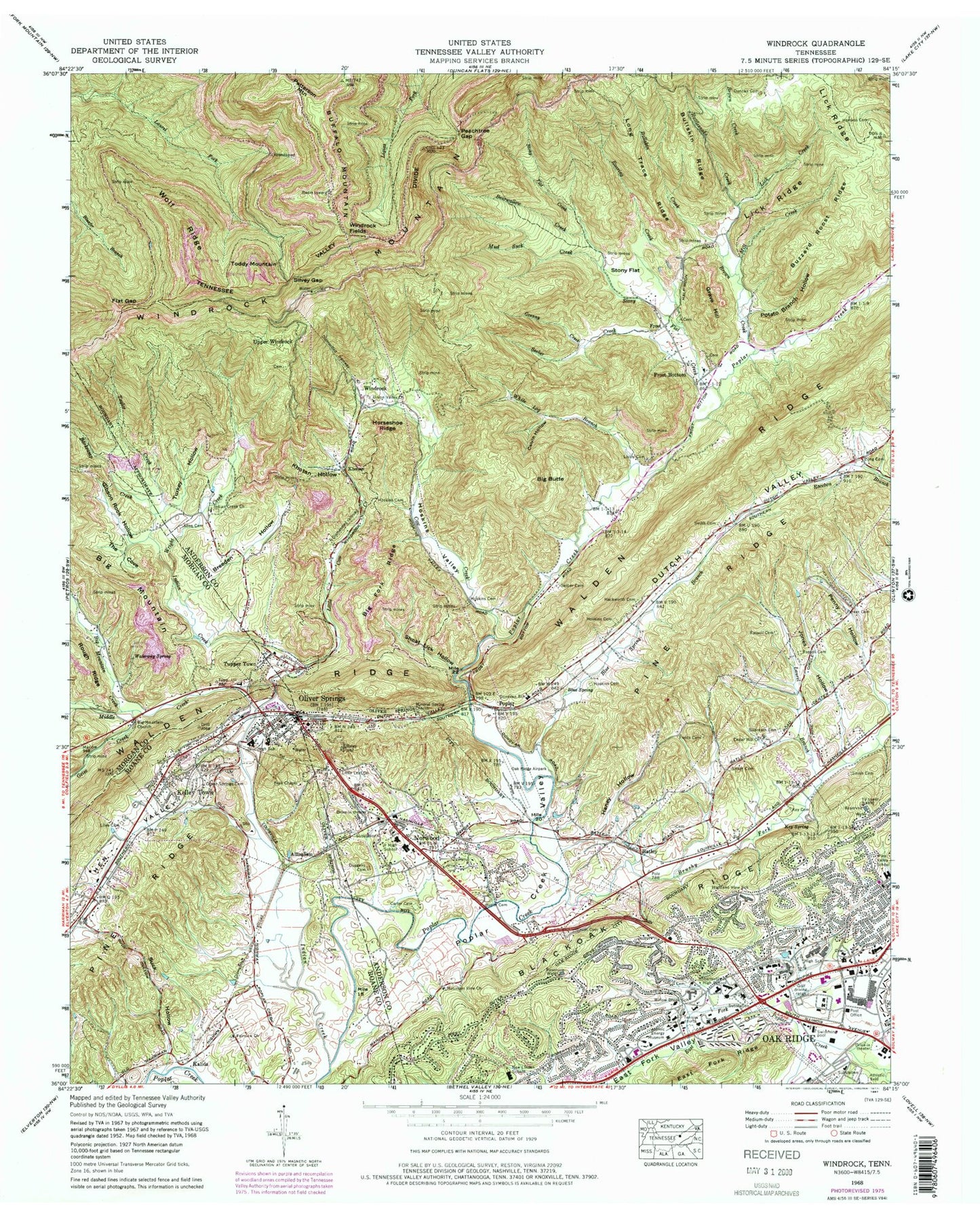
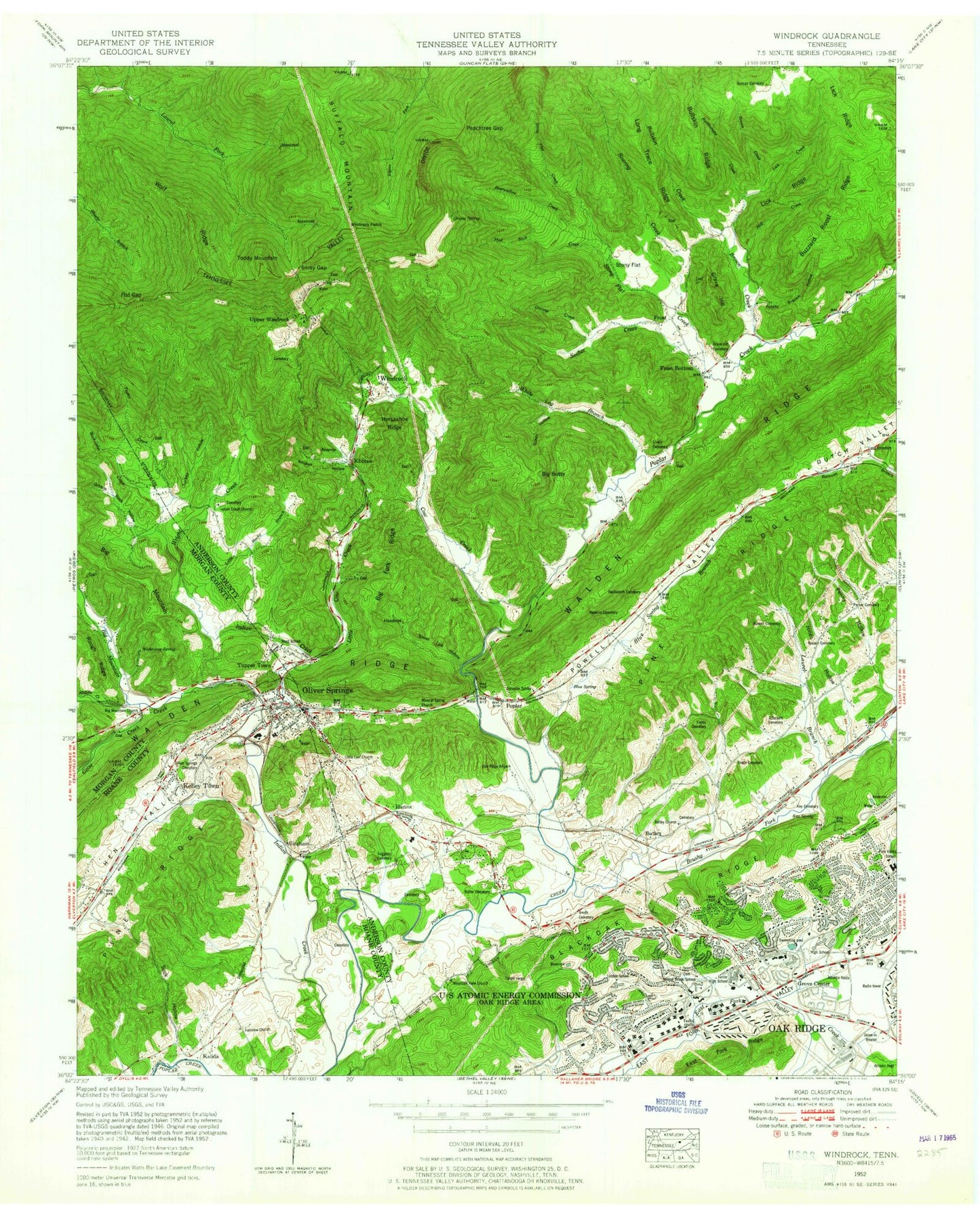
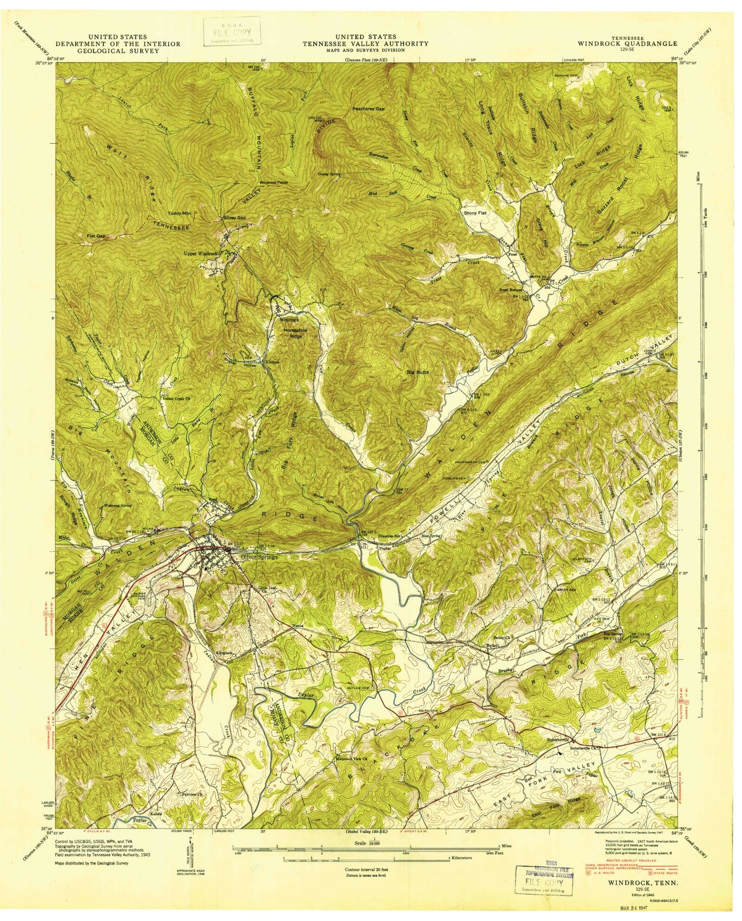
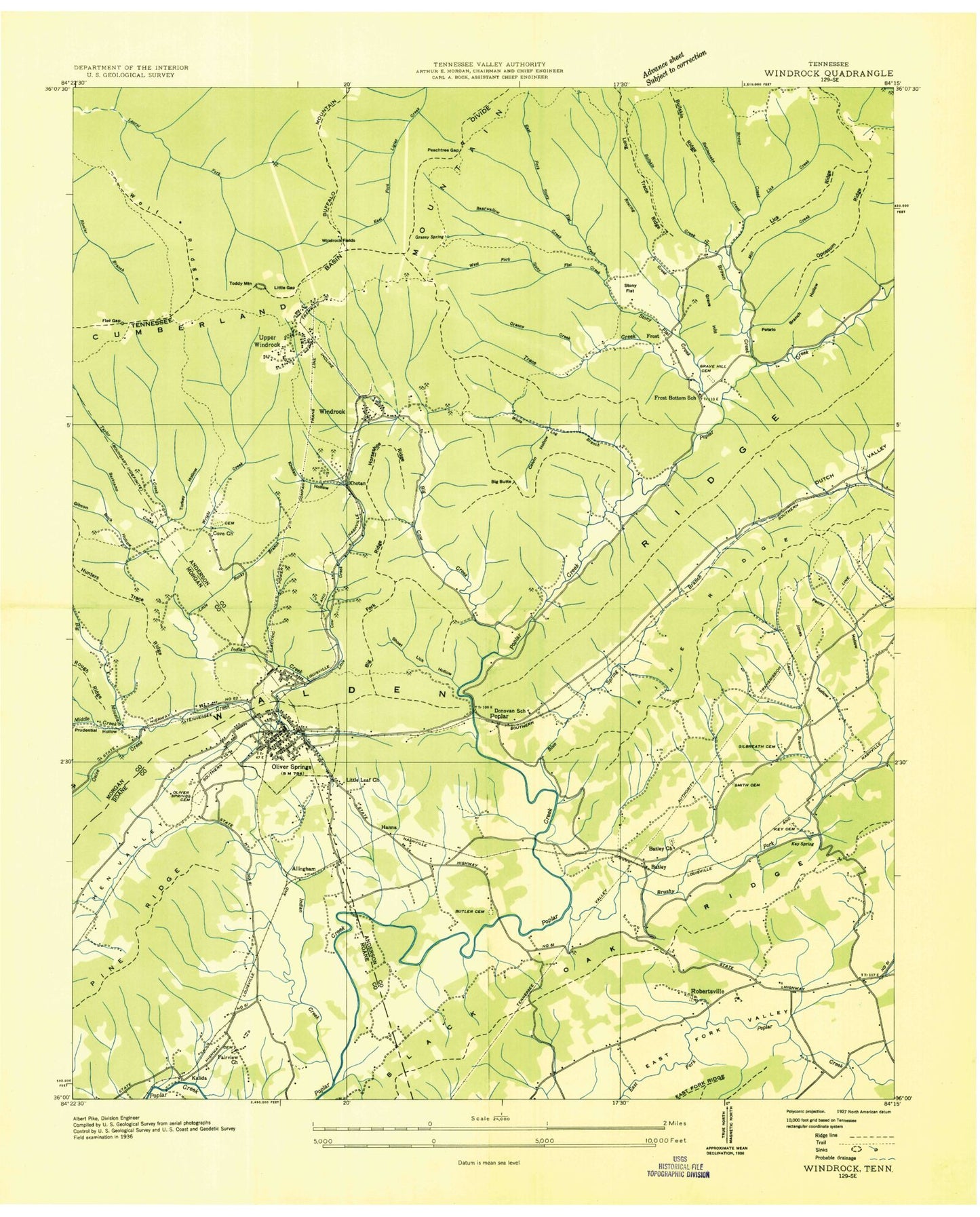
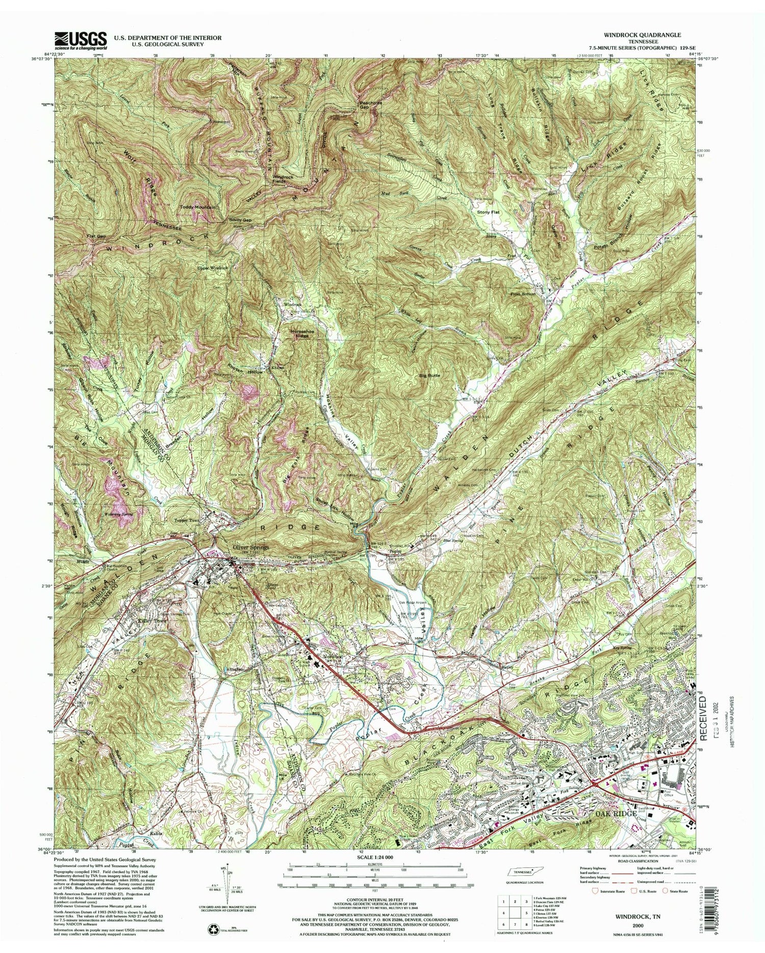
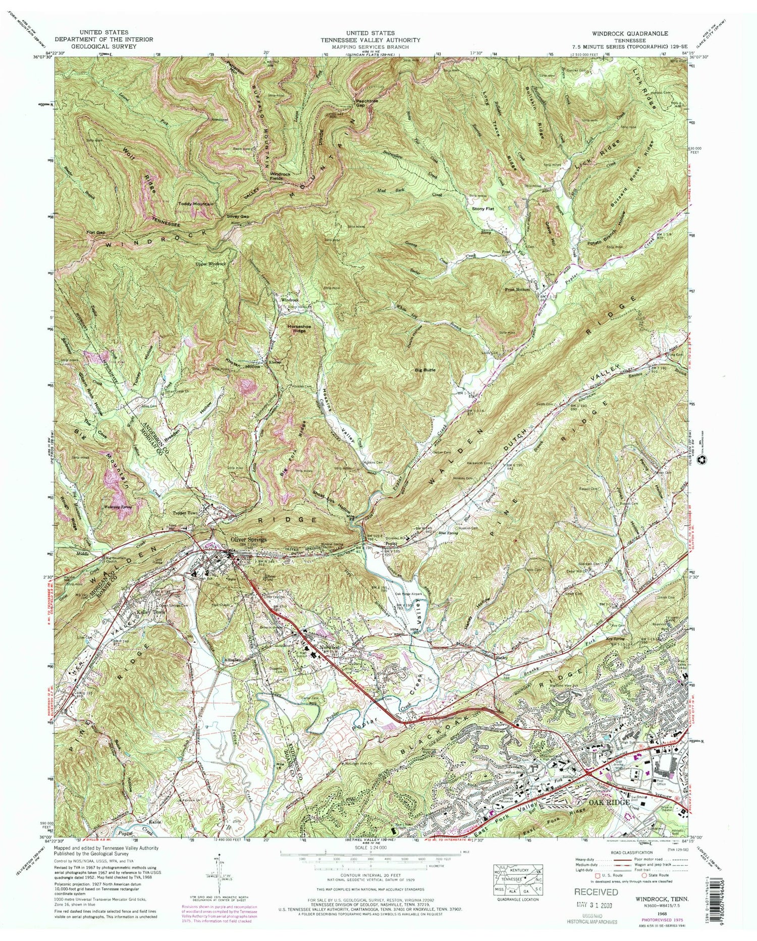
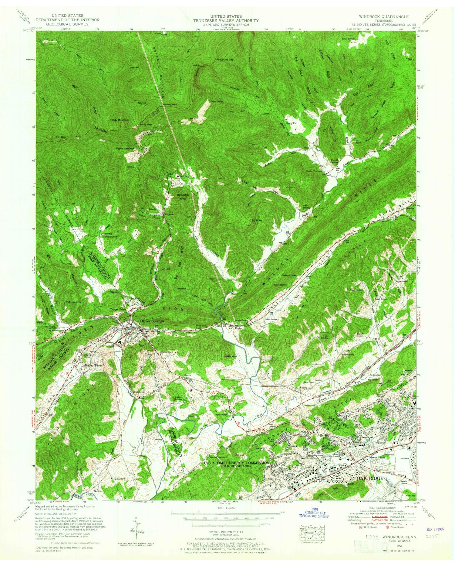
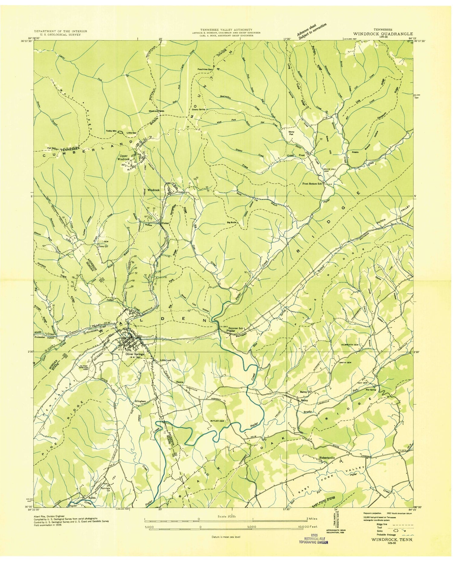
Classic USGS Windrock Tennessee 7.5'x7.5' Topo Map
Couldn't load pickup availability
Historical USGS topographic quad map of Windrock in the state of Tennessee. Typical map scale is 1:24,000, but may vary for certain years, if available. Print size: 24" x 27"
This quadrangle is in the following counties: Anderson, Morgan, Roane.
The map contains contour lines, roads, rivers, towns, and lakes. Printed on high-quality waterproof paper with UV fade-resistant inks, and shipped rolled.
Contains the following named places: Blackoak Ridge, Shoat Lick Hollow, Smith Cemetery, Smith Cemetery, Smith Cemetery, Smith Cemetery, Stony Flat, Suck Hollow, Sweet Cemetery, Taylor Creek, The Cove, Toddy Mountain, Turkey Hollow, Waterway Spring, Windrock Fields, Windrock Mountain, Wolf Ridge, Wright Creek, Allen Cemetery, Barkcamp Creek, Bearwallow Creek, Big Butte, Big Fork Ridge, Big Mountain Church, Blue Spring, Breeden Hollow, Brown Creek, Bullskin Creek, Bullskin Ridge, Butler Cemetery, Calvin Hollow, Carter Cemetery, Cedar Hill Church, Donovan School, Duggans Cemetery, Duncan Cemetery, Dutch Valley, Fairview Church, Fields Cemetery, Flat Gap, Frost Bottom, Geise Creek, Gibson Rock Hollow, Galbreath Cemetery, Granny Creek, Grave Hill, Hackworth Cemetery, Haney Hollow, Harness Cemetery, Highland View School, Horseshoe Ridge, Hoskins Cemetery, Hoskins Cemetery, Hoskins Cemetery, Hoskins Cemetery, Hoskins Valley, Indian Creek, Jones Hollow, Kelley Town, Key Cemetery, Key Spring, Khotan Hollow, Laurel Branch, Lick Creek, Lick Ridge, Liles Cemetery, Little Cow Creek, Little Leaf Baptist Church, Lively Cemetery, Long Cemetery, Long Trace Ridge, Mill Creek, New Mountain View Baptist Church, Mud Suck Creek, Linden Elementary School, Norwood, Oak Ridge, Oliver Springs, Oliver Springs Cemetery, Parker Cemetery, Peachtree Gap, Peak Chapel, Penny Hollow, Potato Branch Hollow, Prudential Hollow, Rattlesnake Creek, Roaring Creek, Robertsville Middle School, Russell Cemetery, Russell Cemetery, Seeber Creek, Seiber Cemetery, Oliver Springs Inc Airport, Middle Creek, Pine Ridge, Silvey Gap, Stony Flat Creek, Tupper Town, Union Valley Baptist Church, White Log Branch, Willow Brook Elementary School, Atomic Energy Museum, Big Mountain Creek, Blue Spring Branch, Brushy Fork, Buzzard Roost Ridge, Cow Creek, Indian Creek Primitive Baptist Church, Mineral Spring Baptist Church, A K Bissell Park, Asbery Mine, Batley Baptist Church, Downtown Shopping Cneter, East Fork Stony Flat Creek, Fairview (historical), Four Oaks Shopping Center, Frost Bottom School (historical), Grassy Spring, Grave Hill Cemetery, Grove Center, Grove Shopping Center, Hecks Shopping Center, Jefferson Shopping Center, Lasalle Park, Linden School (historical), Norwood Elementary School, Norwood Junior High School, Oak Ridge Civic Center, Oak Ridge High School, Oak Ridge Shopping Center, Pine Valley Shopping Center, Reed School (historical), Robertsville, South Hills Golf Club, Winters Gap, Little Rocky Branch, Church of God, District 7 (historical), Faith Lutheran Church, First Assembly of God Church, First United Methodist Church, First Wesleyan Church, Hilltop Shopping Center, New York Avenue Church of Christ, Oak Ridge Unitarian Church, Robertsville Baptist Church, Royce Baptist Church, Saint Stephens Episcopal Church, Trinity United Methodist Church, West Village Christian Church, Upper Windrock, Windrock, Allingham, Batley, Frost, Kalida, Khotan, Poplar, Oliver Springs Elementary School, Oliver Springs High School, Frost Bottom Baptist Church, Lower Windrock School (historical), Saint Marys School, Tuppertown Baptist Church, Upper Windrock School (historical), Frost Cemetery, Indian Creek Cemetery, Mineral Spring Cemetery, Batley Cemetery, WORI-AM (Oak Ridge), WBTZ-AM (Oliver Springs), WCPT-TV (Crossville), Beech Park Baptist Church, Hunter Spring, Kellytown Baptist Church, Oliver Springs First Baptist Church, Big Mountain Hollow, Oak Ridge Division (historical), Walden Ridge Division (historical), Jackson Brothers Mine, Oak Ridge Post Office, Oliver Springs Post Office, Calvary Baptist Church, Central Baptist Church, First Church of the Nazarene, First Freewill Baptist Church, Highland View Church of Christ, Saint Marys Catholic Church, Town of Oliver Springs, Commissioner District 5, Oliver Springs Fire Department, Oak Ridge Fire Department Headquarters, Marlow Volunteer Fire Department Donovan Station, Oliver Springs Fire Department Station 2, Oak Ridge Fire Department Station 3, Oak Ridge Police Department, Oliver Springs Police Department, Blackoak Ridge, Shoat Lick Hollow, Smith Cemetery, Smith Cemetery, Smith Cemetery, Smith Cemetery, Stony Flat, Suck Hollow, Sweet Cemetery, Taylor Creek, The Cove, Toddy Mountain, Turkey Hollow, Waterway Spring, Windrock Fields, Windrock Mountain, Wolf Ridge, Wright Creek, Allen Cemetery, Barkcamp Creek, Bearwallow Creek, Big Butte, Big Fork Ridge, Big Mountain Church, Blue Spring, Breeden Hollow, Brown Creek, Bullskin Creek, Bullskin Ridge, Butler Cemetery, Calvin Hollow, Carter Cemetery, Cedar Hill Church, Donovan School, Duggans Cemetery, Duncan Cemetery, Dutch Valley, Fairview Church, Fields Cemetery