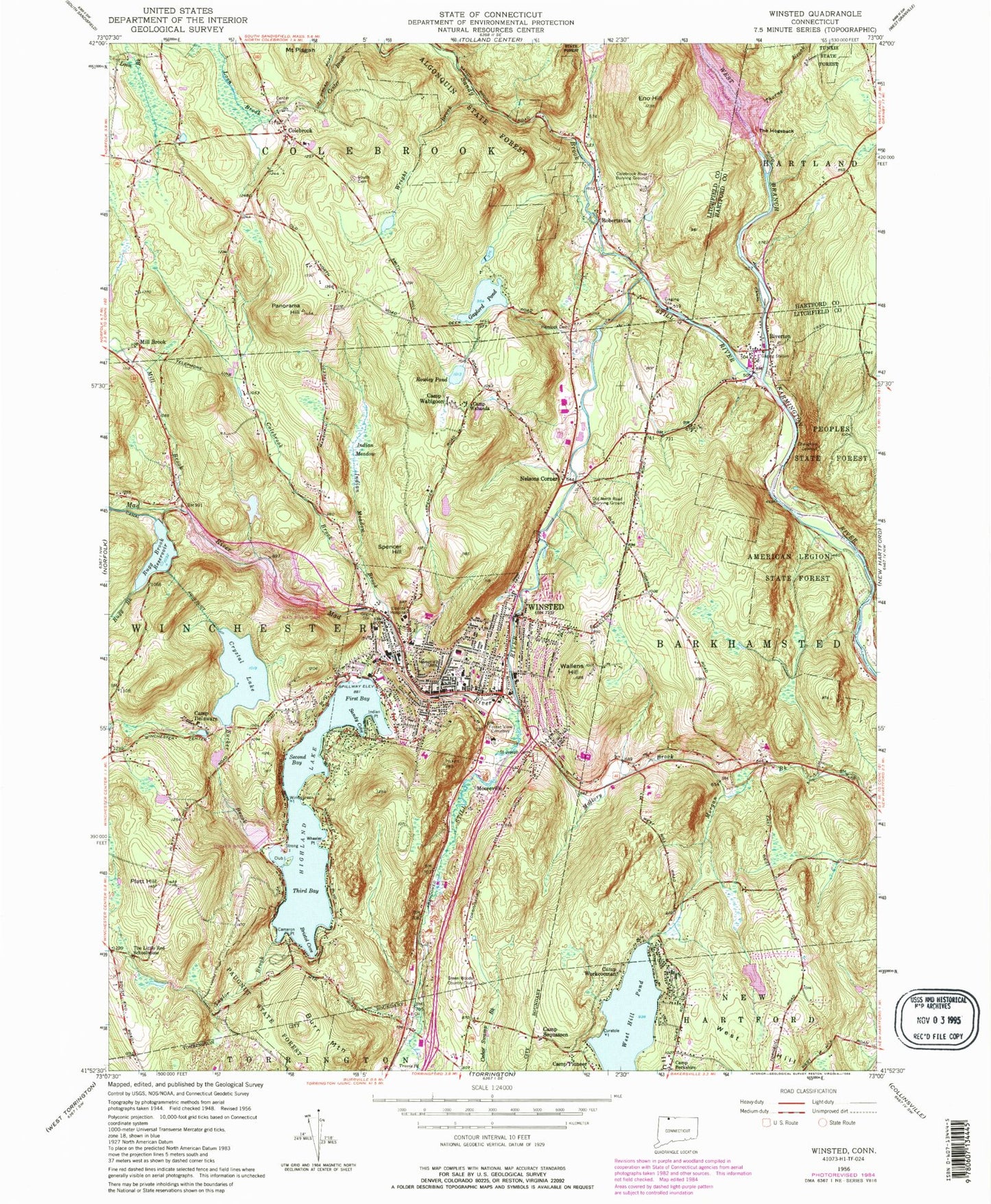
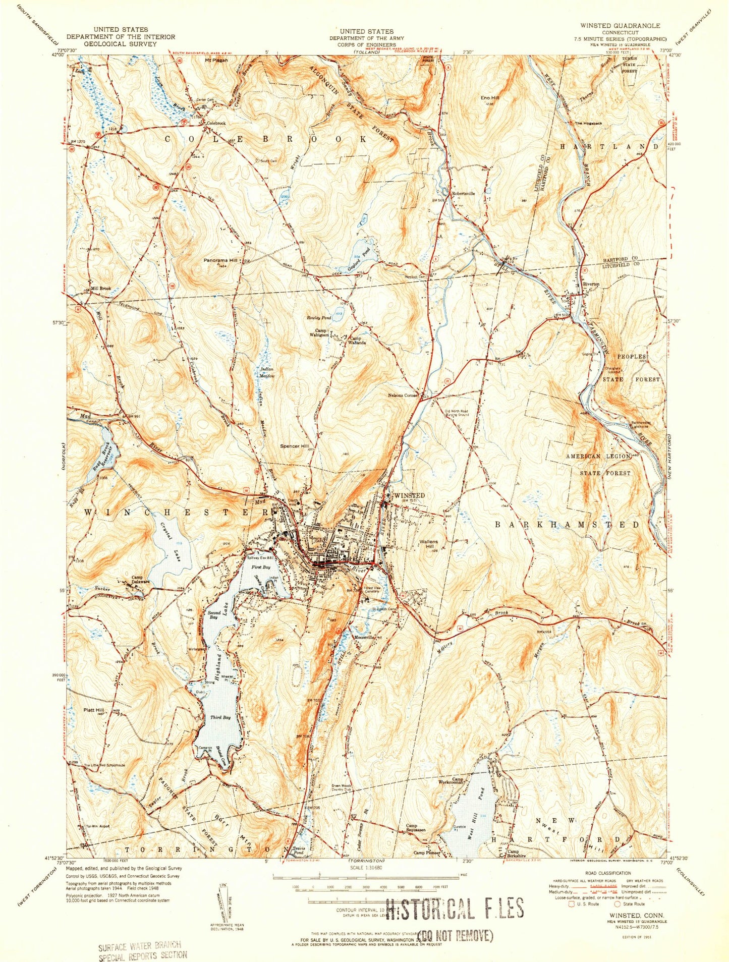
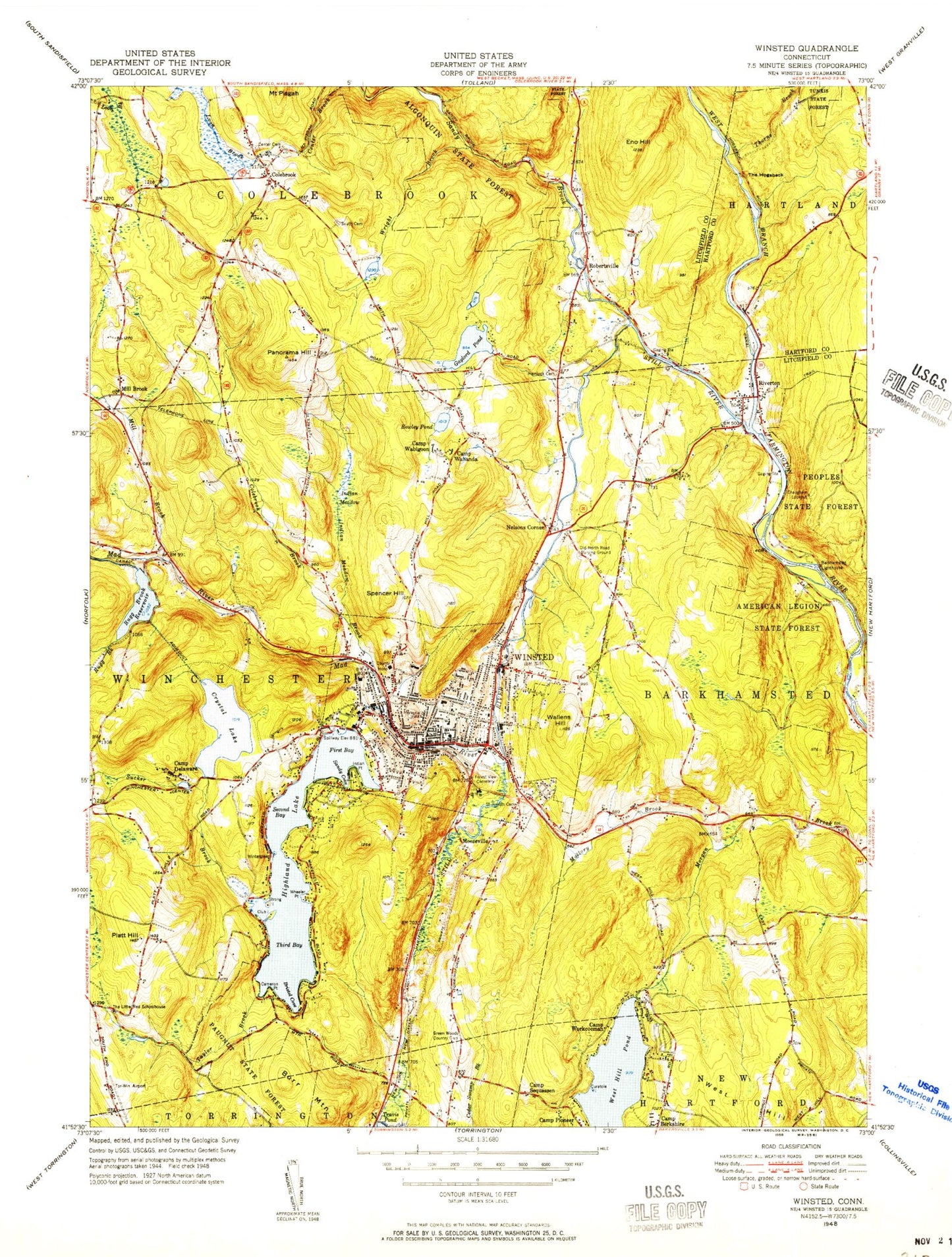
MyTopo
Classic USGS Winsted Connecticut 7.5'x7.5' Topo Map
Couldn't load pickup availability
Historical USGS topographic quad map of Winsted in the state of Connecticut. Typical map scale is 1:24,000, but may vary for certain years, if available. Print size: 24" x 27"
This quadrangle is in the following counties: Hartford, Litchfield.
The map contains contour lines, roads, rivers, towns, and lakes. Printed on high-quality waterproof paper with UV fade-resistant inks, and shipped rolled.
Contains the following named places: West Branch Reservoir, Algonquin State Forest, American Legion State Forest, Bristol Cove, Burr Mountain, Cameron Point, Camp Delaware, Camp Pioneer, Camp Sequassen, Camp Wabigoon, Camp Wahanda, Camp Workcoeman, Center Cemetery, Chaugham Lookout, Club Island, Colebrook, Colebrook Brook, Colebrook River Burial Ground, Crystal Lake, Curatole Island, Eno Hill, First Bay, Forest View Cemetery, Gaylord Pond, Hemlock Cemetery, Highland Lake, Indian Meadow, Indian Meadow Brook, Indian Point, Loon Brook, Mad River, Mad River Dam, Mallory Brook, Mill Brook, Old North Road Burial Ground, Panorama Hill, Platt Hill, Riverton, Rowley Pond, Rugg Brook, Rugg Brook Reservoir, Saint Joseph Cemetery, Sandy Brook, Sandy Cove, Second Bay, South Cemetery, Spencer Hill, Still River, Strong Island, Sucker Brook, Sucker Brook Dam, Taylor Brook, The Little Red Schoolhouse, Third Bay, Thorne Brook, Wallens Hill, West Hill Pond, Wheeler Point, Winsted, Wintergreen Island, Wright Brook, Mill Brook, Mooreville, Nelsons Corner, Robertsville, Green Woods Country Club, Town of Winchester, Rugg Brook Reservoir Dam, Crystal Lake Dam, Highland Lake Dam, Laurel Lake Dam, West Hill Pond Dam, Robertsville Dam, Gaylord Pond Dam, Sucker Brook Reservoir, Mad River Reservoir, Goodwin Dam, Schwartz Pond Dam, Schwartz Pond, Ames Plaza Shopping Center, Austin Hawes Campground, Babb Hill, Batcheller Primary School, Beardsley Memorial Library, Brodie Park, Camp Delaware Pond, Colebrook Center Fire Department, Charles Arnold Recreation Area, Church of Christ Baptist Church, Club Island Park, Colebrook Congregational Church, Colebrook Consolidated School, Colebrook Historical Society Building, Colebrook Post Office, Colebrook Town Hall, Faith Bible Church, First Church of Winsted, First Narrows, Colebrook Forge Fire Department, Gilbert High School, Gothic Union Episcopal Church, Greenwoods Industrial Park, Hatch Landing (historical), Highland Lake Club, Hinsdale Elementary School, Hurtbut Cove, John T Kenney Hitchcock Museum, Kings Plaza Shopping Center, Laurel Crest Campground, Laurel Lake, Laurel Park, Moore Bridge, Northwestern Connecticut Community College Library, Northwestern Connecticut Community College, Northwester Regional High School, Pearson Middle School, Platt Hill State Park, Riverton Cemetery, Riverton Congregational Church, Rogers Corners (historical), Rowley Park Plaza Shopping Center, Riverton Post Office, Winsted Census Designated Place, Winsted Fire Marshal's Office, Winsted Fire Department Headquarters, Colebrook Fire Department, Riverton Volunteer Fire Company, Winsted Fire Department Union Engine Company 1, Winsted Fire Department Cascade Engine Company 3 and 4, Winsted Area Ambulance Association, Winchester Police Department, Riverton Census Designated Place, West Branch Reservoir, Algonquin State Forest, American Legion State Forest, Bristol Cove, Burr Mountain, Cameron Point, Camp Delaware, Camp Pioneer, Camp Sequassen, Camp Wabigoon, Camp Wahanda, Camp Workcoeman, Center Cemetery, Chaugham Lookout, Club Island, Colebrook, Colebrook Brook, Colebrook River Burial Ground, Crystal Lake, Curatole Island, Eno Hill, First Bay, Forest View Cemetery, Gaylord Pond, Hemlock Cemetery, Highland Lake, Indian Meadow, Indian Meadow Brook, Indian Point, Loon Brook, Mad River, Mad River Dam, Mallory Brook, Mill Brook, Old North Road Burial Ground, Panorama Hill, Platt Hill, Riverton, Rowley Pond, Rugg Brook, Rugg Brook Reservoir, Saint Joseph Cemetery, Sandy Brook, Sandy Cove, Second Bay, South Cemetery, Spencer Hill, Still River, Strong Island, Sucker Brook, Sucker Brook Dam, Taylor Brook, The Little Red Schoolhouse, Third Bay, Thorne Brook, Wallens Hill, West Hill Pond, Wheeler Point, Winsted, Wintergreen Island, Wright Brook, Mill Brook, Mooreville, Nelsons Corner, Robertsville, Green Woods Country Club, Town of Winchester, Rugg Brook Reservoir Dam, Crystal Lake Dam, Highland Lake Dam, Laurel Lake Dam, West Hill Pond Dam, Robertsville Dam, Gaylord Pond Dam, Sucker Brook Reservoir, Mad River Reservoir, Goodwin Dam, Schwartz Pond Dam, Schwartz Pond, Ames Plaza Shopping Center, Austin Hawes Campground, Babb Hill, Batcheller Primary School, Beardsley Memorial Library, Brodie Park, Camp Delaware Pond, Colebrook Center Fire Department, Charles Arnold Recreation Area, Church of Christ Baptist Church, Club Island Park, Colebrook Congregational Church, Colebrook Consolidated School, Colebrook Historical Society Building, Colebrook Post Office, Colebrook Town Hall, Faith Bible Church, First Church of Winsted, First Narrows, Colebrook Forge Fire Department, Gilbert High School, Gothic Union Episcopal Church, Greenwoods Industrial Park, Hatch Landing (historical), Highland Lake Club