MyTopo
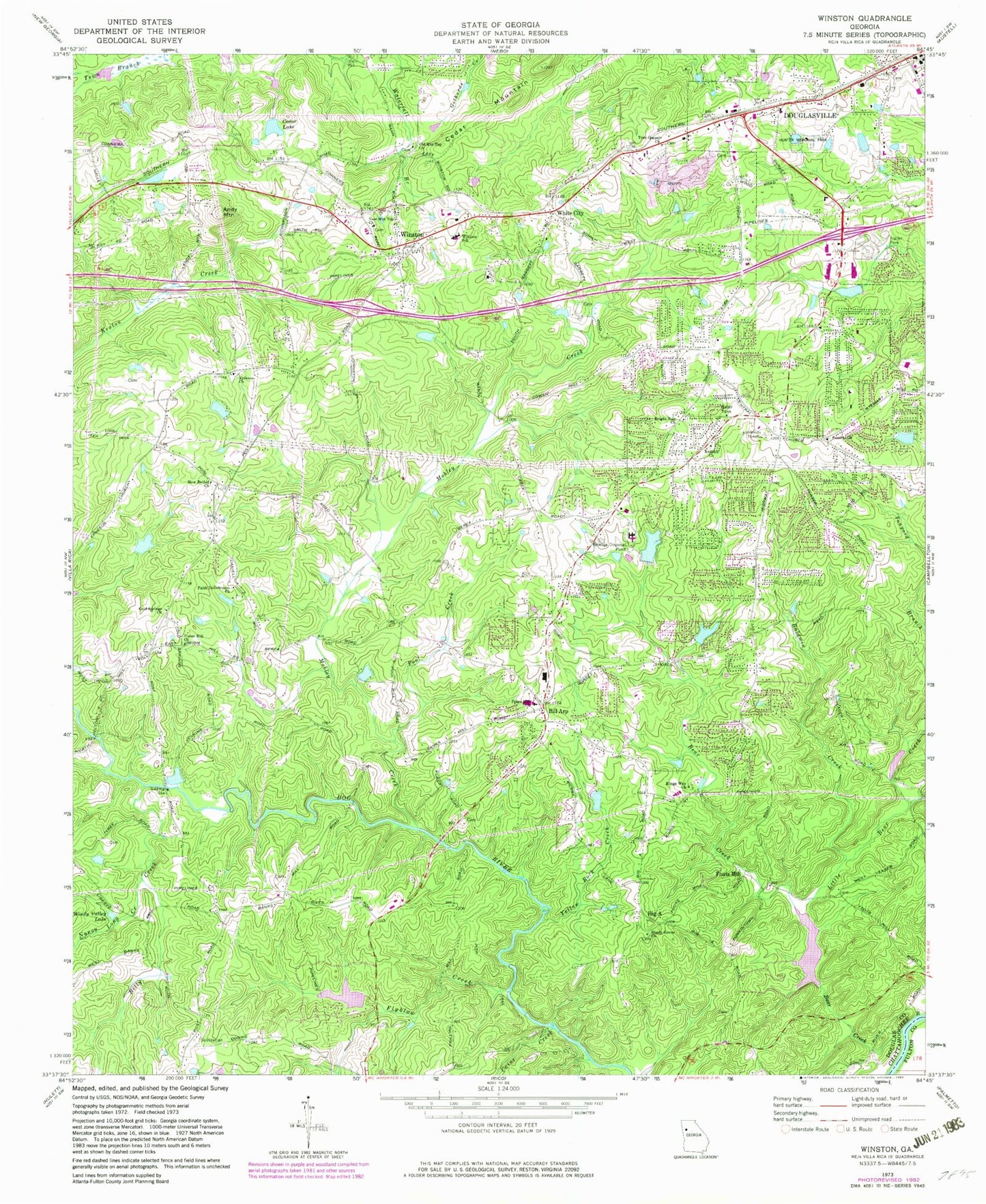
Classic USGS Winston Georgia 7.5'x7.5' Topo Map
Couldn't load pickup availability
Historical USGS topographic quad map of Winston in the state of Georgia. Typical map scale is 1:24,000, but may vary for certain years, if available. Print size: 24" x 27"
This quadrangle is in the following counties: Douglas, Fulton.
The map contains contour lines, roads, rivers, towns, and lakes. Printed on high-quality waterproof paper with UV fade-resistant inks, and shipped rolled.
Contains the following named places: Baldwin Creek, Bear Creek, Big A, Billy Creek, Bright Star Church, Caine Creek, Cedar Lake, Cedar Mountain, Central Church, Ephesus Church, Faith Deliverance Church, Flyblow Creek, Hunter Memorial Park, Kings Way Church, Little Bear Creek, Mobley Creek, Nancy Long Creek, New Bethel Church, New Mountain Top Church, Old Mountain Top Church, Pool Creek, Prays Mill Church, Shady Grove Church, True Gospel Church, Union Hall Church, Windy Valley Lake, Winston Elementary School, Yellow Rock Creek, White City, Andy Mountain, Fouts Mill, Winston, Lake Sarah Glenn Dam, Lake Sarah Glenn, Thurmon Lake Dam, Thurmon Lake, Cedar Lake Dam, Mill Glenn Lake Dam, Mill Glenn Lake, Hay North Lake Dam, Hay North Lake, Barnett Lake Dam, Barnett Lake, Noland Lake Dam, Noland Lake, Talerico Lake Dam, Talerico Lake, Spring Hill Lake Dam, Spring Hill Lake, Johnson Lake Dam, Johnson Lake, Flyblow Creek Dam, Lake Sweetwater, Bill Arp, Cold Springs Church, Aberdeen Estates, Alexander High School, Aline Estates, Arbor Square Shopping Center, Arbor Station Elementary School, Audubon Forest, Bear Creek Estates, Bent Pine, Bill Arp Elementary School, Blain Woods, Boulevard Center Shopping Center, Bright Star, Camp Inageh, Canaan Camp, Coronado Forest, Cowan Mill Estates, Daniell Mill Estates, Dorsett Shoals Elementary School, Douglas Corner Shopping Center, Douglas County, Douglas County Public Library, Douglas Ridge, Douglasville School (historical), Easons Lake, Ephesus Heights, Executive Heights, F M Boatwright Memorial Park, Glen Ridge, Goodwindy Estates, Gregory Heights, Imperial Estates, Johnson Land, Kingdom Missionary Church, Kings Point, Kings West, Laurel Heights, Market Square Shopping Center, Mill Glen, Montage Manor, Oakdale Estates, Orchard Park, Park Place Shopping Center, Phillips Mill, Seminole Valley, Shallowford Heights, Sherrian Estates, Stewart Mill Acres, Sugar Creek, Sweetwater Bluff, Kings Way Christian School, The Noles Estates, The Oaks, Twin Pine Estates, West Lake, Western Pines Country Club, White Oak Estates, Winston Church, Woods Valley, Worthington Estates, Douglas County Courthouse, Daniells Mill (historical), Pumpkintown Ferry (historical), Bill Arp Division, Fairplay Division, Winston Division, Cedar Mountain Village Shopping Center, Cosby Station Shopping Center, Douglas County Fire Department Station 10, Douglas County Fire EMS Department Station 2, Douglas County Fire Department Station 3, Douglas Crossing Shopping Center, Douglasville City Hall, Douglasville Crossroads Shopping Center, Douglasville Marketplace Shopping Center, Douglas County Sheriff's Office, Bright Star Elementary School, Douglasville Adventist School, Douglas County College and Career Institute, Mason Creek Elementary School, Mason Creek Middle School, Yeager Middle School, Heirway Christian Academy, Douglas County Jail, Douglasville Post Office, Winston Post Office