MyTopo
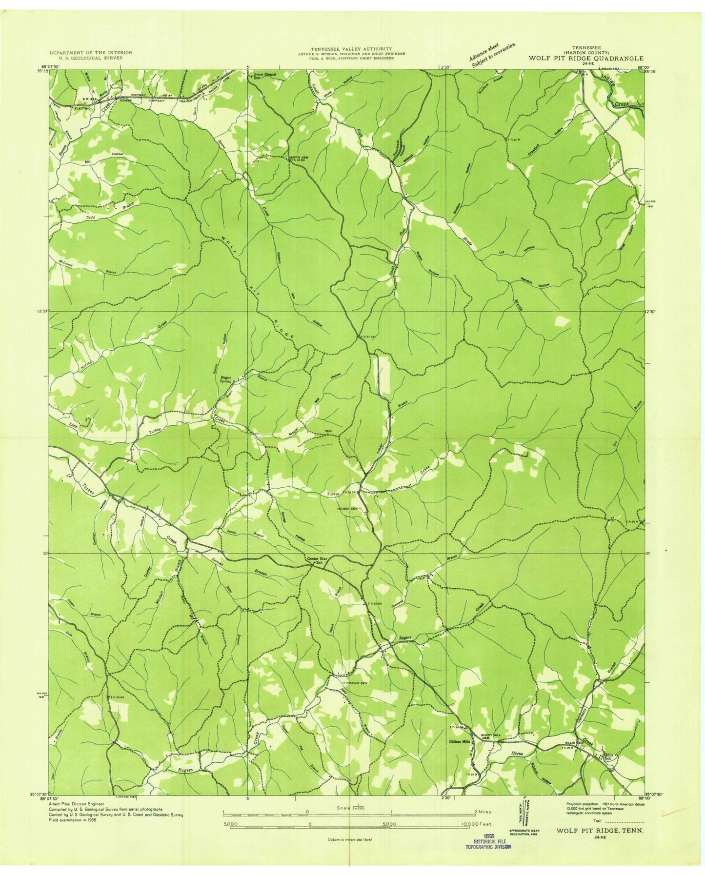
Classic USGS Wolf Pit Ridge Tennessee 7.5'x7.5' Topo Map
Couldn't load pickup availability
Historical USGS topographic quad map of Wolf Pit Ridge in the state of Tennessee. Typical map scale is 1:24,000, but may vary for certain years, if available. Print size: 24" x 27"
This quadrangle is in the following counties: Hardin.
The map contains contour lines, roads, rivers, towns, and lakes. Printed on high-quality waterproof paper with UV fade-resistant inks, and shipped rolled.
Contains the following named places: Jerrolds Branch, Mozier Mill Hollow, Smith Cemetery, Smith Hollow, Sunny Hill Cemetery, Sutton Hollow, Vanbibber Hollow, White Hollow, Wildcat Hollow, Wilson Branch, Wolf Pit Ridge, Baugus Branch, Baugus Hollow, Boon Cemetery, Brady Branch, Bratton Cemetery, Cashion Hollow, Cook Hollow, Copeland Branch, Crawford Hollow, Davis Branch, Davis Hollow, Dudley Hollow, Duncan Hollow, Franks Cemetery, George Hollow, Germany Branch, Gillis Cemetery, Gillis School, Gobbler Branch, Godwin Branch, Godwin Mill Hollow, Harbert Hills Academy, Hendrix Hollow, Jack Hollow, Lacefield Cemetery, Martin Hollow, McClarin Hollow, Mitchell Branch, Nichols Branch, Petty Branch, Pickens Cemetery, Poplar Flat Branch, Porter Mill Branch, Puncheon Hollow, Rainey Hollow, Rocky Branch, Sambo Branch, Baugus Spring, Wilkerson Cemetery, Abrams Chapel, Bratton Hollow, District 5 (historical), Smith Branch, Wildcat Hollow, Center Star, Gillises Mills, Alder Grove School (historical), Brooks Cemetery, Center Star School (historical), Dickson Cemetery, Franks Cemetery, Hames Cemetery, Harbour Cemetery, Jerrold Cemetery, King Cemetery, Lacefield Cemetery, McLaren Cemetery, Smith Cemetery, Smith-Rose Cemetery, Stricklin Cemetery, Tilley Cemetery, Union Chapel School (historical), Vanbidder Cemetery, Welch Cemetery, Wilkerson Cemetery, Wilkerson Cemetery, WDNX-FM (Olive Hill), Hardin County Fire Department / Emergency Management District 10, Jerrolds Branch, Mozier Mill Hollow, Smith Cemetery, Smith Hollow, Sunny Hill Cemetery, Sutton Hollow, Vanbibber Hollow, White Hollow, Wildcat Hollow, Wilson Branch, Wolf Pit Ridge, Baugus Branch, Baugus Hollow, Boon Cemetery, Brady Branch, Bratton Cemetery, Cashion Hollow, Cook Hollow, Copeland Branch, Crawford Hollow, Davis Branch, Davis Hollow, Dudley Hollow, Duncan Hollow, Franks Cemetery, George Hollow, Germany Branch, Gillis Cemetery, Gillis School, Gobbler Branch, Godwin Branch, Godwin Mill Hollow, Harbert Hills Academy, Hendrix Hollow, Jack Hollow, Lacefield Cemetery, Martin Hollow, McClarin Hollow, Mitchell Branch, Nichols Branch, Petty Branch, Pickens Cemetery, Poplar Flat Branch, Porter Mill Branch, Puncheon Hollow, Rainey Hollow, Rocky Branch, Sambo Branch, Baugus Spring, Wilkerson Cemetery, Abrams Chapel, Bratton Hollow, District 5 (historical), Smith Branch, Wildcat Hollow, Center Star, Gillises Mills, Alder Grove School (historical), Brooks Cemetery, Center Star School (historical), Dickson Cemetery, Franks Cemetery, Hames Cemetery, Harbour Cemetery, Jerrold Cemetery, King Cemetery, Lacefield Cemetery, McLaren Cemetery, Smith Cemetery, Smith-Rose Cemetery, Stricklin Cemetery, Tilley Cemetery, Union Chapel School (historical), Vanbidder Cemetery, Welch Cemetery, Wilkerson Cemetery, Wilkerson Cemetery, WDNX-FM (Olive Hill), Hardin County Fire Department / Emergency Management District 10