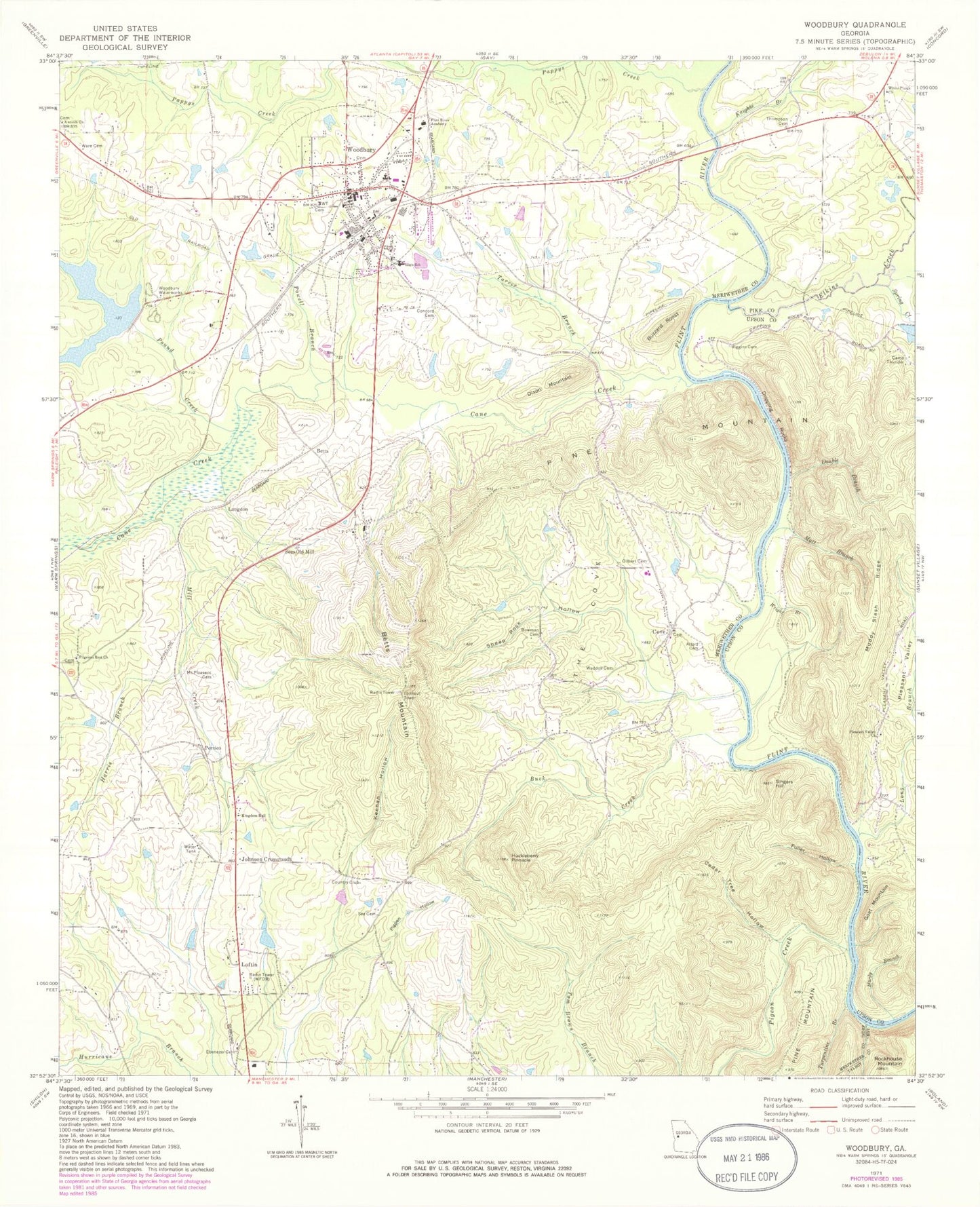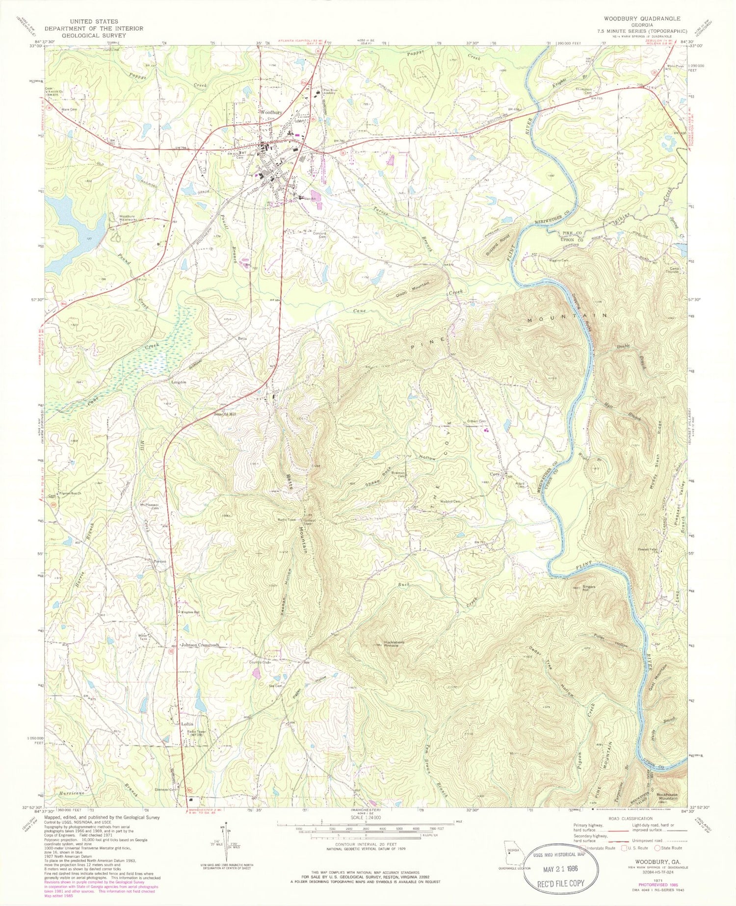
MyTopo
Classic USGS Woodbury Georgia 7.5'x7.5' Topo Map
Couldn't load pickup availability
Historical USGS topographic quad map of Woodbury in the state of Georgia. Typical map scale is 1:24,000, but may vary for certain years, if available. Print size: 24" x 27"
This quadrangle is in the following counties: Meriwether, Pike, Talbot, Upson.
The map contains contour lines, roads, rivers, towns, and lakes. Printed on high-quality waterproof paper with UV fade-resistant inks, and shipped rolled.
Contains the following named places: Alford Cemetery, Bowman Cemetery, Buck Creek, Cane Creek, Cedar Tree Hollow, Concord Cemetery, Double Branch, Dripping Rocks, Ebenezer Cemetery, Flint River Academy, Fuller Hollow, Gilbert Cemetery, Hardy Branch, Harris Branch, Keenan Hollow, Kingdom Hall, Knights Branch, Long Branch, Matt Branch, Mill Creek, Mount Pleasant Cemetery, Muddy Slash Ridge, Pappys Creek, Pigeon Creek, Pigpen Hollow, Pilgrims Rest Church, Pleasant Valley, Pleasant Valley Church, Pound Creek, Powell Branch, Riggins Cemetery, Rockhouse Mountain, See Cemetery, Sees Old Mill, Sheep Rock Hollow, Spring Creek, Tarver Branch, The Cove, Thompson Cemetery, Turpentine Branch, Waddell Cemetery, Ware Cemetery, White Plains Church, Wright Branch, Johnson Crossroads, Betts, Betts Mountain, Buzzard Roost, Dixon Mountain, Goat Mountain, Huckleberry Pinnacle, Langdon, Loftin, Persico, Singers Hill, Woodbury, Cane Creek Structure Number Two Dam, Cane Creek Structure Number Two Lake, Carroll Dam, Carroll Lake, Woodbury Waterworks, White Plains Cemetery, White Plains School (historical), Holy Hill Church, Pleasant Valley School (historical), Alford School (historical), Bethesda Church Cemetery, Bethesda School (historical), Bethesda United Methodist Church, Campbell School (historical), Cove Church, Eberneza Primitive Baptist Church (historical), Eberneza School (historical), Girard Ford, Halls Bridge (historical), Iron Bridge, Melton Ford, Mount Pleasant Congregational Church (historical), Riggins Bridge (historical), West Brown Cemetery, George E Washington Elementary School, Woodbury High School, WFDR-AM (Manchester), Antioch Baptist Church, Cove, Elkins Creek, Manchester Division, Woodbury Division, City of Woodbury, Woodbury Volunteer Fire Department Station 13, Meriwether County Volunteer Fire Department Station 9, Woodbury Police Department, Woodbury Post Office, Cove Church Cemetery, Woodbury Cemetery, Pilgrim Rest Baptist Church Cemetery