MyTopo
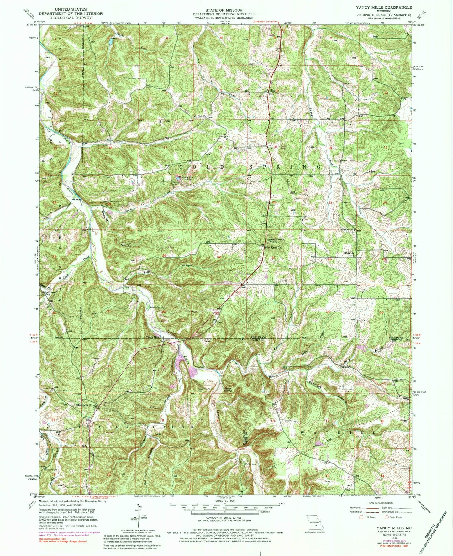
Classic USGS Yancy Mills Missouri 7.5'x7.5' Topo Map
Couldn't load pickup availability
Historical USGS topographic quad map of Yancy Mills in the state of Missouri. Typical map scale is 1:24,000, but may vary for certain years, if available. Print size: 24" x 27"
This quadrangle is in the following counties: Dent, Phelps.
The map contains contour lines, roads, rivers, towns, and lakes. Printed on high-quality waterproof paper with UV fade-resistant inks, and shipped rolled.
Contains the following named places: Yancy School (historical), Green Bush School (historical), Grayson School, Ben Fore School, Brookshire Cemetery, Carmack Hollow, Church of God, Coalpit Hollow, Corn Creek, Corn Creek Cemetery, Finn Branch, Gourd Creek, Hines Branch, Huskey Cemetery, Jackson Cemetery, Kitchens Branch, Lane Spring, Miller Cemetery, Moselle Mine, Mount Zion Baptist Church, Paddy Branch, Perry Branch, Peter Branch, Philadelphia Church, Pilot Knob, Pilot Knob Church, Piney Spring, Rhea Church, Riley Branch, Solomon Hollow, Vida, Williams Creek, Yancy Mills, Rhea School, Cross School (historical), Silver Fox Farm (historical), Yancy Spring, Blossom Rock Trail, Pilot Knob Lookout Tower, Cedar Bluff Trail, Lane Spring Campground, Yancy Mills Post Office, Yancy Mills Post Office (historical), Teeters Lake Dam, Allison and Haas Lake Dam, Allen Cemetery, Rolla Rural Fire Protection Association South, King Cemetery, Mount Zion Cemetery, Old Philadelphia Baptist Church / Fore Cemetery, Peck Cemetery, Pilot Knob Cemetery, Rhea Cemetery, Wright Slave Cemetery, George Lane Cemetery, Yancy School (historical), Green Bush School (historical), Grayson School, Ben Fore School, Brookshire Cemetery, Carmack Hollow, Church of God, Coalpit Hollow, Corn Creek, Corn Creek Cemetery, Finn Branch, Gourd Creek, Hines Branch, Huskey Cemetery, Jackson Cemetery, Kitchens Branch, Lane Spring, Miller Cemetery, Moselle Mine, Mount Zion Baptist Church, Paddy Branch, Perry Branch, Peter Branch, Philadelphia Church, Pilot Knob, Pilot Knob Church, Piney Spring, Rhea Church, Riley Branch, Solomon Hollow, Vida, Williams Creek, Yancy Mills, Rhea School, Cross School (historical), Silver Fox Farm (historical), Yancy Spring, Blossom Rock Trail, Pilot Knob Lookout Tower, Cedar Bluff Trail, Lane Spring Campground, Yancy Mills Post Office, Yancy Mills Post Office (historical), Teeters Lake Dam, Allison and Haas Lake Dam, Allen Cemetery, Rolla Rural Fire Protection Association South, King Cemetery, Mount Zion Cemetery, Old Philadelphia Baptist Church / Fore Cemetery, Peck Cemetery, Pilot Knob Cemetery, Rhea Cemetery, Wright Slave Cemetery, George Lane Cemetery