MyTopo
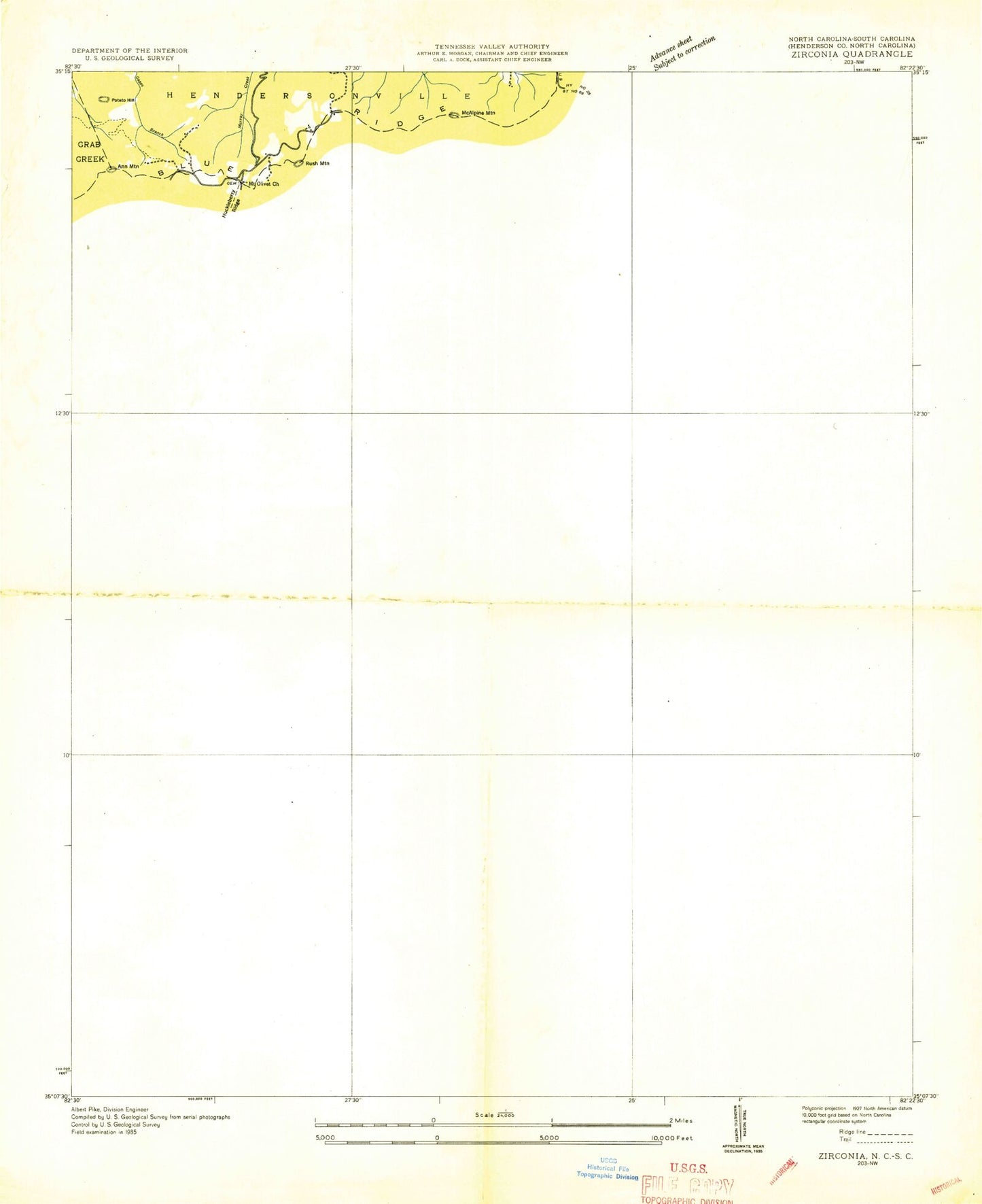
Classic USGS Zirconia North Carolina 7.5'x7.5' Topo Map
Couldn't load pickup availability
Historical USGS topographic quad map of Zirconia in the states of North Carolina, South Carolina. Typical map scale is 1:24,000, but may vary for certain years, if available. Print size: 24" x 27"
This quadrangle is in the following counties: Greenville, Henderson.
The map contains contour lines, roads, rivers, towns, and lakes. Printed on high-quality waterproof paper with UV fade-resistant inks, and shipped rolled.
Contains the following named places: Andrews Cemetery, Bayne Bane Capps Cemetery, Bell Creek, Bobs Creek, Bobs Creek Church, Cabin Creek, Camp Arrowhead, Camp Green Cove, Camp Windy Wood, Cold Branch, Crossroads Church, Davis Creek, Double Springs Cemetery, Double Springs Church, Elks Club Camp, Evans Mountain, Falling Creek, Freeman Creek, Green River Church, Green River Church, Lake Hosea, Huckleberry Ridge, Joe Creek, Jones Creek, Kings Mountain Camp, Mountain Valley Baptist Church Cemetery, Mountain Valley Church, Mountain View Church, Pace Cemetery, Panther Gap, Rock Creek, Smoky Mountain, Lake Summit, Terry Creek, Tuxedo, Vernon Creek, Ward Mountain, Zion Hill Church, Zirconia Church, Lake Shelia, Lake Hosea Dam, Lake Summit Dam, Ann Mountain, Butler Mountain, Hammond Mountain, Hetherly Height, Long Mountain, Mackerel Mountain, McAlpine Mountain, Mount Olive, Mountain Valley, Potato Hill, Rice Knob, Rush Mountain, Vance Mountain, Zirconia, Township of Green River, Green River Volunteer Fire and Rescue Department, Bell Mountain Airport, Zirconia Post Office, Ward Family Cemetery, Mountain View Baptist Church Cemetery, Mount Olivet Baptist Church Cemetery, Zirconia Missionary Baptist Church Cemetery, Crossroads Baptist Church Cemetery, Big Top, Corbin Mountain, Frank Mountain, McCarrol Mountain, Panther Mountain, Awanita Lake, Beaverdam Creek, Big Falls, Calahan Branch, Camp Old Indian, Camp White Pine, Guest Creek, Little Falls Creek, Little Piney Mountain, Mullinax Cemetery, North Saluda Reservoir, Posey Creek, Posey Mountain, Pruett Mountain, Walnut Mountain, Calahan Mountain, Cedar Mountain, Chestnut Springs, High Spur Knob, Hyde Mountain, Mill Knob, Old Indian Mountain, Phillips Mountain, Pine Mountain, Plumley Mountain, Rocky Mountain, Stanton Mountain, Terry Creek, South Carolina Noname 23003 Dam, Lake Caldwell Dam D-3297, Lake Caldwell, Casteel Pond Number One Dam D-2835, Casteel Pond Number Three Dam D-2836, Bradburn Pond Dam D-1171, Camp Chawa (historical), Merrittsville (historical), Mertville School (historical), North Fork School (historical), Terry Creek Pentecostal Holiness Church Graveyard, Wildwood Park (historical), Big Falls Creek, Fall Creek, Gap Creek, North Fork Church, Saluda Mountains, Terry Creek Church, North Fork Baptist Church Graveyard, Hagood - Hightower Family Cemetery, Glassy Mountain Fire Department Station 38, The Cliffs Valley Census Designated Place, Andrews Cemetery, Bayne Bane Capps Cemetery, Bell Creek, Bobs Creek, Bobs Creek Church, Cabin Creek, Camp Arrowhead, Camp Green Cove, Camp Windy Wood, Cold Branch, Crossroads Church, Davis Creek, Double Springs Cemetery, Double Springs Church, Elks Club Camp, Evans Mountain, Falling Creek, Freeman Creek, Green River Church, Green River Church, Lake Hosea, Huckleberry Ridge, Joe Creek, Jones Creek, Kings Mountain Camp, Mountain Valley Baptist Church Cemetery, Mountain Valley Church, Mountain View Church, Pace Cemetery, Panther Gap, Rock Creek, Smoky Mountain, Lake Summit, Terry Creek, Tuxedo, Vernon Creek, Ward Mountain, Zion Hill Church, Zirconia Church, Lake Shelia, Lake Hosea Dam, Lake Summit Dam, Ann Mountain, Butler Mountain, Hammond Mountain, Hetherly Height, Long Mountain, Mackerel Mountain, McAlpine Mountain, Mount Olive, Mountain Valley, Potato Hill, Rice Knob, Rush Mountain, Vance Mountain, Zirconia, Township of Green River, Green River Volunteer Fire and Rescue Department, Bell Mountain Airport, Zirconia Post Office, Ward Family Cemetery, Mountain View Baptist Church Cemetery, Mount Olivet Baptist Church Cemetery, Zirconia Missionary Baptist Church Cemetery, Crossroads Baptist Church Cemetery, Big Top, Corbin Mountain, Frank Mountain, McCarrol Mountain, Panther Mountain, Awanita Lake, Beaverdam Creek, Big Falls, Calahan Branch, Camp Old Indian, Camp White Pine, Guest Creek, Little Falls Creek, Little Piney Mountain, Mullinax Cemetery, North Saluda Reservoir, Posey Creek, Posey Mountain, Pruett Mountain, Walnut Mountain, Calahan Mountain, Cedar Mountain, Chestnut Springs, High Spur Knob, Hyde Mountain, Mill Knob, Old Indian Mountain, Phillips Mountain, Pine Mountain, Plumley Mountain, Rocky Mountain, Stanton Mountain, Terry Creek, South Carolina Noname 23003 Dam, Lake Caldwell Dam D-3297, Lake Caldwell, Casteel Pond Number One Dam D-2835, Casteel Pond Number Three Dam D-2836, Bradburn Pond Dam D-1171, Camp Chawa (historical), Merrittsville (historical), Mertville School (historical), North Fork School (historical), Terry Creek Pentecostal Holiness Church Graveyard, Wildwood Park (historical), Big Falls Creek, Fall Creek, Gap Creek, North Fork Church, Saluda Mountains, Terry Creek Church