MyTopo
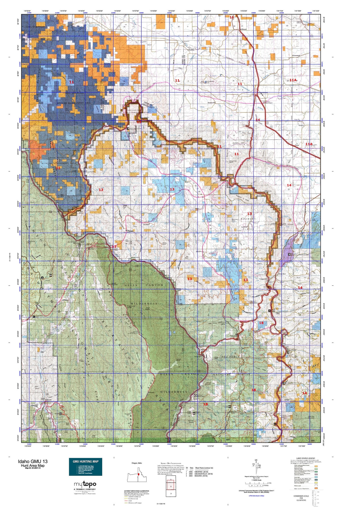
Idaho GMU 13 Map
Couldn't load pickup availability
Hunting unit map of Idaho Game Management Unit 13 with topographic lines and unit boundaries. This topo map features UTM / MGRS and Latitude/Longitude grids, plus public land ownership. It comes folded on waterproof paper. Be fully prepared for your hunt with a MyTopo GMU map!.
This map contains the following named places: Banks Creek,Bar Creek,Basin Creek,Battle Ground,Bean Creek,Berland Ranch,Big Canyon Creek,Big Foot Island,Big Hammer Creek,Big Sulphur Creek,Billy Creek,Birch Creek,Bob Creek,Boles,Brown,Brust Creek,Burnt Creek,Butcherknife Creek,Cactus Mountain,Camp Creek,Camp Howard Cow Camp,Camp Thomas,Canfield,Cat Creek,Cat Creek Ranch,Center Creek,Chalk Creek,Chief Joseph War Historical Marker,China Creek,Chinese Massacre Cove,Christie Creek,Christie Creek Forest Service Station,Christmas Creek,Christmas Creek Camp,Circle C Ranch,City of Cottonwood,City of Ferdinand,City of White Bird,Cook,Copper,Copper Creek,Copper Creek Lodge,Copperville,Corral Creek,Corral Creek Ranch,Cottonwood,Cottonwood Butte,Cottonwood Creek,Cottonwood Division,Cottonwood Job Corps Center,Cougar Creek,Cow Creek,Crooks Corral,Davidson,Davis Ranch,Deep Creek,Deer Creek,Dellas Peak,Devils Garden,Divide Creek,Dixon Corrals,Dixon Cow Camp,Dobbin Cabin,Dog Creek,Dorrance Cow Camp,Dorrance Ranch,Doug Creek,Dry Creek,Dry Creek Island,Dry Point,Dug Bar Boat Ramp,Dug Bar Recreation Site,Eagle Creek,East Fork Deer Creek,Englishman Hill,Eureka Creek Cabin,Fall Creek,Fall Point,Ferdinand,Fick Point,Fir Creek,First Creek,Flynn Creek,Flynn Creek Ranch,Forest,Fourmile Creek,Fourth Creek,Getta Creek,Giants Nose,Grave Creek,Grave Point,Gregory Creek,Guthery Creek,Haas Horse Troughs,Hammer Creek,Hammer Creek Recreation Site,Harlin Mill,Hayes,Haystack Mountain,Hells Gate Creek,Herb Brown,High Breaks Creek,Highrange Creek,Hiltsley Creek,Home Sweet Home Creek,Howard Creek,Indian Creek,Joe Creek,Joe Point,John Day Creek,Johnson Creek,Jones Creek,Joseph,Kernan Point,Keuterville,Kilgore Orchard,Kirby Creek,Kirkwood Creek,Klopton Creek,Kneeland Place,Kurry Creek,Kylie Creek,Lawyer Creek,Lee Creek,Left Fork Divide Creek,Left Fork Dry Creek,Left Fork Wolf Creek,Lightning Creek,Litch Ranch,Little Fir Creek,Little Hammer Creek,Little Sulphur Creek,Lower Pittsburg Landing,Lyon Creek,Lyons Mining Camp,Mahoney Creek,Maloney Creek,McCulley Creek,McKinzie Creek,Mexican Place,Miller Creek,Mockmer Butte,Mollie Point,Morrow,North Fork Christie Creek,North Fork Joe Creek,North Fork Klopton Creek,North Fork Willow Creek,Otto Creek,Packers Creek,Parliament,Pittsburgh Landing,Pleasant Valley Island,Poe Creek,Poodle Creek,Pool Knob,Pot Creek,Price Creek,Quinn Creek,Rail Creek,Rattlesnake Creek,Rhett Creek,Rhodes Creek Ranch,Rice Creek,Rickman Creek,Riddle Lodge,Right Fork Rock Creek,Robertson Ridge,Robinson,Rock Creek,Rose Lewis Point,Round Spring Creek,Rusell,Salmon River,Scully Creek,Second Creek,Sharkey Creek,Sheep Creek,Shuck Creek,Skeleton Creek,Skookumchuck Campground,Skookumchuck Creek,Slate Creek,Slate Creek District Ranger Station,Slick Ear Creek,Slippy Creek,Soldiers Home Creek,Somers Point,Somers Ranch,Sotin Creek,South Fork Birch Creek,South Fork Christie Creek,South Fork Joe Creek,South Lewis Division,Spencer Ranch,Spring Camp Ranch,Square Mountain,Sugarloaf Butte,Sugarloaf Knob,Swamp Creek,Taylor,Telcher Creek,The Knob,Third Creek,Thompson Place,Thorn Creek,Thorn Creek Guard Station,Trail Creek,Triangle Mountain,Tryon Creek Ranch,Tulley Creek Ranch,Twin Bridges Access Area,Upper Pittsburg Landing,Upper Pittsburgh Landing,Walters Ranch,Wapshilla Creek,West Creek,West Fork Deer Creek,West Fork Maloney Creek,West Fork West Creek,Westlake,White Bird,White Bird Creek,Wickiup Creek,Wild Cow Creek,Wild Horse Butte,Wildcat Creek,Willow Creek,Wilson,Wilson Ranch,Windy Point,Wolf Creek,Wyley Creek,Zigzag Creek,Zumwalt