MyTopo
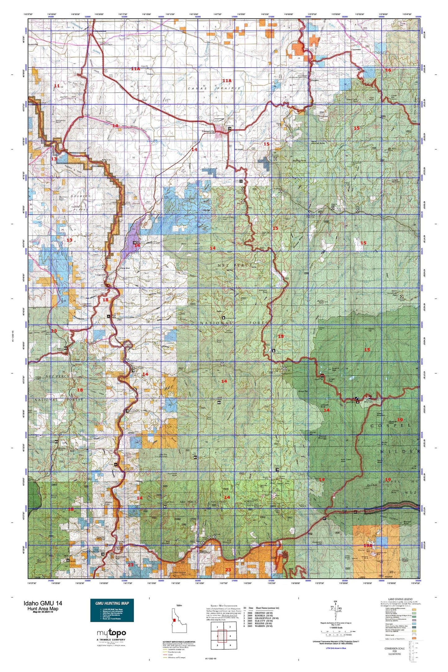
Idaho GMU 14 Map
Couldn't load pickup availability
Hunting unit map of Idaho Game Management Unit 14 with topographic lines and unit boundaries. This topo map features UTM / MGRS and Latitude/Longitude grids, plus public land ownership. It comes folded on waterproof paper. Be fully prepared for your hunt with a MyTopo GMU map!.
This map contains the following named places: A Manes,Ace Butte,Ace Creek,Adams Creek,American Creek,Anchor Creek,Asbestos Creek,Asbestos Peak,Asbestos Point,Barton Cabin,Basin Creek,Battle Ground,Bean Creek,Bear Creek,Bentz Brothers,Bentz Cow Camp,Big Boulder Creek,Big Foot Island,Big Hammer Creek,Bivouac Creek,Black Butte,Black Butte Lookout,Black George Creek,Blacktail Butte,Blacktail Creek,Blakely,Bob Sewell,Boundary Campground,Brown,Bull Run Creek,Bully Creek,Bungalow Cow Camp,Burn Creek,Butcher Creek,Butzien Butte,Cabin Creek,Cable Car Crossing,Camp Creek,Canfield,Carey Creek,Carver Creek,Cascade Creek,Castle Creek,Castle Creek Campground,Castle Creek Work Center,Chair Creek,Chair Point,Chapman Creek,Cherry Creek,Chessler Creek,Chief Joseph War Historical Marker,China Creek,Chittam Creek,Christie Creek Forest Service Station,Circle C Ranch,City of Grangeville,City of White Bird,Clarks Creek,Clearwater,Cold Springs Creek,Cook,Copperville,Corduroy Creek,Corral Creek,Cotter Bar Picnic Area,Cottonwood Creek,Cougar Creek,Cove Camp,Cove Creek,Covert Creek,Cow Creek,Cox,Crawford Creek,Dairy Mountain,Dead Point,Deadhorse Creek,Deer Creek,Denver,Doe Creek,Dome Hill,Downey Creek,Dry Lake Creek,Dump Creek,Earthquake Creek,East Fork Bully Creek,East Fork Cougar Creek,East Fork Deer Creek,East Fork Goose Creek,East Fork John Day Creek,East Fork Meadow Creek,East Fork Wickiup Creek,East Gospel Lake,Edgeworth Creek,Elfers Creek,Elmen,Emerald Lake,Fenn,Fick Point,Fish Creek Guard Station,Fish Creek Meadow Campground,Fish Creek Point,Fish Creek Recreation Area,Florence,Free Use Point,George Gill,Giants Nose,Gilmore Ranch,Goose Creek Point,Gospel Hill,Gospel Lakes,Gospel Peak,Grangeville,Grangeville Division,Grangeville Golf and Country Club,Grangeville Hatchery,Grave Point,Green,Green Creek Point,Groom,H Rhett,Hammer Creek Recreation Site,Hanover Mountain,Harpster,Hayes,Haystack Mountain,Henry Baker,Henry Baker Ranch,Henry Rhett,Herb Brown,Idaho County Poor Farm,Indigo Lake,John Day Mountain,Jungle Point,Kiddler Place,Kilgore Orchard,Knob Lakes,Lamb Ranch,Likkep,Little Round Top,Lone Fir Hill,Looking Glass Butte,Lower Gospel Lake,Lower Knob Lake,Lucile,Lyons Mining Camp,Magger,Marten Hill,McAllister Recreation Site,McComas Ranch,McMeekin Ranch,Meadow Creek Campground,Middle Knob Lake,Mollie Point,Monument Hill,Moon Cabin,Moores Lake,Moores Station,Moores Work Center,Morre,Mount Idaho,Mundt,Nez Perce National Historical Park,Nezperce Indian War Historical Monument,North Blacktail Butte,North Butte,North Fork Campground,North Meadow Camp,Nut Basin Lake,Old Adams Ranger Station,Padrick Ridge,Patrol Point,Potlatch Camp 58,Pyramid Point,Rape Place,Robinson,Rocky Bluff Campground,Round Top,Rusell,Sampson,Sawyer Ridge Lookout,Scott Williams,Seaburg,Sewell,Shebang Creek,Sheep Mountain,Shells Lick,Skookumchuck Campground,Skookumchuck Work Center,Slate Creek,Slate Creek District Ranger Station,Slate Creek Work Center,Slate Lake,Slate Lakes,Slate Point,Snodgrass,Snow Haven Ski Area,South Fork Campground,South Fork Clearwater Station,Southwest Butte,Square Mountain,Square Mountain Lake,Stockney Creek,Sugarloaf,Swartz Meadow Point,Swartz Pond,Taylor,The Knob,Thompson Place,Tollgate Ranch,Tolo Lake,Tolo Lake Access Area,Turner,Twin Bridges Access Area,Umbrella Butte,Upper Gospel Lake,Upper Gospel Lake Viewpoint,Upper Knob Lake,Upper Slate Lake,Vinegar Creek Boat Ramp,Wall Point,Walters,Whiskey Bills Cabin,Whiskey Butte,White Bird,White Bird Hill,White Bird Hill Summit,White Bird Station,Wild Horse Corrals,Wilson,Wilson Cow Camp,Wind River Boat Ramp,Wind River Bridge Trailhead,Windy Camnp Recreation Site,Yastes,Zumwalt