MyTopo
Idaho GMU 20A Map
Couldn't load pickup availability
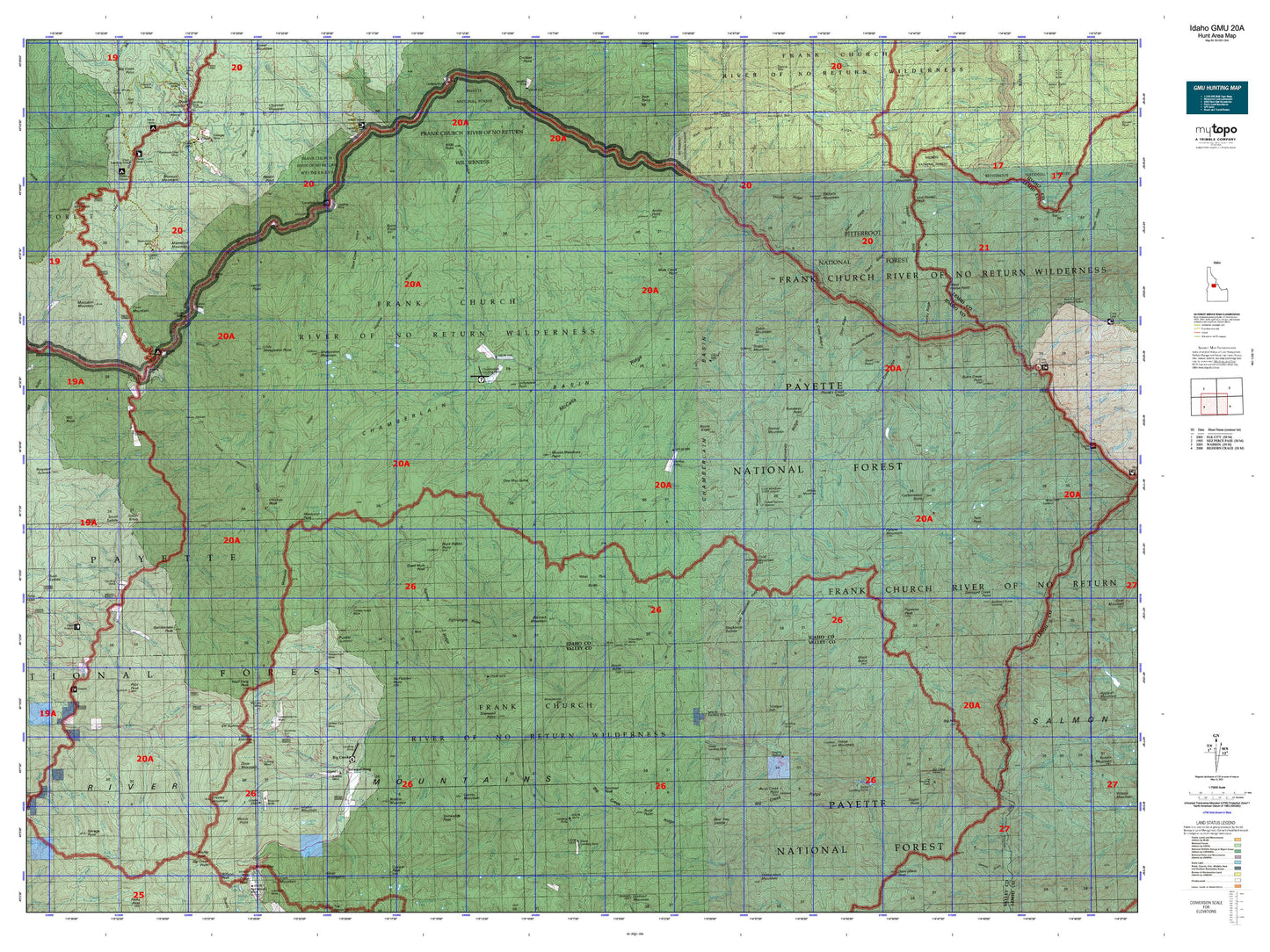
Hunting unit map of Idaho Game Management Unit 20A with topographic lines and unit boundaries. This topo map features UTM / MGRS and Latitude/Longitude grids, plus public land ownership. It comes folded on waterproof paper. Be fully prepared for your hunt with a MyTopo GMU map!.
This map contains the following named places: Abrams Height,Acorn Butte,Acorn Creek,Alder Creek,Arctic Creek,Arctic Point,Arctic Point Lookout,Badley Ranch,Bar Creek,Basin Creek,Basin Lake,Beal Cabin,Bear Creek,Beaver Creek,Beehive Creek,Belvidere Creek,Big Bear Creek,Big Blowout Creek,Big Buck Creek,Big Creek,Big Creek Point,Big Creek Work Center,Big Elkhorn Creek,Big Flat Creek,Big Hill,Big Mallard Creek,Big Mallard Creek Campground,Big Ramey Creek,Big Squaw Creek,Bismark Creek,Bismark Mountain,Black Butte,Black Creek,Black Lake,Blowout Mountain,Blue Ridge Cabin,Boise Creek,Bow Creek,Box Creek,Breeching Creek,Bruin Creek,Bruin Creek Campground,Buck Creek,Buck Point,Bull Creek,Burnt Creek,Burnt Knob,Butts Creek Point,Cabin Creek,Cabin Mountain,Calf Creek,Camp Creek,Canyon Creek,Cape Horn,Carlson Creek,Cave Creek,Center Mountain,Chalk Creek,Chamberlain Creek,Chamberlain Guard Station,Chicken Creek,Chicken Peak,China Creek,Churchill Creek,Clark Creek,Cliff Creek,Clover,Coin Creek,Cold Creek,Cold Meadows Forest Service Station,Cold Mountain,Cold Mountain Lookout,Comstock Creek,Conyer Creek,Copper Camp,Copper Creek,Corey Bar Campground,Cottonwood Butte,Cottonwood Creek,Cottonwood Lake,Cougar Creek,Cougar Peak,Cove Creek,Cove Mountain,Cove Ranch,Cow Corrals,Cow Creek,Coxey Creek,Crooked Creek,Crow Creek,Cub Creek,Curven Creek,Cutthroat Lake,Dame Creek,Dead Mule Peak,Deer Creek,Deer Park Creek,Dennis Lakes,Devils Teeth Creek,Devils Toe Creek,Diamond Creek,Diamond Point,Dillinger Creek,Disappointment Creek,Dismal Camp,Dismal Mountain,Ditch Creek,Dixie Mountain,Dixie Work Center,Doe Creek,Dog Creek,Dry Can Creek,Eagan Point,Eakin Cabin,Eakin Point,Edwardsburg,Elkhorn Bar Campground,Elkhorn Lookout,Estep Cabin,Farrow Mountain,Fish Lake,Flossie Lake,Forest Service Station,Fourway Junction,Frank Church-River of No Return Wilderness,Frog Lake,Frog Pond,Goat Point,Grandad Campsite,Grass Mountain,Greeley Mountain,Halfway House Campground,Hamilton Lakes,Hand Cabin,Hand Camp,Harrington Mountain,Hays Station,Hettinger Trailhead,Hida Point,Horse Creek Campsite,Horse Heaven,Horse Mountain,Hotzel Ranch,Hungry Creek Point,Jensen Cabin,Jersey Mountain,Jim Moore Place,Lantz Bar Campsite,Lantz Bar Forest Service Facility,Lantz Bar Recreation Site,Lemhi Lake,Lemhi Point,Lick Creek Trailhead,Lick Lake,Little Sheepeater Lake,Little Sheepeater Point,Lodgepole Point,Logan Lake,Logan Mountain,Lost Packer Lake,Lost Packer Peak,Mackay Bar,Mackay Bar Campground,Mammoth Mountain,Marble Mountain,McCoy Cabin,Mile Hi,Mile High Ranch,Moccasin Mountain,Moore Point,Moose Meadows Point,Mosquito Lake,Mosquito Peak,Mosquito Ridge Trailhead,Mount Eldridge,Mule Creek Point,No Name Creek,One Man Butte,Papoose Lake,Papoose Peak,Patrol Point,Pilot Peak,Pilot Peak Lookout,Profile Lake,Profile Peak,Pueblo Summit Trailhead,Rabbit Point,Rattlesnake Peak,Rhett Creek Campground,Rock Lake,Rocky Point,Root Ranch,Roots Knob,Round Mountain,Runaway Point,Rush Creek Point,Rush Creek Point Lookout,Salmon River Breaks Primitive Area,Salmon Wild and Scenic River,Sams Creek Campground,Sams Creek Recreation Site,Savage Point,Shake Cabin,Sheepeater Lake,Sheepeater Mountain,Smith Creek-Big Creek Trailhead,Smith Knob,Smith Knob Lookout,Smith Saddle Trailhead,Snowslide Peak,Stoddard Creek Lookout,Stoddard Creek Point,Stoddard Lake,Stonebraker Ranch,Stripe Mountain,Swamp Angel Lake,Swet Lake,Swet Lake Cabin,Swet Lake Pond,Swet Point,Telephone Camp,Thirteen Lakes,Thirteen Mountain,Trail Point,Tumbledown Bridge,Twin Lakes,Twin Peak,Vinegar Hill,Waugh Mountain,West Horse Point,Whitewater Campground,Whitewater Ranch,Willson Peak,Wolf Fang Peak,Wolfe Place