MyTopo
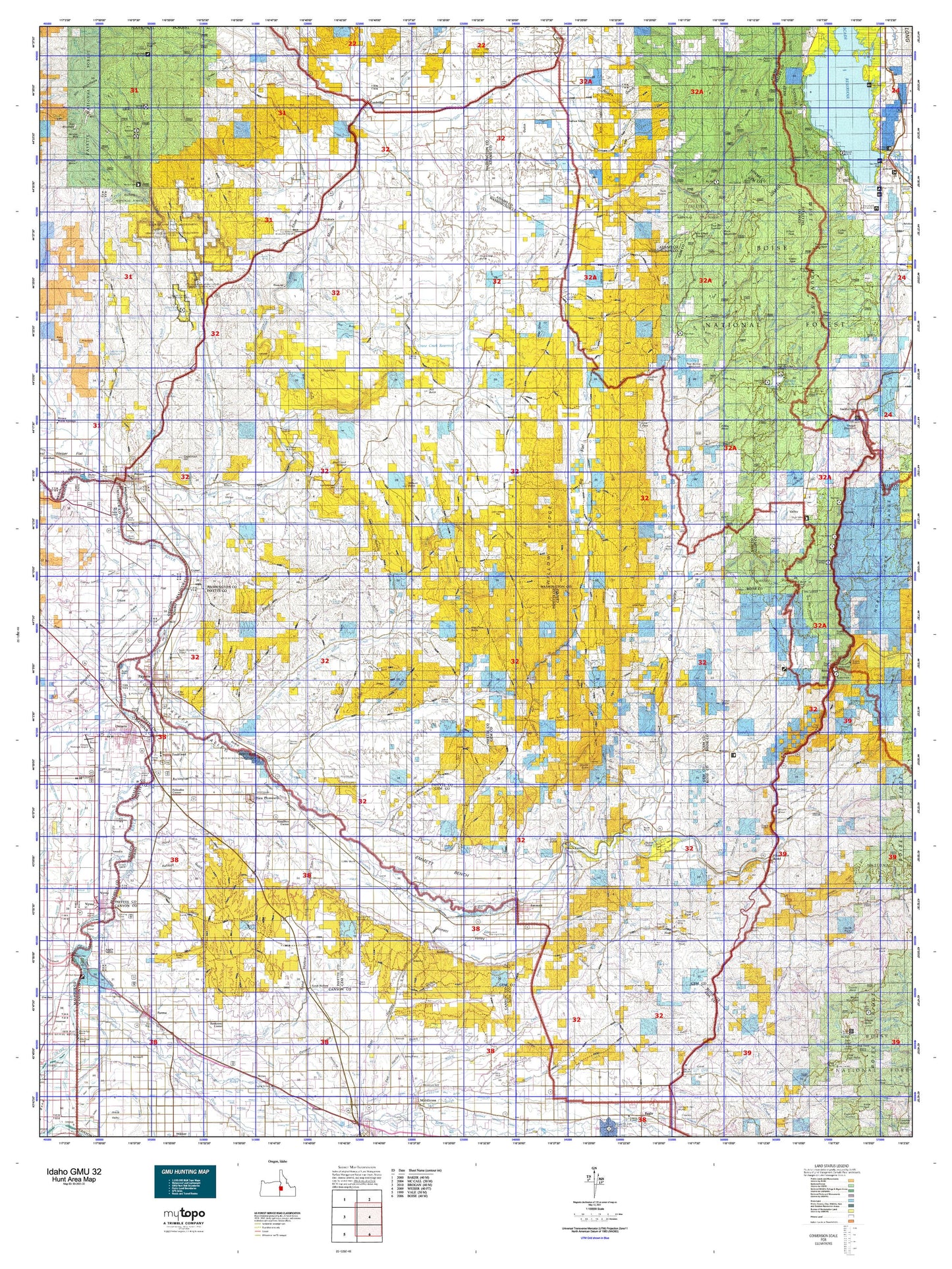
Idaho GMU 32 Map
Couldn't load pickup availability
Hunting unit map of Idaho Game Management Unit 32 with topographic lines and unit boundaries. This topo map features UTM / MGRS and Latitude/Longitude grids, plus public land ownership. It comes folded on waterproof paper. Be fully prepared for your hunt with a MyTopo GMU map!.
This map contains the following named places: 4 D J Farm,Aikman,Airport Pond Public Fishing Area,Alpine,Ammondo School,Amsco,Annex,Ant Butte,Antelope Campground,Arcadia,Arcadia Lake,Avimor,Banks,Banks Campground,Banks Recreation Site,Barton,Barton Reservoir,Becker Ponds,Beck-Kiwanis Park,Beech Lake,Beer Bottle Crossing,Ben Ross Reservoir,Bettis Reservoir,Big Eddy,Big Eddy Campground,Black Canyon,Black Canyon Reservoir,Blacks Bridge Access Area,Blue Lake,Bogus Basin State Park,Bramwell,Bread Loaf Rock,Brownlee,Buck Mountain,Buckingham,Butte Ranch,Buttermilk Slough,Cambridge,Canyon Campground,Castle Rock,Catrock School,Central Park,Claude,Cold House,Cold Springs Campground,Collier Peak,Concrete,Cooper School,Cove School,Coyote Rock,Cozy Corners School,Crane,Crane Creek Reservoir,Crystal,Crystal School,Deer Creek School,Del Monte,Diamond,Dobson Ranch,Dry Buck Mountain,Dry Buck School,Eastside Campground,Eastside Park,Eastside School,Echo Dell School,Eiffie,Emmett,Emmett Plaza,Enterprise School,FAA Radar Site,Fairchild Reservoir,Falks,Feltham,Fletcher Butte,Fort Wilson,Four Bit Summit,Freezeout Hill,French,French Corner,Friday Butte,Fruitland,Gabes Bathtub,Gabes Peak,Gardena,Gardena Access Area,Gayway Corner,Gem County,Granger Butte,Granite Peak,Greyhound Bus Station Ontario,Groner Reservoir,Gross,Hamilton Corner,Hangman Tree,Hidden Lake,High Valley,High Valley Ranger Station,High Valley School,Hillsdale,Hillsdale School,Hitt Peak,Hog Cove Butte,Hog Creek Butte,Hollywood Point Campground,Home Lake,Horseshoe Bend,Horseshoe Bend Mill Pond Public Fishing Area,Howell,Hyline Hall,Indian Jakes,Indian Mountain,Indian Mountain Lookout Station,Indian Valley,Ingard,Jenkins Creek Reservoir,Jenness,Joes Butte,Josephson,Justrite Campground,Kiawanis Campground,King Hill,Kiwanis Park,Laxson Park,Letha,Lions Park,Little Banks Island Wildlife Habitat Area,Little Butte,Little Crane Creek Reservoir,Little Rock,Lone Pine Lake,Lookout Peak,Lost Lake,Lower Crystal School,Malheur County Fairgrounds,Malheur Junction,Mann Creek Guard Station,Mann Creek Reservoir,Mann Creek State Park,Marsh,Midvale,Midvale Hill,Mill Creek Ranger Station,Montour,Mosquite,Mount Maria,Mud Lake,Mud Lake Cow Camp,New Plymouth,Nyssa,Nyssa River Park Boat Ramp,Nyssa Wastewater Treatment Plant,Ola,Ontario,Ontario Safety Rest Area,Ontario State Park,Ontario State Park Boat Ramp,Ontario Water Treatment Plant,Oregon Slope,Oregon Slope Community Hall,Paddock Valley Reservoir,Palisades Corner,Paradise Campground,Parma,Payette,Payette County,Payette Heights,Payette Junction,Payette River Wildlife Management Area,Pearl,Penn Slough,Picket Corral,Pintail Pond,Plaza,Plaza Road Bridge Access Area,Pleasant View School,Poison Timber Point,Potato Knob,Potters Pond,Presley,Presley Station,Prospect Peak,Raft Lake,Ramey,Rebecca,Regan Butte,Riley Butte,River Park,Roberts Access Area,Rock Lake,Rookstool Corner,Rosedale Memorial Park,Roswell,Sage Hen Campground,Sage Hen Dam Recreation Site,Sage Hen Reservoir,Sagebrush Hill,Salubria,Sand Hollow,Sand Hollow Wildlife Habitat Area,Shirts Lake,Siphon Lakes,Skein Lake,Snowbank Mountain,Soulen Reservoir,South Mountain,Spring Creek Campground,Squaw Butte,Star Butte,Star Lane Pond Public Fishing Area,Star Lane Wildlife Habitat Area,Sugarloaf,Sweet,Swinging Bridge Campground,Takatori Access Area,Third Fork Guard Station,Third Fork Project Camp,Timber Butte,Treasure Valley Ball Park,Tree Spring Mountain,Tripod Peak,Tripod Peak Lookout,Tripod Reservoir,Tripod Summit,Twin Sisters,Van Duesan Ranch,Vickery Access Area,Walker Mill,Washoe,Weiser,Weiser Junction,Wilburn Butte,Williams Creek Summit Home Area,Willow Creek Reservoir,Wilson Peak,Wood