MyTopo
Idaho GMU 36A Map
Couldn't load pickup availability
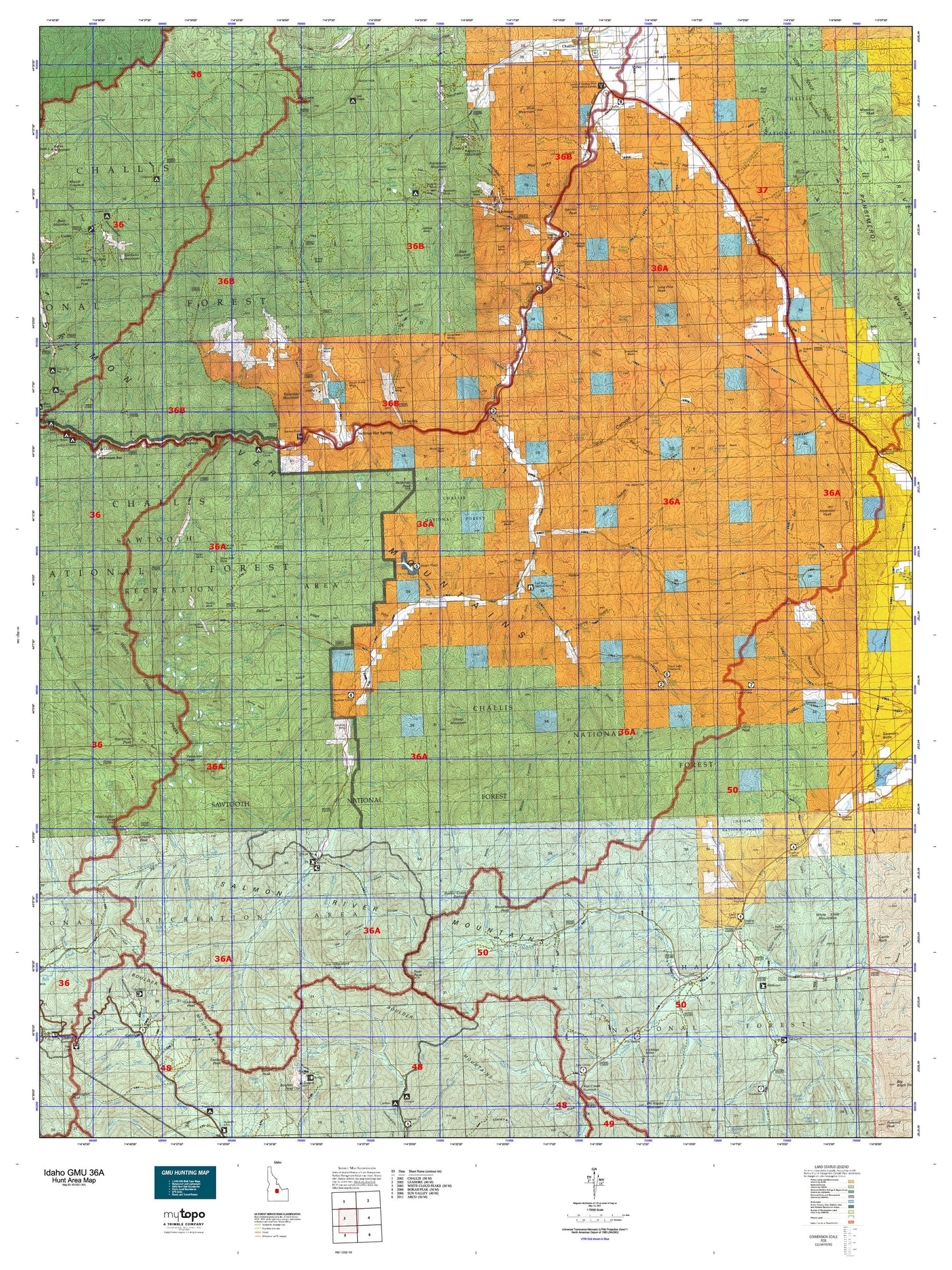
Hunting unit map of Idaho Game Management Unit 36A with topographic lines and unit boundaries. This topo map features UTM / MGRS and Latitude/Longitude grids, plus public land ownership. It comes folded on waterproof paper. Be fully prepared for your hunt with a MyTopo GMU map!.
This map contains the following named places: Alder Creek,Alta Creek,Anderson Peak,Aspen Creek,Bachelor Mountain,Badger Creek,Bady Creek,Bailey Creek,Baker Creek,Baker Lake,Bald Mountain,Bartlett Creek,Basin Creek,Bayhorse,Bayhorse Campground,Bayhorse Creek,Bayhorse Lake,Bayhorse Recreation Site,Bear Creek,Beaver Creek,Bible Back Mountain,Big Boulder Creek,Big Boulder Lakes,Big Fall Creek,Big Fall Creek Lake,Bighorn Creek,Birch Creek,Blackmon Peak,Blind Creek,Blue Mountain,Bluett Creek,Boorn Lakes,Boulder Chain Lakes,Boulder Chain Lakes Creek,Boulder Lake,Boundary Creek,Bowery Creek,Bowery Creek Trailhead Camp,Bowery Guard Station,Bowery Peak,Bradshaw Creek,Broken Ridge Creek,Broken Wagon Creek,Bruno Creek,Buckskin Creek,Burnt Aspen Creek,Burnt Creek,Buster Lake,Cabin Creek,Calkins Lake,Camp Creek,Carbonate Creek,Cash Creek,Castle Lake,Challis Division,Chamberlain Creek,Cherry Creek,Chicken Creek,Cirque Lake,City of Clayton,Clayton,Clayton Ranger Station,Coal Camp Fork,Coal Creek,Cold Creek,Cornice Lake,Corral Basin Creek,Corral Creek,Cove Lake,Cow Camp,Coyote Creek,Crater Lake,Croesus Peak,Crystal,Custer County,Custer County Fairgrounds,Custer Lookout,Custer Number 1 Campground,Deep Creek,Deep Creek Recreation Site,Deer Creek,Deer Lakes,Dike Lake,Easley Peak,East Fork Big Lost River,East Fork Bureau of Land Management,East Fork Herd Creek,East Fork School,East Pass Creek,Eightmile Campground,Eightmile Creek,Elevenmile Creek,Emerald Lake,Fall Creek,Fall Creek Recreation Site,Fannys Hole,First Creek,Fivemile Creek,Fourth of July Creek,Fourth of July Lake,Fox Creek,French Creek,Frog Lake,Frog Lakes,Galena,Galena Peak,Garden Creek,Gardner Creek,Gentian Lake,Germania Creek,Germer Park,Glacier Lake,Gladiator Creek,Glassford Peak,Goat Lake,Gooseberry Creek,Grasshopper Creek,Greylock Campground,Gunsight Creek,Gunsight Lake,Hatchet Lake,Headwall Lake,Hemingway-Boulders Wilderness,Herd Creek,Herd Lake,Herd Peak,Hidden Lake,Hole-in-Rock Creek,Holman Creek,Holman Creek Campground,Hoodoo Lake,Hook Lake,Horse Basin Creek,Horse Creek,Hourglass Lake,Hummock Lake,Hunter Creek,Ibex Creek,Island Lake,Jack Creek,Jerry Peak,Jim Creek,Jim McClure-Jerry Peak Wilderness,Jimmy Smith Creek,Jimmy Smith Lake,Jimmy Smith Lake Public Fishing Area,Juliette Creek,Kane Creek,Kent Peak,Keystone Mountain,Kinnikinic Creek,Lake Creek,Land of the Yankee Fork Historic Area Interpretive Center,Last Chance Creek,Lavine Creek,Lee Peak,Leg Creek,Lime Creek,Little Bayhorse Lake,Little Boulder Creek,Little Boulder Transfer Camp,Little Burnt Creek,Little Frog Lake,Little Kane Creek,Little Redfish Lake,Little Wickiup Creek,Livingston Creek,Livingston Mill,Livingston Mine Power Plant,Lodgepole Lake,Lone Pine Creek,Lone Pine Peak,Lonesome Lake,Long Tom Creek,Lyon Creek,MacRae Creek,Marco Creek,Martin Creek,McDonald Creek,McGowan Creek,McKay Creek,Meridian Creek,Meridian Peak,Merriam Peak,Milk Lake,Mill Creek,Mill Creek Campground,Mill Creek Summit,Mosquito Creek,Mountain Meadow Creek,Mud Creek,Neck Lake,Noisy Lake,North Fork Lake,Phi Kappa Campground,Phyllis Lake,Potaman Peak,Quartzite Lake,Quiet Lake,Ramshorn Mountain,Red Hill,Red Lake,Rock Lake,Ryan Peak,Sapphire Lake,Saturday Mountain,Sawtooth National Forest Trailhead,Scoop Lake,Scree Lake,Shallow Lake,Sheep Lake,Sheep Mountain,Shelf Lake,Six Lakes,Slide Lake,Sliderock Lake,Snow Lake,Snyder Springs Picnic Area,State of Idaho,Sullivan Lake,Swim Lake,Table Mountain,Tin Cup Lake,Tiny Lake,Torreys,Torreys Hole Floatboat Access,Torreys Hole Recreation Site,Walker Lake,Washington Lake,Washington Peak,Waterdog Lake,White Clouds Wilderness,Wildhorse Guard Station,Willow Lake,Window Lake