MyTopo
Idaho GMU 37A Map
Couldn't load pickup availability
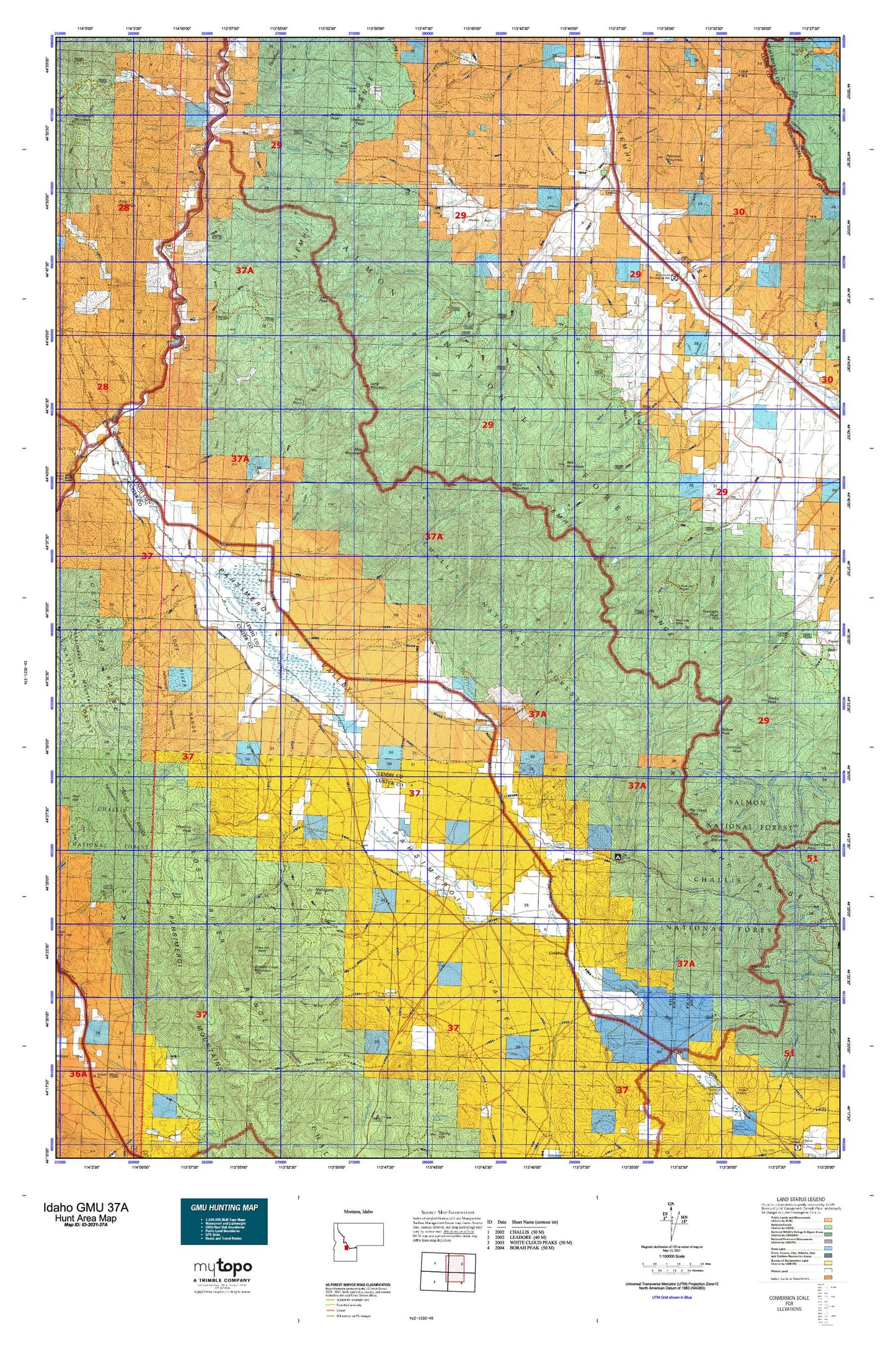
Hunting unit map of Idaho Game Management Unit 37A with topographic lines and unit boundaries. This topo map features UTM / MGRS and Latitude/Longitude grids, plus public land ownership. It comes folded on waterproof paper. Be fully prepared for your hunt with a MyTopo GMU map!.
This map contains the following named places: 83235,83465,Alder Creek,Allison Creek,Anderson Spring,Andrews Spring,Apple Creek,Armstrong Dam,Basin Creek,Basin Lake,Bates Gulch,Bear Creek,Bear Valley Creek,Bear Valley Lakes,Berg-Green Gulch,Big Creek,Big Creek Camp,Big Creek Campground,Big Creek Peak,Big Creek School,Big Eightmile Campground,Big Gulch,Black Canyon,Blind Fork Trail Creek,Blue Jay Mine,Boulder Flat,Bray Creek,Buck Creek,Buffalo Skull Lake,Bull Creek,Bull Spring,Bull Summit Waterhole,Burnt Spring Gulch,Cabin Creek,Carol Creek,Cedar Gulch,Challis Division,Climb Creek,Cold Creek,Cooney Canyon,Cooper Creek,Copper Basin,Copper Creek,Corbett Spring Number 1,Cow Creek,Crane Basin,Cronks Canyon,D C Gulch,Dairy Creek,Dairy Lake,Dead Cat Canyon,Deer Creek,Devils Basin,Devils Canyon,Devils Lake,Ditch Creek,Donkey Creek,Doublespring Creek,Doublespring Ranch,Dry Canyon,Dry Creek,Dry Gulch,East Fork Hayden Creek,East Fork Morgan Creek,East Fork Patterson Creek,Elbow Creek,Elk Bend,Elk Bend Fire Protection District Station 1,Elk Bend Fire Protection District Station 2,Elk Bend Fire Protection District Station 4,Ellsworth-Lower Dam,Ellsworth-Upper Dam,Ennis Gulch,Everson Creek,Everson Lake,Ezra Creek,Falls Creek,Ferry Creek,First Basin,Flatiron Mountain,Flying Joseph Ranch Airport,Ford Creek,Fred and Mary Draw,Goat Lake,Goldburg,Goldburg Creek,Goldburg School,Graves Spring,Grouse Creek,Grouse Creek Lake,Grouse Creek Mountain,Gunsight Peak,Hat Creek,Hayden Basin,Hayden Creek,Hayden Creek Access Area,Hayden Creek Rearing Ponds,High Spring,Hillside Creek,Hodges Spring,Horse Spring,Hot Spring,Ima Mine,Inyo Creek,Iron Creek,Iron Creek Cemetery,Jack Smith Gulch,John Short Springs,Junction Peak,Kadletz Creek,Lake Creek,Lake Fork,Lawson Creek,Lem Peak,Lemhi,Lemhi Post Office,Lemhi Range,Lemhi River Salmon Trap,Little Dry Gulch,Little Mill Creek,Little Sawmill Creek,Lone Pine Ranch,Long Mountain,Long Ridge,Mahogany Creek,Mahogany Hill,May,May Airport,May Cemetery,May Mountain,McFarland Access Area,McKim Creek,McNutt Creek,Meadow Creek,Meadow Peak,Mill Creek,Mill Creek Lake Dam,Mill Lake,Mill Mountain,Mogg Creek,Mogg Mountain,Morgan Creek,Morse Creek,Mud Creek,Mulkey Gulch,Napo Canyon,Napo Spring,North Basin,North Fork Big Creek,North Fork Cow Creek,North Fork Lawson Creek,North Fork McKim Creek,North Fork Morgan Creek,Opal Spring,Pahsimeroi Hatchery,Pahsimeroi Volunteer Fire Department,Paradise Creek,Park Fork,Patterson,Patterson Creek,Patterson Division,Patterson Elementary School,Payne Creek,Peterson Creek,Phantom Creek,Poison Creek,Poison Peak,Porcupine Creek,Prospect Creek,Quake Lake,Ramsey Mountain,Rattlesnake Spring,Ray Lode Mine,Red Point,Reese Creek,Ringle Creek,Rock Spring,Rock Spring Canyon,Rye Grass Creek,Sheep Pen Basin,Shep Creek,Short Creek,Snowslide Creek,South Fork Big Creek,South Fork Lawson Creek,South Fork Poison Creek,South Fork Yearian Creek,Spring Gulch,Squaw Creek,Stinking Creek,Stroud Creek,Stroud Lake,Struggle Gulch,Sulphur Creek,Swanson Gulch,Swartz Creek,Swauger Ranch,Table Mountain,Tater Creek,Tobias Creek,Trail Creek,Wade Creek,Walter Creek,Warm Spring Creek,Watson Peak,West Fork Big Creek,West Fork Hayden Creek,Wino Basin,Wood Ranch,Wright Creek,Yearian Creek,Yellow Peak,Zeph Creek