MyTopo
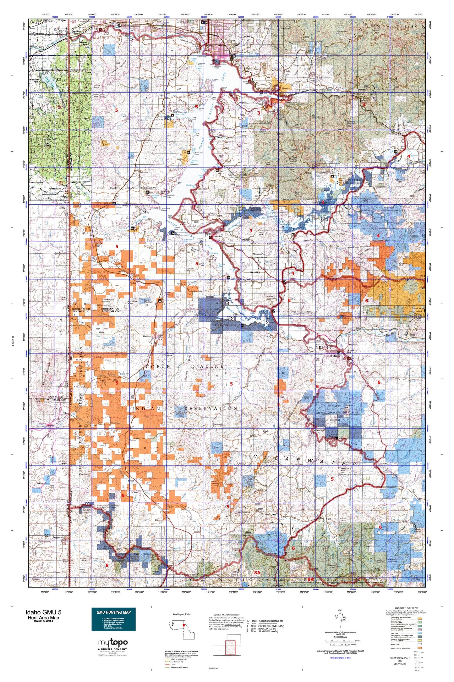
Idaho GMU 5 Map
Couldn't load pickup availability
Hunting unit map of Idaho Game Management Unit 5 with topographic lines and unit boundaries. This topo map features UTM / MGRS and Latitude/Longitude grids, plus public land ownership. It comes folded on waterproof paper. Be fully prepared for your hunt with a MyTopo GMU map!.
This map contains the following named places: Al Vanderpool Picnic Area,Alder Creek,Alexander McDowell Rest Area,Amwaco,Anderson Lake,Beauty Bay Picnic Area,Beauty Creek Campground,Beaver Ponds,Beedle Point,Bell Bay Campground,Bellgrove,Bells Lake,Benewah,Benewah County,Benewah Lake,Black Lake,Black Rock,Blackwell Hill,Blossom Mountain,Blue Lake,Blue Point Public Boat Ramp,Boothe Park Public Boat Ramp,Browns Point,Cable Peak,Camp Easterseal,Camp Easton,Camp Four Echoes,Cardwell,Carill Peak,Carlin Grange,Cave Lake,Cellar Point,Chaats'alalqs Grove,Charles Butte,Charlottes Webb,Chatcolet,Chatcolet Lake,Chat'u'washa'lqs Bluff,Cherry Hill,Chetkwe'lkw'l Meadow,Chief MOC-TEL-ME Rest Area,Chippy Point,Chl'ach'alqw Landing,Ch'mi'wes Flat,City of Fernan Lake Village,City of Harrison,City of Parkline,City of Plummer,City of Saint Maries,City of Tensed,City of Worley,Coeur d'Alene,Coeur d'Alene Division,Coeur d'Alene Indian Tribal Headquarters,Coeur d'Alene Lake,Coeur d'Alene Reservation,Coeur d'Alene River Wildlife Management Area,Conkling Park,Conkling Point,Cottonwood Peak,De Smet,Donavons Point,Driftwood Point,Eagle Lookout,Eagle Peak,East Point,Easterseal Camp,Eddyville,Elk Mountain,Elk Patrol Lookout,Emida,Emida Peak,Farmers Union,Fernan Hill,Fernan Lake,Fernan Lake Village,Fourth of July Summit,Gasser Point,Gibbs,Goose Heaven Lake,Goulds Landing,Grange Park,Grassy Mountain,Harlow Point,Harrison,Harrison Boat Landing,Harrison City Park,Harrison Division,Harrison Slough,Hawleys Landing,Heyburn State Park,Heyburn Youth Camp,Hidden Lake,Hnchch'li Lake,Hnmlmulsh Grove,Hnp'ekwle'n Meadow,Hnpetptqwe'n,Hn'ya)pqi'nn,Hollywood,Indian Mountain,Initial Peak,Initial Peak Lookout House,John Point,Kern Butte,Khwele' Grounds,Killarney Lake,Killarney Lake Picnic Area,Killarney Mountain,Kings Peak,Kootenai County,Lacon,Lamb Peak,Lane,Len Landing,Liberty Butte,Lindstrom Peak,Loffs Bay Access,Lotus,Lukwle' Mountain,Luther,Lyndale Landing,Lyondale,Mae McEuen Playfield,Mashburn,Mason Butte,McCartney Butte,McDonald Point,Meadowhurst,Medicine Lake,Medicine Mountain,Medimont,Memorial Field,Mica,Mica Bay Access Area,Mica Bay County Campground,Mica Peak,Midtown Shopping Center,Milltown,Mil'o'lmkhw Point,Mineral Ridge Boat Ramp,Mineral Ridge Picnic Area,Minkler Mountain,Moses Mountain,Mount Coeur D Alene Lookout,Mount Coeur D Alene Picnic Area,Mount Coeur d'Alene,Mountain Tree Historic Site,Mowry,Mowry State Park,Mozart,Mullen Trail Park Historical Monument,Ne'atsqhaqhst'm Flat,Negro Brown Hill,Nehchen Bluff,Ni'lukhwalqw Gap,Ni'nsi' Meadow,Ni'washalqs Spur,North Cape,North South Ski Bowl,Northview Plaza,Parkline,Pedee,Peterson Point,Petit Peak,Pilot Rock Sandpoint,Pleasant View,Plummer,Plummer Butte,Plummer Division,Plummer Junction,Plummer Peninsula,Porrett Lake,Potlatch Hill,Quqw'li'te'lps Grove,Rainy Hill,Rainy Hill Campground,Rainy Hill Guard Station,Ramsdell,Red Horse Mountain,Reynolds Point,Rich Hill,Riverdale,Rockford Bay,Rockford Point,Rocky Point,Rose Lake Wildlife Habitat Area,Round Lake,Round Lake Access Area,Round Top,Rover,Saint Maries,Saint Maries Country Club,Saint Maries Division,Saint Maries Peak,Saint Maries Ranger Station,Saint Maries River Access,Saint Maries River Access Area,Saint Maries Wildlife Management Area,Sanders,Setters,Sharp Top,Shasta Butte,Shay Hill,Shoeffler Butte,Silvertip Landing,Smaq'wqn Hill,Soloa Peak,Spokane Point,Springston,Sq'wdusmn Bench,Sqwe'mu'lmkhw,Stevens Point,St'uts'te'wes Point,Swan Lake,Swan Peak,Swewla'qn Grove,Talbot Hill,Taqhalqs Hill,Tensed,Tensed Division,Thompson Lake,Thompson Lake Sportsman Access,Threemile Point,Ts'e'ltm Rock,Tubbs Hill,Turner Peak,Twin Peaks,Tyson Peak,Warners Mountain,Watt Hill,Wolf Lodge,Worley,Worley Division,Worley Mountain,Zehm Hill


