MyTopo
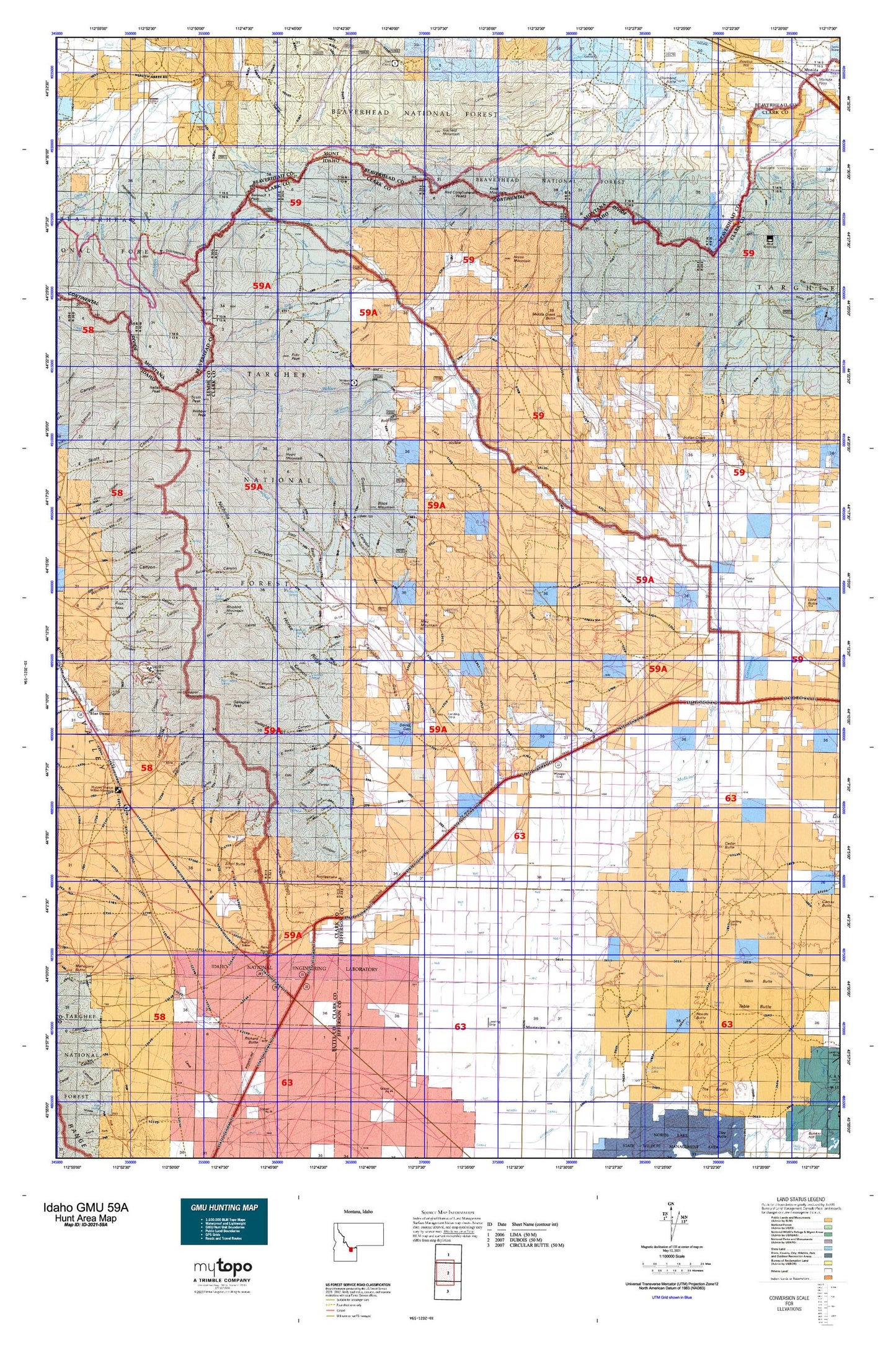
Idaho GMU 59A Map
Couldn't load pickup availability
Hunting unit map of Idaho Game Management Unit 59A with topographic lines and unit boundaries. This topo map features UTM / MGRS and Latitude/Longitude grids, plus public land ownership. It comes folded on waterproof paper. Be fully prepared for your hunt with a MyTopo GMU map!.
This map contains the following named places: 83435,Anderson Gulch,Antelope Lakes,Antelope Spring,Argora,Bannack Pass,Bare Canyon,Bear Canyon,Bear Wallow Canyon,Beartrap Creek,Beaverhead Mountains,Big Spring,Big Spring Creek,Birch Creek Valley,Black Canyon,Black Horse Canyon,Black Mountain,Bloom Canyon,Blue Canyon,Blue Canyon Spring,Blue Creek,Blue Creek Spring,Bluebird Mountain,Boulder Spring,Broad Hollow,Buckboard Gulch,Buckhorn Canyon,Buffalo Creek,Buffalo Spring,Cabin Creek,Campbell Gulch,Cedar Butte,Cedar Butte Well,Chandler Canyon,Chandler Spring,Clark County,Cold Creek,Cole Canyon,Continental Spring,Copper Mountain,Corral Canyon,Corral Creek,Cow Camp,Cow Creek,Crooked Creek,Crystal Gulch,Dead Horse Creek,Deadman Canyon,Deadman Creek,Deadman Creek Station,Deadman Lake,Deep Creek,Deep Creek Cow Camp,Deer Canyon,Devils Gap,Diamond Butte,Divide Creek,Divide Creek Lake,Dry Creek,East Fork Big Beaver Creek,East Fork Indian Creek,East Modoc Creek,Edie Creek,Edie Ranch,Edie Spring,Fritz Creek,Fritz Peak,Fulwider Gulch,Gallagher Canyon,Gallagher Peak,Garfield Mountain,Goddard Cemetery,Grouse Canyon,Heart Canyon,Heart Mountain,Hoolie Springs,Horse Creek,Horse Mountain,Horse Ridge,Indian Creek,Indian Creek Butte,Irving Creek,Italian Peak,Juniper Gulch,Kelly Canyon,Kitty Spring,Knob Mountain,Knoll,Lake Creek,Lake Hollow,Left Fork Middle Creek,Lidy Hot Springs,Lima Peaks,Limestone Gulch,Little Beaver Creek,Little Deadman Creek,Lone Pine Spring,Long Canyon,Lower Crystal Spring,Lower Deep Creek Spring,Maud Mountain,McNeary Creek,Meadow Creek,Medicine Lodge Creek,Middle Creek,Middle Creek Butte,Middle Creek Cow Camp,Middle Modoc Creek,Mill Fork,Monteview,Monteview Post Office,Myers Creek,Needle Butte,Nicholia Canyon,Nicholia Creek,North Fork Fritz Creek,North Fork Snaky Canyon,North Fork Webber Creek,Park Dam,Peterson Canyon,Pine Creek,Pioneer Pass,Poison Creek,Poison Gulch,Rattlesnake Point,Red Canyon,Red Conglomerate Peaks,Reno Ditch,Reno Gulch,Reno Point,Reno Ranch,Richard Butte,Robertson Gulch,Rock Creek,Rocky Canyon,Rocky Creek,Round Timber Spring,Salt Creek,Sawmill Creek,Sawmill Spring,Scott Butte,Scott Peak,SE SE Section 16 Mine,Seybold Spring,Shamrock Gulch,Shamrock Spring,Shineberger Creek,Slate Basin,Small,Snaky Canyon,South Fork Deep Creek,South Fork Fritz Creek,South Fork Webber Creek,Spring Canyon,Spring Creek,Spring Hollow,Stinking Spring,Sun Number 12 Mine,Swamp Creek,Tepee Draw,The Bull Pen,The Thumb,Three Springs,Upper Crystal Spring,Warm Creek,Warm Springs,Warm Springs Creek,Webber Creek,Webber Peak,West Clark Division,West Fork Big Beaver Creek,West Fork Indian Creek,West Jefferson Fire Station,West Modoc Creek,Winsper,Wood Canyon