MyTopo
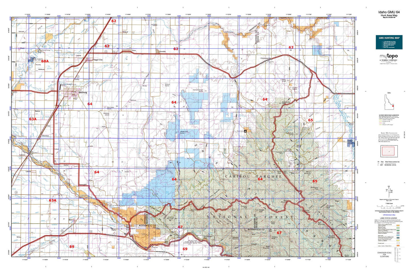
Idaho GMU 64 Map
Couldn't load pickup availability
Hunting unit map of Idaho Game Management Unit 64 with topographic lines and unit boundaries. This topo map features UTM / MGRS and Latitude/Longitude grids, plus public land ownership. It comes folded on waterproof paper. Be fully prepared for your hunt with a MyTopo GMU map!.
This map contains the following named places: 83436,83440,83448,83451,83460,Anderson Canal,Archer,Argument Ridge,Baldy Knoll,Beartrap Canyon,Bertha Rock,Bex Spring,Big Hole Mountains,Big Island,Birch Creek,Bitters Butte,Blacktail Creek,Blacktail Pass,Blanche Rock,Brown Bear Creek,Brown Bear Mine,Browning Creek,Buck Spring,Buckhorn Spring,Bucks School,Buckskin Morgan Ridge,Burton,Burton Cemetery,Butler Island,Byrne,Calamity Creek,Canyon Creek Butte,Canyon Creek Canal,Carlton Creek,Carlton Cutoff Trail,Castle Lake,Castle Rock,Chicken Peak,City of Newdale,City of Rexburg,City of Rexburg Ditch,City of Ririe,City of Sugar City,City of Teton,Clark Edwards Canal,Clarke Creek,Clements Spori Ditch,Clementsville,Coalmine Canyon,Coalmine Creek,Cold Spring,Conner Spring,Coyote Canyon,Crooked Creek,Crystal Lake,Dora Spring,Dry Canyon,Eagle Rock Canal,East Farnes Mountain,East Farnes Mountain Spring,East Fork Hilton Creek,East Labelle Canal,East Madison Division,East Teton Canal,Elbow of Moody Creek,Elk Flat,Elk Flat Fork,Elkhorn Warm Spring,Enterprise Canal,Farmers Friend Canal,Farnes Mountain,Fish Creek,Flat Hollow,Gale,Garner Creek,Garns Mountain,Gilbert Ditch,Graham Hollow,Graham Spring,Grandview Point,Hart,Hawley Gulch,Hawley Gulch Ranger Station,Hawley Spring,Hawley Warm Spring,Heise,Heise Hot Springs,Hell Hole Canyon,Herbert,Hibbard,Hillman Creek,Hillman Mine,Hilton Creek,Hinckley,Hinckley Creek,Hot Springs,Idaho Ridge,Irene Creek,Island Canal,Island Ward Canal,Jensen,Jensen Creek,Jolley,KADQ-FM (Rexburg),Kelly Canyon,Kelly Canyon Ski Area,Kelly Mountain,Kelly Spring,Kirkham Hollow,KRXK-AM (Rexburg),KRXK-FM (Rexburg),Labelle,Leatham Dam,Lenroot Canal,Liars Peak,Limekiln Canyon,Little Burns Canyon,Long Hollow,Lookingglass Creek,Lookout Mountain,Lorenzo,Lost Spring,Lowder Slough,Lufkin Spring,Lyman,Lyons Creek,Madison County,Mark,Marlow Creek,Mikesell Mine,Milo,Milo Cemetery,Moody,Moody Creek,Moody Creek Access Area,Moody Meadow,Moody Swamp,Morning Glory Mine,Mud Creek,Mud Springs,Neville Spring,Newdale,North Fork Canyon Creek,North Moody Creek,North Rudy Canal,Open Canyon,Packsaddle Basin,Packsaddle Lake,Packsaddle Mine,Packsaddle Spring,Parkinson,Pincock Garner Ditch,Pincock Hot Springs,Piney Pass,Piney Peak,Pintar Canyon,Pintar Mine,Poison Flat,Pole Canyon,Pony Creek,Poplar,Porcupine Creek,Prospect Peak,Rattlesnake Point,Red Butte,Reid Canal,Relay Ridge,Rexburg,Rexburg Canal,Rexburg Cemetery,Rexburg Division,Rexburg-Madison County Airport,Rigby Hospital,Riley Ditch,Ririe,Ririe Cemetery,Ririe Division,Ruby Creek,Rudy,Rudy Canal,Ryan Peak,Salem,Salem Canal,Sawmill Gulch,Sheep Creek,Sidehill Ditch,Sommers Butte,South Branch Rexburg Canal,South Fork Canyon Creek,South Fork Packsaddle Creek,South Moody Creek,South Rigby Canal,South Teton River,Spooky Canyon,Spori Canyon,Spring Creek,State Creek,Station Gulch,Stinking Spring,Stinking Spring Canyon,Sugar City,Sugar City Cemetery,Sugar City Division,Sunnydell,Sunnydell Canal,Superior Mine,Susies Nipple,Sutton Cemetery,Sweetwater Canyon,Table Rock Canyon,Targhee National Forest,Temple Peak,Teton,Teton Canal,Teton Cemetery,Teton Island Canal,Texas Slough Canal,Thornton,Thousand Springs Valley,Tie Bend,Twin Peaks,Walker,Warm Creek,Warm Slough,Warm Slough Access Area,Webster Butte,West Farnes Mountain,Westfield Branch Canal,Wheaton Mountain,White Owl Butte,Windy Ridge,Wolverine Creek,Woodmansee Johnson Canal,Woods Crossing,Wright Creek