MyTopo
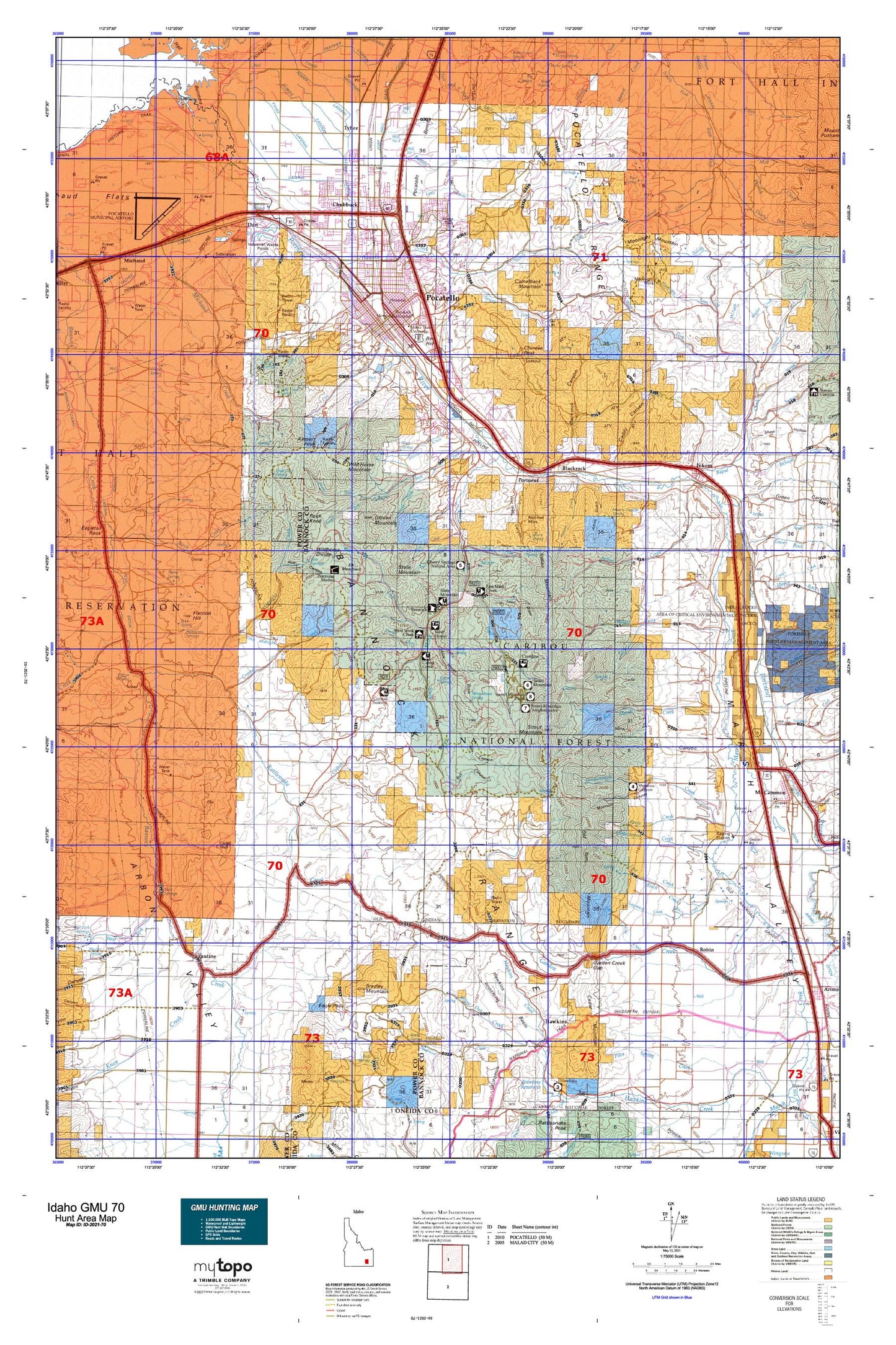
Idaho GMU 70 Map
Couldn't load pickup availability
Hunting unit map of Idaho Game Management Unit 70 with topographic lines and unit boundaries. This topo map features UTM / MGRS and Latitude/Longitude grids, plus public land ownership. It comes folded on waterproof paper. Be fully prepared for your hunt with a MyTopo GMU map!.
This map contains the following named places: 83201,83209,83212,83214,83245,Alameda,Alameda Plaza,Ames Gulch,Ammon Park,Arbon Division,Arbon Valley,Arbon Valley Census Designated Place,Baker Lateral,Bannock County,Bannock County Fairgrounds,Bannock Guard Station,Bannock Regional Medical Center Heliport,Barclay Creek,Batiste Springs,Bell Marsh Creek,Big Fir Picnic Area,Big Flat,Birch Creek,Blackrock,Blackrock Canyon,Blind Spring,Blind Spring Draw,Bonneville Park,Box Canyon,Bradley Mountain,Buck Creek,Buffalo Creek,Bull Canyon,Buttrey-Osco Family Center,Caddy Canyon,Caldwell Park,Camelback Mountain,Camp Tendoy,Campbell Creek,Caribou Ski Area,Cedar Mountain,Cherry Springs Campground,Cherry Springs Campground Picnic Area,Chimney Creek,Chinese Peak,Chubbuck,Church Lateral,City Creek,City of Chubbuck,City of Inkom,City of Pocatello,Clifton Creek,Corral Creek,Corral Spring,Cottonwood Creek,Covet Lateral,Crane Creek,Crystal,Crystal Creek,Cusick Creek,Cutler Creek,Dairy Creek,Dead Cow Spring,Deadwood Creek,Deer Pass Gulch,Doe Creek,Don,Dorys Canyon,Dry Canyon,Dry Creek,DuBois Lateral,Eagle Pass,East Fork Mink Creek,Elk Meadows,Elkhead Ranch,Ellis Creek,Facer Lateral,Fairview Park,Flatiron Hill,Foothill Plaza,Fort Hall Canyon,Fort Hall Mine,Fort Hall Reservation,Fort Hall Spring,Freckleton Park,Garden Creek,Garden Creek Gap,Gibson Jack Creek,Gibson Mountain,Goodenough Creek,Green Canyon,Hagler Creek,Havenor Lateral,Havenor Siphon,Hawkins,Hayes Lateral,Hooker Lateral,Horse Lake,Howard Mountain,Hyland Park,Indian Cemetery,Indian Creek,Indian Mountain,Indian Rocks State Park,Inkom,Inkom Cemetery,Inkom Division,Inman Creek,Jackson Creek,Johnny Creek,Justice Park,Kinney Creek,Kinport Peak,Knox Canyon,Knox Creek,Lawrence Creek,Lead Draw,Little Gap Creek,Little Midnight Creek,Little Pocatello Creek,Lost Creek,Lower Rock Creek,Marsh Creek,Marsh Valley,Martin Lateral,McNabb Creek,Memorial Park,Michaud Creek,Michaud Flats,Midnight Creek,Mill Creek,Mink Creek,Moonlight Creek,Moonlight Mine,Moonlight Mountain,Moonshine Creek,Mormon Canyon,Morris Canyon,Morris Canyon Spring,Mountain View Cemetery,Mud Spring,Munn Spring,N O P Park,North Fork Gibson Jack Creek,North Fork Pocatello Creek,North Fork Rapid Creek,North Pocatello,Officer Spring,Old Tom Mountain,Onyx,Outlaw Spring,Pabawena Ditch,Papoose Creek,Pauline,Pevo Ditch,Pevo Spring,Pine Ridge Mall,Pine Spring,Pocatello,Pocatello Army Air Field,Pocatello Bench,Pocatello Creek,Pocatello Division,Pocatello Elk Refuge,Pocatello Game Preserve,Pocatello Mall,Pocatello Range,Pocatello Regional Airport,Pole Canyon,Pole Springs,Portneuf,Portneuf River Slough,Quinn Creek,Rainey Park,Rapid Creek,Rattlesnake Creek,Raymond Park,Red Hill,Redman Lateral,Reider Lateral,Riverside Municipal Golf Course,Robbers Roost Creek,Robin,Robin Cemetery,Rock Knoll,Rock Spring,Rock Springs,Ross Park,Rowe Creek,Sawmill Creek,Scardino Park,Scout Mountain,Scout Mountain Campground,Shaw Hollow,Short Creek,Silver Sage Girl Scout Camp,Simplot Effluent Irrigation Dam,Slate Mountain,Smith Gulch,Snipe Spring,South Fork Gibson Jack Creek,South Fork Mink Creek,South Fork Pocatello Creek,South Fork Walker Creek,Spider Creek,Spraker Lateral,Starlight Creek,Stuart Lateral,Stuart Park,Stump Hollow Canyon,Taghee Canal,Thirty Day Creek,Trail Creek,Trail Creek Spring,Tyhee,Tyhee Census Designated Place,Tyhee Lateral,Tyhee Wasteway,Upper Rock Creek,Valve House Draw,Valve House Spring,Walker Creek,Warm Spring,Watercress Spring,Waylett Canyon,Webb Creek,West Fork Bannock Creek,West Fork Canyon,West Fork Mink Creek,West Fork Rapid Creek,Westwood Mall,Wild Horse Divide,Wild Mountain,Woods Ditch,Yellowstone Plaza