MyTopo
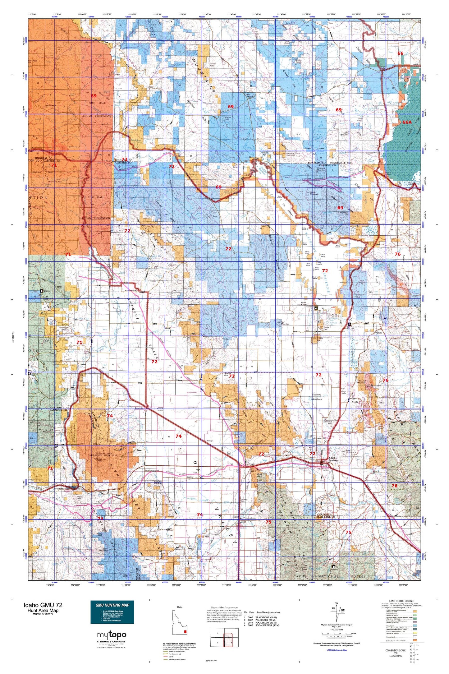
Idaho GMU 72 Map
Couldn't load pickup availability
Hunting unit map of Idaho Game Management Unit 72 with topographic lines and unit boundaries. This topo map features UTM / MGRS and Latitude/Longitude grids, plus public land ownership. It comes folded on waterproof paper. Be fully prepared for your hunt with a MyTopo GMU map!.
This map contains the following named places: 83217,83246,83276,Alexander,Alexander Dam,Alexander Reservoir,Allen and Cherry Ditch,Association Corral,Austin Ranch,Badger Knoll,Bailey Creek,Bakers Canyon,Bancroft,Bancroft Division,Bay Island,Bear Creek,Beaver Creek,Beker Tailings Number Three Dam,Bench A Canal,Bench B Canal,Big Jimmy Creek,Big Spring Creek,Bilious Creek,Blackfoot Dam,Blackfoot Reservoir,Blackfoot River Park,Blackfoot River Park Access Area,Blaser Station,Brush Creek,Buck Island,Buckskin Mountain,Bull Creek,Burchett Lake,Burton Creek,Camp Peak,Caribou County,Central,Chain Island,Chester Hill,Chesterfield,Chesterfield Cow Camp,Chesterfield Range,Chesterfield Reservoir,Chicken Creek,Chicken Point,China Cap,China Cap Dam,China Hat,Cinder Island,City of Bancroft,City of Lava Hot Springs,City of Soda Springs,Clarks Cut,Clements Ranch,Collett Creek,Conda,Conda Mine,Conda Site Tailings Dam,Cormorant Island,Corral Creek,Corral Creek Ridge,Coyote Creek,Crane Island,Cranes Flat,Crater Mountain,Crooked Creek,Deadman Creek,Deer Creek,Dempsey,Dewey Sulphur Mine,Doulls Ranch,Downey Canal,Dunn Basin,East Fork Twentyfour Mile Creek,Eighteenmile Creek,Eightmile Creek,Faulkner Ranch,Fish Creek,Fish Creek Range,Fort Hall Division,Fourth of July Creek,G Portal,Garden Creek,Goose Lake,Grace Dam,Grave Creek,Grave Creek Campground,Grays Lake Dam,Grizzly Creek,Gronewell Lake,Gull Island,Hadley Canyon,Hansen Corral,Hatch,Henderson Canyon,Henry,Henry Stampede Park,Hole in the Rock,Hopkins Landing,Horse Camp,Horse Creek,Idaho Ranch,Idaho Sulphur Mine,Indian Creek,Jeff Cabin Creek,Kelly Park,Kelly Toponce Ditch,King Creek,Kinport,Largilliere Creek,Last Chance Canal,Last Chance Dam,Lava Hot Springs,Ledger Creek,Limerock Mountain,Little Blackfoot River,Little Crater,Little Flat Canyon,Little Spring Creek,Little Valley,Little Valley Dam,Little Valley Hills,Little Valley Reservoir,Long Island,Long Ridge,Lower Portneuf Access Area,Lund,Lundgren Canyon,Meadow Creek,Meadow Creek Mountain,Meadowville,Menassa Creek,Meteor Hole,Middle Creek,Mill Creek,Miner Creek,Mollies Nipple,Monroe Canyon,Morgan,Moses Canyon,Moses Creek,Mount Moh,Negro Creek,Nelson Creek,Nelson Game Enclosure,Nettle Island,Ninety Percent Range,North Canyon,North Cone,North Extension Canal,Northside Narrows Access Area,Pack Saddle Basin,Pack Saddle Creek,Paradise Creek,Paradise Hills,Paradise Valley,Pebble,Pebble Creek,Pebble Siding,Pelican Ridge,Perkins Ranch,Peterson Creek,Petticoat Peak,Pine Grove,Poison Creek,Poison Creek Boat Ramp,Poison Creek Island,Portneuf Dam,Portneuf Marsh Valley Irrigation Company Feeder Canal,Rabbit Mountain,Rass Creek,Rat Lake,Rawlins Creek,Red House Canyon,Red Mountain,Reed Creek,Reservoir Mountain,Rindlishbaker Canyon,Robbers Roost,Rock Creek,Rose,Sagehen Campground,Sawmill Creek,Sawmill Ridge,Sheep Creek,Sheep Island,Short Creek,Smith Canyon,Smith Creek,Soda Canal,Soda Creek,Soda Creek Dam,Soda Dam,Soda Point,Soda Springs,Soda Springs Division,Soda Springs Hills,Split Island,Spring Creek,Spring Island,Squaw Creek,Stampede Park,Steamboat Hill,Sunday Creek,Supon Creek,Talmage,Tanner Canal,Tenmile Creek,The Narrows,The Reservoir,Thompson Creek,Three Buttes,Threemile Knoll,Toponce and Chesterfield Land Co Ditch,Toponce Creek,Trail Creek,Trailton,Twentyfour Mile Creek,Twentyfour Mile Dam,Twentyfour Mile Reservoir,Upper Portneuf Access Area,Warbonnet Creek,West Branch Canal,West Creek,West Fork Crooked Creek,West Steadman Ranch,Wham Creek,Willow Island,Wilson Creek,Wilson Ridge,Winchell Creek,Windy Ridge,Wood Creek,Woodall Mountain,Woodall Ranch