MyTopo
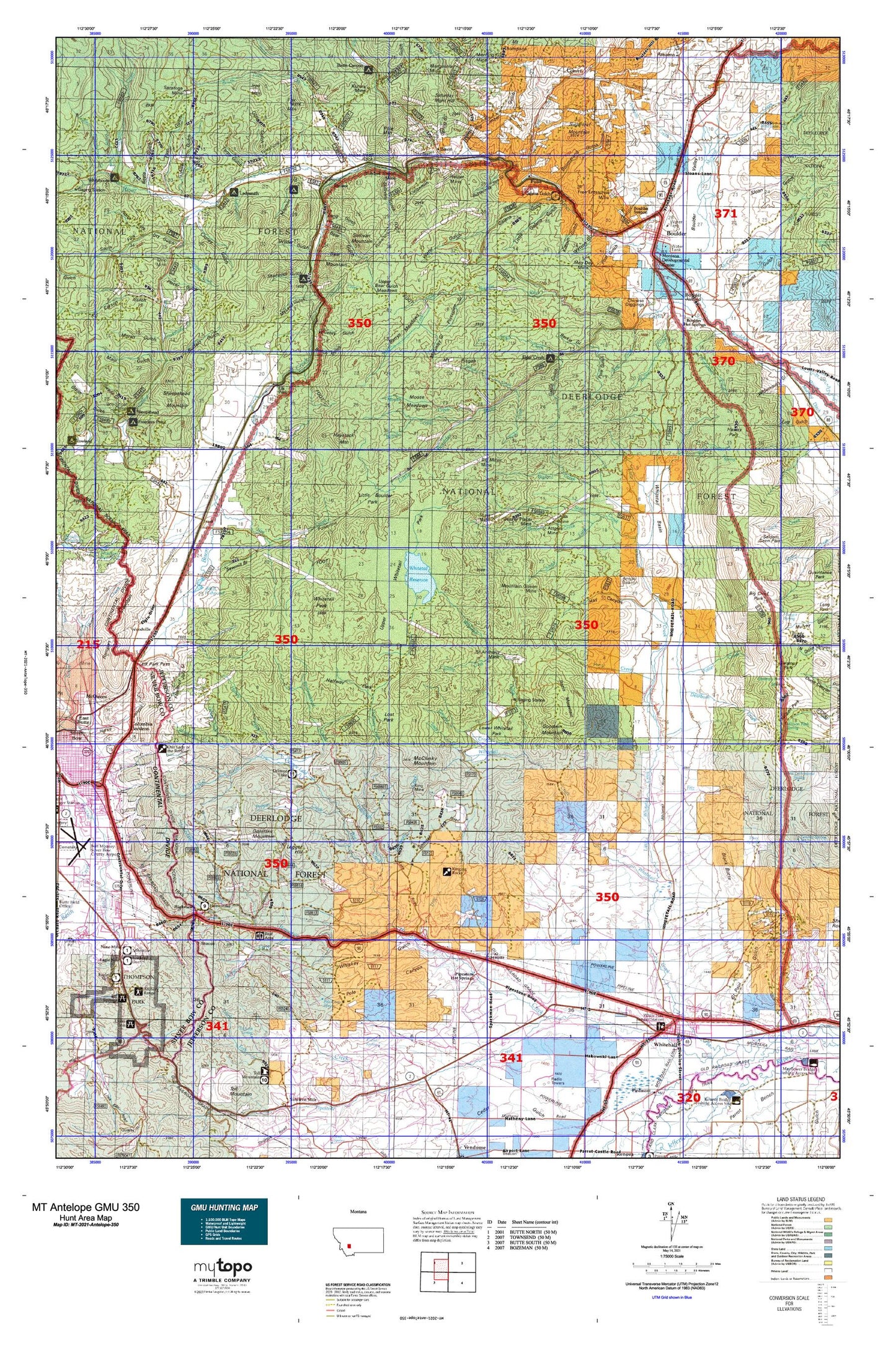
Montana Antelope GMU 350 Map
Couldn't load pickup availability
Hunting unit map of Montana Game Management Unit Antelope-350 with topographic lines and unit boundaries. This topo map features UTM / MGRS and Latitude/Longitude grids, plus public land ownership. It comes folded on waterproof paper. Be fully prepared for your hunt with a MyTopo GMU map!.
This map contains the following named places: Ajax Mine,Alice,Alport Mine,Amazon Creek,Attowa Mine,Aurora Mine,B and B Fishpond,Bald Mountain,Basin,Basin Creek,Battle Creek,Bear Mountain,Beaver Creek,Beaver Placer Mine,Beef Straight,Beefstraight Creek,Bernice,Berrys Meadows,Big Foot,Big Major Mine,Big Pipestone Viaduct,Bigfoot Creek,Bishop Creek,Bison Creek,Bison Creek Campground,Black Butte,Black Sheep Mountain,Blackstone,Blomberg,Blue Bell Health Mine,Bonan Hill,Boomerang,Boulder,Boulder Division,Boulder Hot Springs,Boulder River Bridge Historical Marker,Boulder River Schooland Hospital,Boulder Work Center,Brookes,Buffalo Creek,Bull Mountain Game Range,Bull Mountain State Wildlife Management Area,Caldwell Ranch,Calvin,Camp Caroline,Capital Hill,Cataract,Cataract Creek,Chinese Diggins,City of Boulder,Columbia Gardens Water Supply,Comet Tailings,Correa Ranch,Crowley Mine,Dearborn Creek,Deer Creek,Delmoe Campground,Delmoe Ditch,Delmoe Lake,Dry Creek,Dry Mountain,East Fork Red Rock Creek,Easter Lily Mine,Elder Creek,Elder Creek Picnic Area,Elk Park,Elk Park Campground,Elk Park Fire Hall,Eureka Mine,Farnham Creek,Finn Cabins,Fitz Creek,Fletcher Mountain,Forcella Ranch,Fox Mountain,Free Enterprise Health Mine and Campground,Free Enterprise Mine,Frog Pond,Fuller,Gillespie Creek,Gillespie Ranch,Goldflint Mountain,Goodwin Mountain,Grouse Creek,Halfway Creek,Haney Creek,Hartman Creek,Haystack Mountain,Headquarters Creek,Helper Mine,High Ore Creek,High Ore Spur,Highview,Homesite Creek,Homestake,Homestake Creek,Homestake Lake,Homestake Recreation Area,Homestake Rest Area,Hope Mine Spur,Hot Springs,Hyndman,Ice Pond,International Creek,Iron Mountain,Jasper,Jefferson County,Jerry Smith Creek,Keogh Ranch,Keogh Reservoir,King Mine,Kit Carson Gulch Creek,Konda Ranch,Kyle,La Casa Trailer Park,Ladysmith Campground,Ladysmith Creek,Ladysmith Picnic Ground,Larson Ranch,Legget Hill,Lewis,Little Boulder,Little Boulder River,Little Pipestone Creek,Little Whitetail Creek,Lowland Creek,Lumber Spur,Mantle Mine,Marie,Marsh Mine,May Day Mine,McAllister Ranch,McCarty Creek,McClusky Mountain,Menzemer,Mikels,Mining Country Historical Marker,Montana State Highway Department Sandhouse,Moose Creek,Mormon Campground,Mormon Gulch Campground,Mount Pisgah,Mountain Queen Mine,Mountain Valley Trailer Court,Muskrat Creek,Nez Perce Creek,North Fork Little Boulder River,North Fork Red Rock Creek,Omsons Spur,O'Neil Creek,O'Neill Campground,Our Lady of the Rockies,Pappas Creek,Pappas Place,Paul Place,Paul-McArthur Ditch Number One,Pipestone,Pipestone Campground,Pipestone Ditch,Pipestone Hot Springs,Pipestone Rock,Pole Mountain,Pony Creek,Potter Creek,Pulpit Rock,Ratio Mountain,Rawhide Creek,RCRV Park,Red Rock,Red Rock Creek,Rice Motel and Trailer Court,Rieder,Ringing Rocks,Rocky Canyon Creek,Ruby Creek,Ruby Mine,Sage Creek,Saint Anthony Mine,Salsbury,Saratoga Mine,Sauls Claim,Sawmill Creek,SE SE Section 32 Mine,Shamrock Campground,Shedhorn Creek,Sheep Creek,Sheepshead Mountain,Shiels and Ironsides Mine,Silver Queen Mine,Simonsen Ranch,Sloan Ranch,Smelter,South Fork Red Rock Creek,South Fork State Creek,Spencer Creek,Spire Rock,Spire Rock Viaduct,Spring Creek,Springtime Mine,State Creek,State Highway Department Sandhouse,State Mine,Stockmens Association Cabin,Sugarloaf Mountain,Suicide Cabin,Sullivan Mountain,Sunnyside Ranger Station,Sunset Trailer Court,Taylor Reservoir,Tesky Creek,Tippet Place,Tomahawk Ranch,Town of Whitehall,Trask,Tunnel Number 5,Upper Whitetail Park Trail,Valley,Welch,Welch Quarry,West Creek,White Tail Deer,Whitehall,Whitehall Creek RV Park,Whitehall Division,Whitehall Ranch,Whitetail Basin,Whitetail Deer Creek,Whitetail Ditch,Whitetail Peak,Whitetail Reservoir,Wilder,Wilson Creek,Wissikihon Creek,Wood Creek,Woodville