MyTopo
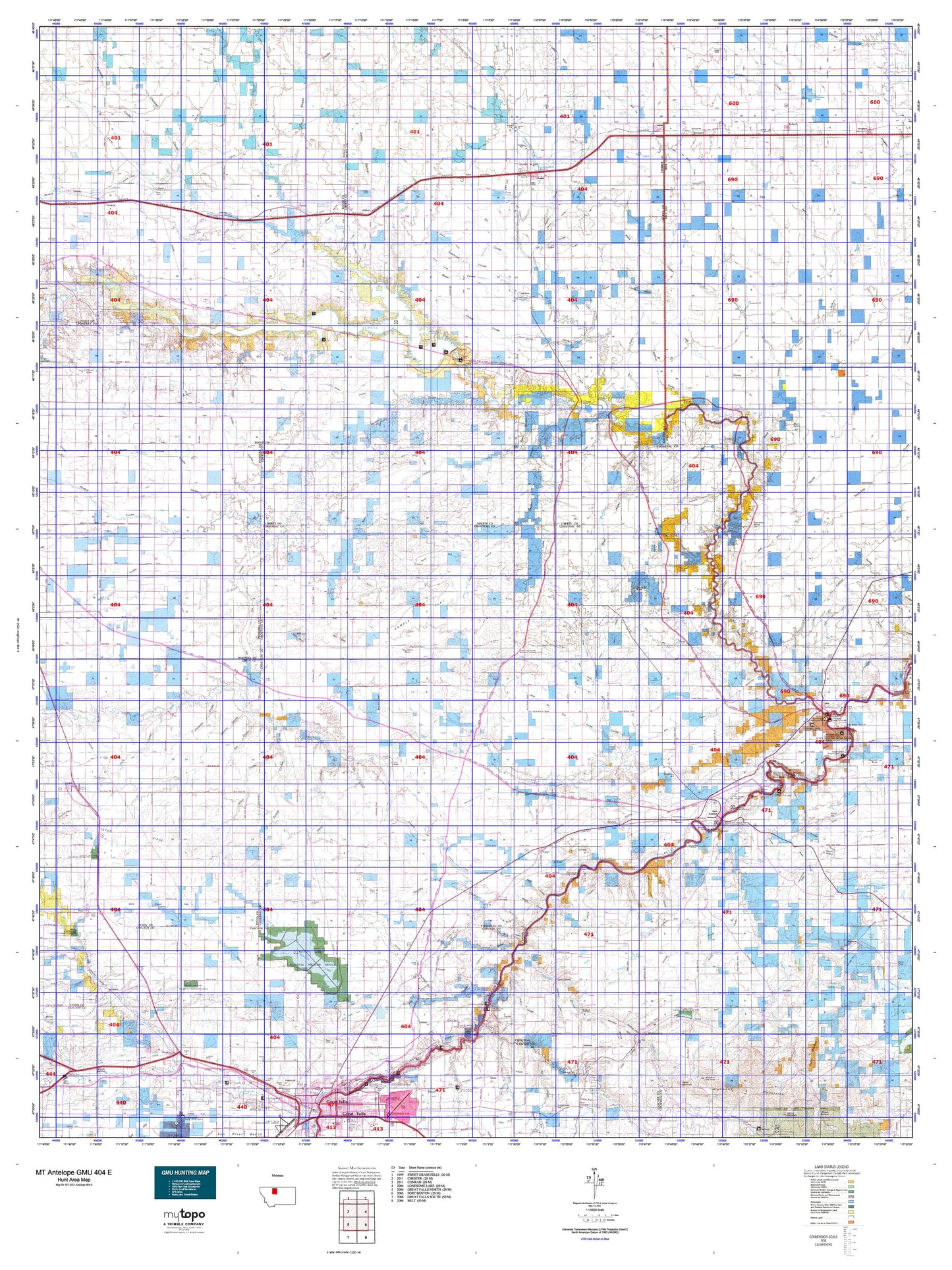
Montana Antelope GMU 404 E Map
Couldn't load pickup availability
Hunting unit map of Montana Game Management Unit Antelope-404-E with topographic lines and unit boundaries. This topo map features UTM / MGRS and Latitude/Longitude grids, plus public land ownership. It comes folded on waterproof paper. Be fully prepared for your hunt with a MyTopo GMU map!.
This map contains the following named places: 59404,59416,59420,59440,59442,59456,59460,59461,59522,59530,59540,Antelope Lake,Arnouxs Ranch,Ashmoor,Athlone,Austin,Aznoe,Baker Bar,Bar Z F Ranch,Belt Creek,Bennett Ranch,Benton Lake,Benton Lake National Wildlife Refuge,Benton RV Park,Bessette Ranch,Big Coulee,Big Falls,Big Sag,Big Sag Creek,Big Sag Lake,Birkeland Reservoir,Black Butte,Black Coulee Hall,Black Horse Lake,Booth Dam,Bootlegger Trail,Bourne and Hamilton Reservoir,Box Elder Creek,Bramlette Dam,Brinkman,Browns Reservoir,Brule Bar,Buelow,Carl O'Hara Ranch,Carter,Carter City Park,Carter Ferry Fishing Access Site,Carter Mountain,Chester,Chester City Park,Chester Division,Chester Rest Area,Childrers Reservoir,Chinaman Hill,Chip Creek,Chouteau County Fairgrounds,City of Fort Benton,Colony Bay,Columbia Grain Incorporated Elevator,Cottonwood Bottom,Cottonwood Creek,D and S RV Park,Denson Ranch,Devon,Devon Gas Field,Diamond Valley,Dick Golie Fish Pond,Dick Golie Wildlife Dam,Discovery Butte,Dry Fork,Dunbar Hill,Eagle Creek,East Community Center,East Knee,Egly Country Club,Eight Mile Springs,Eightmile Springs,Erin,Evans Bend,Farmers Elevator,Flick Lake,Floweree,Floweree Lake,Fort Benton,Fort Benton City Park Rest Area,Fort Benton Division,Fort Benton Historical Marker,Fort Brule,Fort Campbell,Fort Cotton,Fort LaBarge,Fort Lewis,Fowler Reservoir,Freiling Ranch,Gagnon Reservoir,Galata,Galata Motel and RV Campground,General Mills Incorporated Elevator,Genou,George,Gillespie Reservoir,Goose Bill Butte,Great Falls North Division,Great Northern Reservoir,Greeley Elevator,Hanford Dam,Harvest States Cooperative Elevator,Harvest States Cooperatives Elevator,Hay Coulee,Hay Stack Coulee,Haystack Butte,Hess,Highwood,Highwood Creek,Hilltop Silo,Hingham Lake,Hollandsworth Reservoir,Hop Creek,Horse Creek,Huntley,Inverness,Island Area Campground,Iverness,Jensen Elevator,Joplin,Keaster Creek,Kershaw,Lacey Creek,Lake Creek,Lake Elwell,Lakey Ranch,Lander Crossing,Lees Lake,Lewis and Clark State Memorial,Liberty County,Liscum,Loma,Loma Bridge Fishing Access Site,Lothair,Lucille,Marias,Marias River Historical Marker,Mc Carters Lake,McCarter Lake,McIntyre Reservoir,Morony Dam,Morony Reservoir,Neuman Dam,Nine Mile,North Bootlegger Campground,North Bootlegger Picnic Area,North Gap Creek,O'Hara Brothers Ranch,Patterson,Peavey Company Grain Elevator,Pleasant Valley,Portage,Portage Pit,Potts Reservoir,Prescott Reservoir,Pugsley Reservoir,Rehal Flat,Rice Reservoir,Riverview Colony,Robertson Dam,Rocky Mountain Elevator,Romain Reservoir,Roosevelt Island,Rowe Bench,Rudyard,Rudyard Division,Rudyard Gun Club,Russell,Ryan Dam,Sand Lake,Sanford Park,Sanford Park Campground,Selma,Shay Reservoir,Sheffels,Shep Memorial,Shepherd Butte,Shepherd Crossing,Shonkin,Shonkin Bar,Shonkin Creek,Shonkin Lake,Shotgun Slough,Signal Point Golf Club,Sollid,South Bootlegger Campground,South Bootlegger Picnic Area,Springs,State Elevator,Stevenson Ranch,Stewart Ranch,Streit Ranch,Sun River Junction,Sunnybrook Colony,Sweet Grass Hills Historical Marker,Telstad,Telstad Pumping Station,Teton River,Teton Station,The School House,Tiber,Tiber Dam,Tiber Dam Camp,Tiber Marina Campground,Town of Chester,Trail Creek,Tunis,Twenty-Eight Mile Spring,Twin Hills Colony,Uphill Creek,Utopia Gas and Oil Field,Valleux,Vaughn,VFW Campground,Volta,Walden Reservoir,Waltham,Watson,West Fork Willow Creek,West Knee,Westermark Grain Corporation Elevator,White Elephant Reservoir,Whoop-Up Trail Monument,Willow Creek,Willow Creek Campground,Witt Ranch,Woods Crossing,World War I Memorial,Yemen,Zelenka Dam