MyTopo
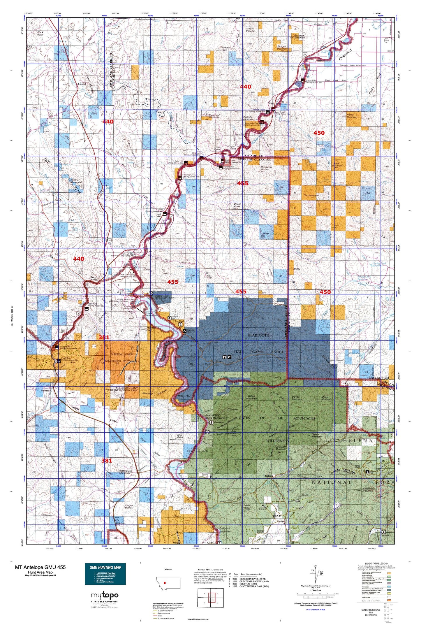
Montana Antelope GMU 455 Map
Couldn't load pickup availability
Hunting unit map of Montana Game Management Unit Antelope-455 with topographic lines and unit boundaries. This topo map features UTM / MGRS and Latitude/Longitude grids, plus public land ownership. It comes folded on waterproof paper. Be fully prepared for your hunt with a MyTopo GMU map!.
This map contains the following named places: 15N04W03BB__01 Well,17N01W08D___01 Well,17N01W08D___02 Spring,17N01W19D___01 Well,17N01W26B___01 Spring,17N01W27B___01 Well,17N01W29C___01 Well,17N02W25C___01 Well,17N02W35D___01 Well,Acres Gulch,Adel Mountain,American Bar,American Bar Gulch,Andy Creek,Antelope Mountain,Baldy,Barrett Field,Bear Gulch Creek,Bear Prairie,Beartooth Creek,Beartooth Game Management Area,Beartooth Mountain,Beartooth Ranch,Billings Slough,Black Mountain,Bray Gulch,Brewer Hill,Bridge Creek,Browns Flat,Brunots Rapids,Burke Creek,Caldwell Homestead,Camp Gulch,Candle Gulch,Candle Mountain,Cap Mountain,Carterville / Wolf Creek Cemetery,Checkerboard Gulch,Checkerboard Ranger Station,Chisholm Mountain,Clark Homestead,Coburn Mountain,Cottontail Gulch,Cottonwood Creek,Coulter Campground,Coulter Canyon,Cox Creek,Craig,Craig Cemetery,Craig Census Designated Place,Craig Fishing Access Site,Curran-Barrett Number 1 Dam,Curran-Barrett Number 2 Dam,Deadman Creek,Dearborn,Dearborn Fishing Access Site,Dearborn Ranch,Dearborn Rest Area,Dearborn River,Deerborn Reservoir Dam,DeLacey Point,Dennison,Departure Point Campground,Diamond Gulch,Dog Creek,Doig Mine,Eagle Island Fishing Access Site,Eagle Rock,Elephant Mountain,Elkhorn Creek,Falls Gulch,Fields Gulch,Finigan Creek,Finigan Mountain,Flat Creek,Flennikens Rapids,Frazier Creek,Gary,Gates of the Mountains and the Bear Tooth Historical Marker,Gates of the Mountains Boat Club,Gates of the Mountains Game Preserve,Gates of the Mountains Wilderness,Gates of the Rocky Mountains,Gilman Gulch,Gilmore Siding,Gleason,Grant Gulch,Hardy,Hardy Bridge,Hardy Bridge Fishing Access Site,Hardy Census Designated Place,Hardy Creek,Harris Creek,Harris Mountain,Hilger Ranch,Hilger Valley,Hilger Well,Hilgersville,Hogback Mountain,Holter Dam,Holter Lake,Holter Lake Campground,Holter Lake State Recreation Area,Hump Cabin,Hunters Gulch,Indian Trail Lodge,Jackson Peak,Juniper Campground,Keepout Gulch,Kennedy Spring,KTVH-TV (Helena),Left Fork Big Log Gulch,Lemline Gulch,Lesofski Homestead,Lincoln,Little Creek,Little Prickly Pear Creek,Little Stickney Creek,Log Gulch,Log Gulch Campground,Log Gulch Recreation Area,Lone Pine Rapids,Long Gulch,Manila,Mann Gulch,Mann Gulch Fire Smokejumper Meemorials,McKinzter Homestead,McLeod Gulch,Meriwether Canyon,Meriwether Guard Station,Meriwether Picnic Area,Mid Canon,Mid Canon Fishing Access Site,Ming Bar,Ming Bar Landing Strip,Ming Creek,Missouri Inn Campground,Missouri River Canyon Historical Marker,Missouri River Ranch Airport,Montana River Outfitters Campground,Moore Creek,Moore Graves,Moore Hill,Moors Creek,Moors Mountain,Mount Rowe,Mountain Palace Fishing Access Site,Muddy Spring,Nelson,Nohrgang Ranch,North Fork Sheep Creek,North Fork Stickney Creek,Novak Creek,Old Ives Place,Old Weiss and French Place,Oxbow Bend,Oxbow Landing Strip,Oxbow Ranch,Paul Creek,Payne Camp,Pelican Point Fishing Access Site,Picnic Canyon,Pike Creek,Pine Island,Pine Island Rapids,Pole Creek,Prewett Creek,Prewett Creek Fishing Access Site,Rattlesnake Gulch,Rattlesnake Mountain,Refrigerator Canyon,Retloh Junction,River Canyon RV Park,Rock Creek,Rock Creek Ranch,Rose Gulch,Sacajawea Mountain,Saint Peters Mission Historical Marker,Sawmill Creek,Sawmill Peak,Sawtooth Mountain,SE NE Section 10 Mine,Sentinel Ranch,Sentinel Rock,Sheep Creek,Sheep Creek Mine,Sheep Gulch,Sheep Mountain,Shellrock Ridge,Slip Gulch,South Fork Sheep Creek,South Fork Stickney Creek,Sperry Ranch,Spite Hill Fishing Access Site,Spring Gulch,Stickney Creek,Stickney Creek Fishing Access Site,Stony Point,Stump Gulch,Sugarloaf Mountain,Sullivan Creek,Sulphur Gulch,Sunny Crest Ranch,SW NW Section 14 Mine,Table Rock Fishing Access Site,Tender Gulch,The Devils Kitchen,The Painted Rock,The Sawteeth,The Twin Sisters,Timber Hill,Timberman Homestead,Tintinger Siding,Tintinger Slough,Towhead Gulch,Trout Creek,Tunnel Number 1,Tunnel Number 3,Turnout Spring,Twin Bridge Coulee,Tyrell Camp,Upper Holter Lake,Wegner Creek,West Sheep Creek,Whitetail Prairie,Wigand Park,Willow Creek,Willow Mountain,Wolf Creek,Wolf Creek Bridge Fishing Access Site,Wolf Creek Census Designated Place,Wolf Creek Division,Wolf Creek Gaging Station,Wolf Creek Quarry,Yank Creek