MyTopo
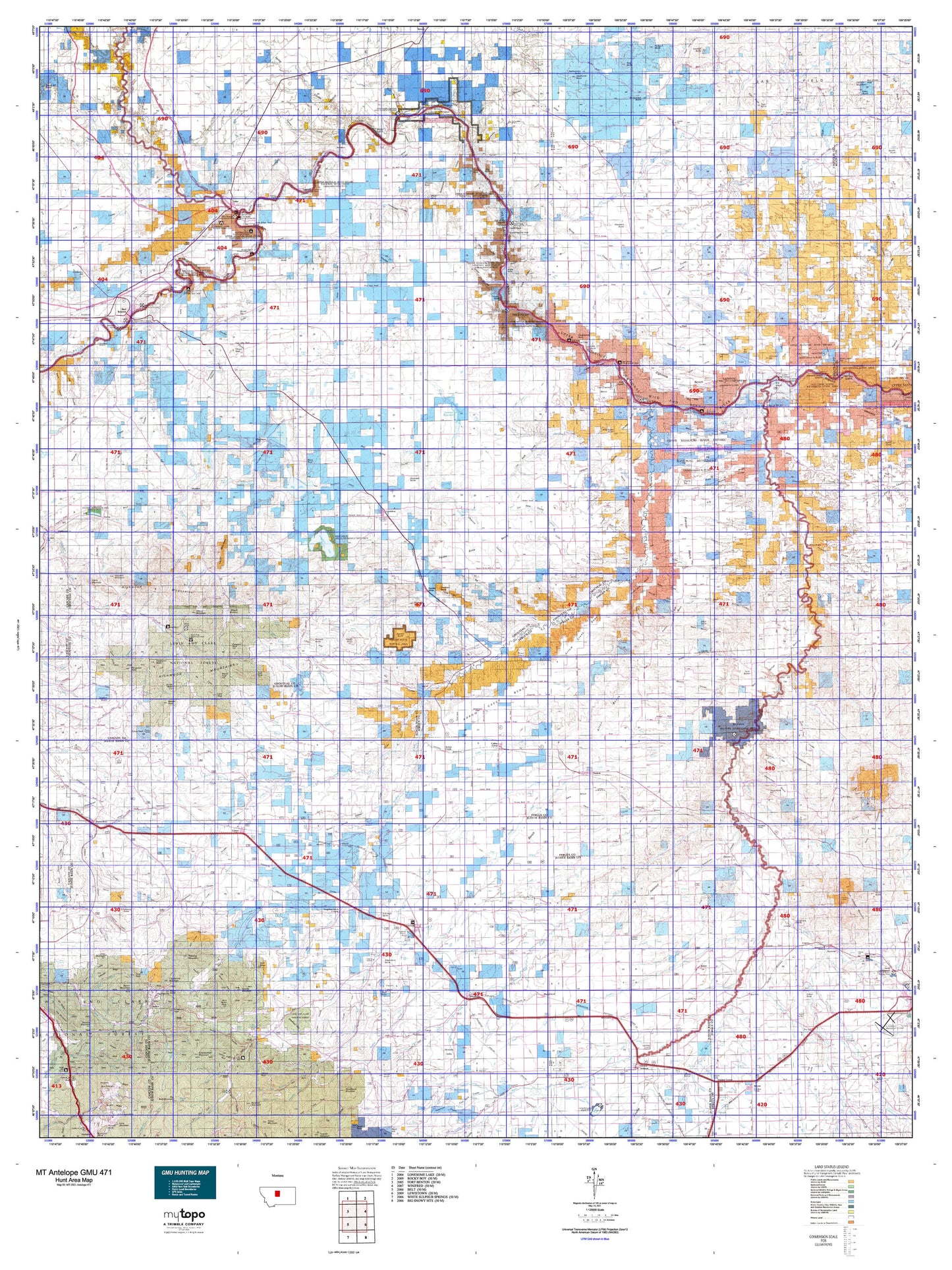
Montana Antelope GMU 471 Map
Couldn't load pickup availability
Hunting unit map of Montana Game Management Unit Antelope-471 with topographic lines and unit boundaries. This topo map features UTM / MGRS and Latitude/Longitude grids, plus public land ownership. It comes folded on waterproof paper. Be fully prepared for your hunt with a MyTopo GMU map!.
This map contains the following named places: Alkali Creek,Amherst,Anderson Peak,Antelope Butte,Archers Island,Arrow Creek,Arrow Peak,Baker Bar,Benchland,Big Lake,Big Sandy Division,Big Spring Creek,Birch Creek,Black Butte,Black Buttes,Black Rock,Blacktail Hills,Boggs Island,Box Elder Creek,Brule Bar,Buckskin Butte,Butcherknife Mountain,Cairo,Carl O'Hara Ranch,Carter Mountain,Central Montana Cooperative Elevator,Chappell,Chase Hill,Cherry Top,Chimney Rock,Chip Creek,Chouteau County,Chouteau County Waterfowl Production Area,Churchill Butte,Clagget Hill,Clear Lake,Clendenin Mountain,Clydes Creek,Coal Banks Landing,Coalbanks Campground,Coalbanks Recreation Area,Coffee Creek,Colony Bay,Connely Creek,Cotton Trailer Court,Council Island,Coyote Creek,Crow Coulee Bar,Dammel Reservoir,Danvers,Dark Butte,Deerfield Colony,Denton,Denton City Park,Denton Division,Dog Creek,Dover,Dry Fork,Dry Wolf Creek,Dry Wolf Ranger Station,Duck Creek,Eagle Buttes,Eagle Creek,Eagle Creek Fishing Access Site,Eagleton,East Fork Birch Creek,East Ophir,East Peak,Edith Nelson Trailer Court,Eskay,Evans Bend,Evers Ranch,Everson,Everson Community Hall,Farmers Cooperative Elevator,Fort Brule,Fort Chardon,Fort Chardon Historical Marker,Fort Piegan,Fortress Rock,Fourmile Hill,Freiling Ranch,Galena,Gallatin Valley Milling Company Elevator,General Mills Incoporated Elevator,General Mills Incorporated Elevator,Geraldine,Geraldine Division,Geyser,Geyser Division,Geyser Elevator,Geyser Rest Area,Granite Mountain,Hall Trailer Court,Harwood Lake,Harwood Stage Station,Hawarden Hall,Haystack Butte,Highwood Baldy,Highwood Cow Camp,Highwood Guard Station,Hoosac,Hopp,Hughesville,Iliad,Indian Buttes,Indian Creek,Indian Graves Butte,J and M Trailer Court,Johnson Hill,Judith,Judith Basin County,Judith Landing Campground,Judith Landing Historical Marker,Judith Landing Recreation Area,Judith River Historical Marker,Kelley Creek,King Ranch Colony,Kingsbury Lake,Kingston,Kolin,Lava Peak,Leadville,Lehigh,Lepley,Lepleys Creek,Libby Hills,Lidstone Hill,Lions Club Park,Lippard,Liscum,Little Battle Creek,Little Birch Creek,Little Eagle Creek,Loma,Loma Bridge Fishing Access Site,Lone Tree Creek,Lonetree,Longs,Lost Lake,Marias,Marias River Historical Marker,McNamara Butte,Mennonite,Merino,Middle Peak,Mining Plays Second Fiddle Historical Marker,Missouri Wild and Scenic River,Mixes Baldy,Moccasin,Montague,Montana Crossroads Historical Marker,Mount Hancock,Mount Kennon,North Ophir,North Peak,O'Hara Brothers Ranch,Old Fort Clagget,Ophir,Pablo Island,Palisade Butte,Panton Coulee Reservoir,Patterson,Peterson Mountain,PN Island,PN Ranch,Pownal,Prospect Peak,Rattlesnake Butte,Reed Hill,Rocky Lake,Ross Fork,Round Butte,Round Top,Ryan Butte,Samples Crossing,Sand Lake,Sand Rock Hill,Sawmill Butte,Scholtztown,Seifort Reservoir,Seventynine Hill,Seventynine Ranch,Seventytwo Hills,Shaws Peak,Shonkin,Shonkin Bar,Shonkin Cow Camp,Shonkin Lake,Skull Butte,South Peak,Spion Kop,Spring Creek Colony,Spring Creek Junction,Square Butte,Stanford,Stanford City Park,Stanford Division,State of Montana,Steamboat Butte,Steamboat Rock,Steamerville,Stevenson Ranch,Stranahan,Streit Ranch,Studhorse Butte,Surprise Creek,Surprise Creek Colony,Taylor Mountain,Taylor Peak,Teton Station,Thain Creek Campground,The Badlands,The Peak,The Point,The Rock,Three Islands,Tiger Butte,Tobin,Town of Denton,Town of Geraldine,Town of Stanford,Tox Hill,Twin Buttes,Virgelle,Ware,Warrick,Western Lumber and Grain Company Elevator,White Lake,White Rocks,Wild Horse Butte,Windham,Windy Mountain,Wolf Butte,Wolf Island