MyTopo
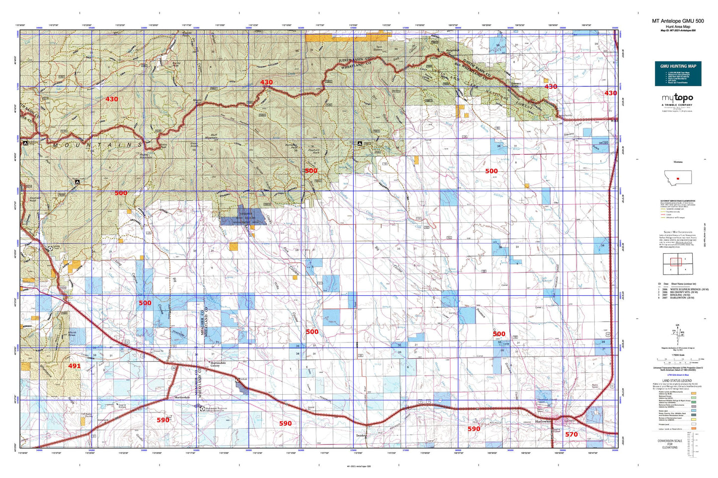
Montana Antelope GMU 500 Map
Couldn't load pickup availability
Hunting unit map of Montana Game Management Unit Antelope-500 with topographic lines and unit boundaries. This topo map features UTM / MGRS and Latitude/Longitude grids, plus public land ownership. It comes folded on waterproof paper. Be fully prepared for your hunt with a MyTopo GMU map!.
This map contains the following named places: 08N11E11____01 Well,08N11E14____01 Well,08N11E14D___01 Well,08N12E04____01 Well,08N12E09BDD_01 Well,08N13E01____01 Well,08N14E02DDBA01 Well,08N14E10B___01 Well,08N14E11C___01 Well,08N14E13____01 Well,08N14E19B___01 Well,08N14E23A___01 Well,08N15E18C___01 Well,09N11E34C___01 Well,09N12E28____01 Well,09N13E09____01 Well,09N13E11CADC01 Well,09N14E12ADB_01 Well,09N14E30A___01 Well,09N15E07C___01 Well,10N11E28B___01 Well,10N11E28C___01 Well,10N12E30CBBA01 Well,10N13E12ABBA01 Well,10N13E21____01 Well,10N13E29C___01 Well,10N14E20____01 Well,10N14E20C___01 Well,10N14E28B___01 Well,10N14E28C___01 Well,10N14E32B___01 Well,10N15E06B___01 Well,11N14E34DCA_01 Well,11N15E31C___01 Well,59036,59053,Alkali Creek,Barnhart Coulee,Bartleson Peak,Basin Creek,Basin Creek Campground,Baxter Gulch,BCE Number 3959 Mine,Big Coulee,Bluff Mountain,Boecher Spring,Cameron Creek,Capser Ranch,Charles M Bair Family Museum,Clara Burton Mine,Clarks Desert Spring,Clarks Fork Morrisy Coulee,Clendennin School,Cooper Creek,Cottonwood Creek,Crazy Mountains Historical Marker,Cross Creek,Daisy Dean Creek,Daisy Guard Station,Daisy Narrows,Daisy Notch,Daisy Peak,Deadhorse Creek,Devee Post Office,Dry Fork Daisy Dean Creek,Dry Gulch,Duncan Colony School,Duncan Ranch Colony,Duncan Ranch Colony Census Designated Place,East Fork Haymaker Creek,East Fork Hopley Creek,East Fork Spring Creek,East Martinsdale Dam,Elephant Rock,Fawn Creek,Fifty Dollar Bill Dam,Findon,Findon Post Office,Findon School,Forks Spring,Fort Howie,Gauglersville,Gauglerville Cemetery,Gauglerville School,Gillis Creek,Godfrey,Green Canyon,Harlowton Division,Haymaker Dam,Haymaker Narrows,Haymaker Park,Haymaker Post Office,Haymaker Ranch,Haymaker State Wildlife Management Area,Hidden Lake,Holliday Landing Strip,Hopley Spring,Hundred Dollar Bill Dam,Iron Springs,Iron Springs Coulee,Jellison Place,Jellison Reservoir,Johnson Park,Jumbo Mine,Kents Gulch,Lode Ranch,Long Canyon,Lucky Boy Mine,Manger Millsite,Martinsdale,Martinsdale Census Designated Place,Martinsdale Colony,Martinsdale Colony Census Designated Place,Martinsdale Colony School,Martinsdale Fire Station,Martinsdale Post Office,Martinsdale Reservoir,Martinsdale Reservoir Fishing Access Site,Martinsdale School,Mead Creek,Mexican John Creek,Middle Fork Hopley Creek,Middle Fork Reservoir,Mill Ditch,Morris Creek,Morrisy Coulee,Morrisy Coulee Narrows,Morrisy Coulee Spring,Mount High,Mount Howe,Mud Creek,Muddy Mountain,Muir Spring,Nelson Irrigation Dam,Nelson Reservoir,Nevada Creek,Nevada Narrows,New Deal Mine,North Fork Musselshell River,North Martinsdale Dam,NW NE Section 15 Mine,Olaf Community Center,Olaf School,Olof Post Office,Pasture Gulch,Picnic Canyon,Pierce Coulee,Quaking Aspen Coulee,Russian Creek,Russian Flat,Russian Flat Airport,Sawmill Canyon,Selkirk,Selkirk Fishing Access Site,Selkirk School,Sixshooter Spring,Smith Creek,South Fork Musselshell River,Spring Creek,Stevens Butte,Stone Ranch,SW NW Section 15 Mine,Third Stooges Dam,Townsend Gulch,Trombone Creek,Trombone Spring,Twodot Canal,West Fork Hopley Creek,West Fork Mud Creek,West Fork Nevada Creek,West Hopley Spring,Wheat Crop Dam,Whetstone Creek,Willis Coulee,Willow Creek,Willow Park,Woods Gulch