MyTopo
Montana Antelope GMU 501 Map
Couldn't load pickup availability
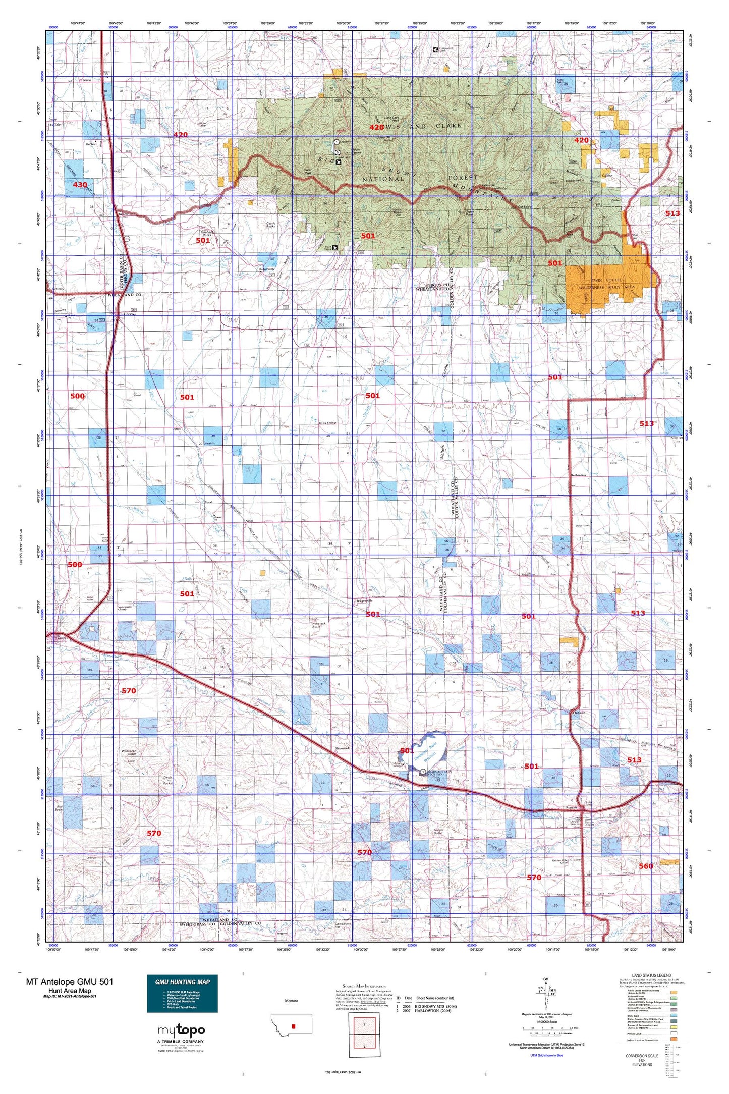
Hunting unit map of Montana Game Management Unit Antelope-501 with topographic lines and unit boundaries. This topo map features UTM / MGRS and Latitude/Longitude grids, plus public land ownership. It comes folded on waterproof paper. Be fully prepared for your hunt with a MyTopo GMU map!.
This map contains the following named places: 06N16E03____01 Well,06N16E05____01 Well,06N17E02CBA_01 Well,06N18E15BBA_01 Well,06N19E01BCCC01 Well,06N20E05DA__01 Well,06N20E06ADA_01 Well,07N16E27CABC01 Well,07N16E35____01 Well,07N17E24DD__01 Well,07N17E25____01 Well,07N18E08DDC_01 Well,07N18E19____01 Well,08N17E29BBB_01 Well,08N18E08____01 Well,08N18E16____01 Well,08N19E25CCAC01 Well,09N16E05C___01 Well,09N16E13C___01 Well,09N16E24A___01 Well,09N17E13B___01 Well,09N17E21C___01 Well,10N16E06ADD_01 Well,10N17E24B___01 Well,10N17E25C___01 Well,10N17E36B___01 Well,10N18E09____01 Well,10N19E34A___01 Well,11N16E02DA__01 Well,11N16E02DA__02 Well,11N16E03AA__01 Well,11N16E03CA__01 Well,11N16E03CA__02 Well,11N16E04BD__01 Well,11N16E05CB__01 Well,11N16E05CB__02 Well,11N16E05CB__03 Well,11N16E06AA__01 Well,11N16E06AA__02 Well,11N16E14AC__01 Well,11N16E15CB__01 Well,11N16E15CB__02 Well,11N16E20CD__01 Well,11N16E21AC__01 Well,11N16E21AC__02 Well,11N16E25C___01 Well,11N16E33A___01 Well,11N18E33____01 Well,12N16E16DC__01 Well,12N16E16DC__02 Well,12N16E17BB__01 Well,12N16E17BB__02 Well,12N16E18AA__01 Well,12N16E18AA__02 Well,12N16E18AA__03 Well,12N16E18AA__04 Well,12N16E20BB__01 Well,12N16E22BC__01 Well,12N16E22CB__01 Well,12N16E28AC__01 Well,12N16E28AC__02 Well,12N16E29AC__01 Well,12N16E30AB__01 Well,12N16E31AC__01 Well,12N16E31DC__01 Well,12N16E32CC__01 Well,12N16E32CC__02 Well,12N16E32DB__01 Well,12N16E32DB__02 Well,12N16E36AD__01 Well,13N16E26AD__01 Well,13N16E26DC__01 Well,13N16E26DC__02 Well,13N16E30DC__01 Well,13N16E30DCAA01 Well,13N16E32BD__01 Well,13N16E32BD__02 Well,13N16E32BD__03 Well,13N16E32BDDD01 Well,13N16E35BC__01 Well,13N16E35BC__02 Well,59074,59078,59453,Alkali Creek,Allen Ranch,American Fork,Ashley Coulee,Bad Canyon,Barber,Barber Bridge,Barber Cemetery,Barber School,Bercail,Bercail School,Berg Dam,Big Snowy Mountains,Black Ridge,Blake Creek,Blake Creek Forest Station,Bowmans Bench,Brooks Coulee,Browns Gulch,C Volf Dam,Castle Rocks,Cinnamon Number 10 Dam,Cinnamon Number 2 Dam,Cinnamon Number 6 Dam,City of Judith Gap,Clowry,Cottonwood Coulee,Crystal Cascades,Crystal Lake,Crystal Lake Boat Launching,Crystal Lake Campground,Crystal Lake Guard Station,Crystal Lake National Recreation Trail,Crystal Lake Picnic Area,Deadmans Basin Campground,Deadmans Basin Dam,Deadmans Basin Dike,Deadmans Basin Fishing Access Site,Deadmans Basin Outlet Canal,Deadmans Basin Reservoir,Deadmans Basin Supply Canal,Devils Pocket,Dodgetown,Dry Ashley Gulch,Dry Canyon,Dry Coulee,East Fork Blake Creek,East Fork Cottonwood Creek,East Fork Green Pole Canyon,East Fork Roberts Creek,East Fork Rock Creek,East Fork Timber Creek,Elephant Rocks,Elk Creek,Ernie Hudson Dam,Ethels Coulee,Farmers Elevator,Fish Creek,Franklin,Franklin School,Galloway Creek,Garneill,Garneill Cemetery,Garneill Elevator,Grand View Recreation Site,Greathouse Peak,Green Ashley Gulch,Green Canyon,Green Pole Canyon,Halbert Creek,Half Moon Canyon,Half Moon Creek,Half Moon Pass,Half Moon Pass School,Haystack Butte,Hedges Cemetery,Hedgesville,Huffman Gulch,Hyde Creek,Hyde Creek School,Indian Butte,Irene School,Judith Gap,Judith Gap-Shawmut Division,Jump Off Peak,Knife Blade Ridge,Lammers Airport,Lime Cave Peak,Little Careless Creek,Living Springs,Lost Peak,Manley School,Mills Coulee,Mount Harlow,Mountain View School,Mud Creek,Niel Creek,Nihill Siding,No Name Canyon,Oka Coulee,Old Baldy,Oxford,Pontiac,Porcupine Gulch,Ray Jerrers Number 1 Dam,Resurrection Cemetery,Roberta,Roberts Creek,Rocky Mountain Elevator,Rogers Spring,Rothiemay,Rothiemay Cemetery,Rothiemay School,Ryegate,Ryegate Airport,Ryegate Cemetery,Ryegate City Park,Ryegate Public Schools,Schaffs RV Court,Seepy Spring Coulee,Shawmut,Shawmut Census Designated Place,Snow Saucer Coulee,Spring Creek,Springwater Colony Census Designated Place,Stella Number 1 Dam,Stevens Gulch,Stovepipe Canyon,Swimming Woman Creek,Tepee Coulee,Tepee Point,Tie Camp Coulee,Timber Creek,Town of Ryegate,Wallum,Wallum School,Walters Coulee,West Bercail Creek,West Evers Saw Mill,West Fork Blake Creek,West Fork Cottonwood Creek,West Fork Timber Creek,West Galloway Creek,West Gulch,West Peak,Wild Horse Butte,Windy Point,Winnecook,Winnecook Siding,Wrzesinski Coulee,Yaple Bench