MyTopo
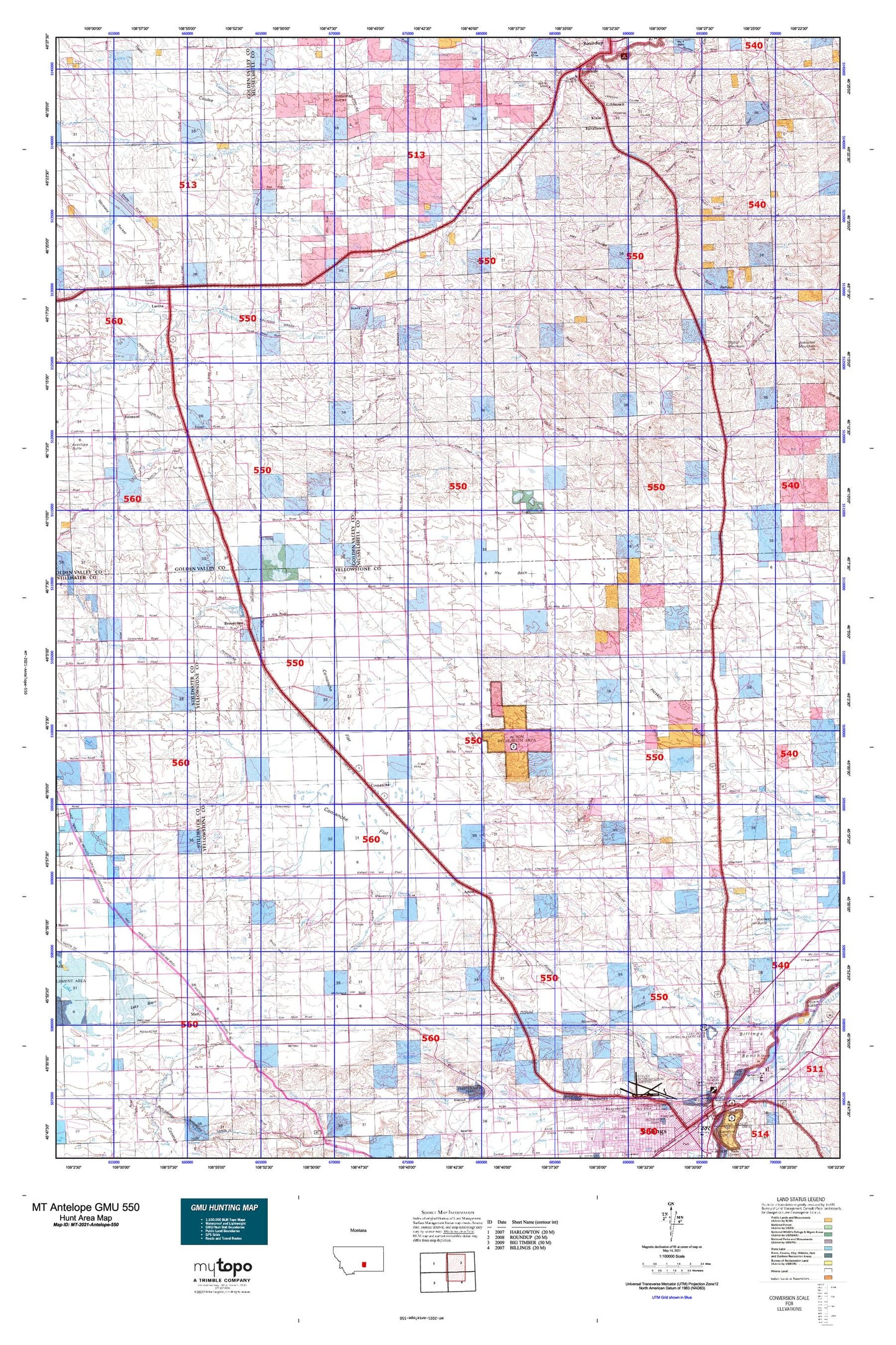
Montana Antelope GMU 550 Map
Couldn't load pickup availability
Hunting unit map of Montana Game Management Unit Antelope-550 with topographic lines and unit boundaries. This topo map features UTM / MGRS and Latitude/Longitude grids, plus public land ownership. It comes folded on waterproof paper. Be fully prepared for your hunt with a MyTopo GMU map!.
This map contains the following named places: 01N22E02BCBC01 Well,01N22E02CDCA01 Well,01N22E02CDCD01 Well,01N22E11CCCC01 Well,01N23E08ACCA01 Well,01N23E12A___01 Well,01N24E10C___01 Well,01N24E11D___01 Well,01N25E04C___01 Well,01N26E01ABCC01 Well,01N26E01BCCC01 Well,01N26E02DCBD01 Well,01N26E10ABBA01 Well,01N26E12BCBB01 Well,01N26E13BABB01 Well,02N23E02D___01 Well,02N23E24A___01 Well,02N23E28C___01 Well,02N24E12A___01 Well,02N24E13A___01 Well,02N24E22B___01 Well,02N24E32B___01 Well,02N25E18B___01 Well,02N25E19B___01 Well,02N25E20CCDA01 Well,02N25E20D___01 Well,02N25E22C___01 Well,02N25E34C___01 Well,02N26E18D___01 Well,02N26E21CDAD01 Well,02N26E22DDCB01 Well,02N26E23C___01 Well,02N26E26BCBC01 Well,03N23E04C___01 Well,03N23E17A___01 Well,03N23E28B___01 Well,03N24E12A___01 Well,03N24E20B___01 Well,03N24E26B___01 Well,03N24E32ADDC01 Well,03N25E04ABBC01 Well,03N25E04CACC01 Well,03N25E10BCDB01 Well,03N26E07D___01 Well,03N26E08B___01 Well,03N26E12BBCD01 Well,03N26E12BCCD01 Well,03N26E14B___01 Well,04N22E14ACCB01 Well,04N23E12D___01 Well,04N23E14ABAB01 Well,04N23E14ABBA01 Well,04N23E16BCCC01 Well,04N24E02CCCC01 Well,04N24E07BABB01 Well,04N24E11BCDB01 Well,04N24E14AABD01 Well,04N25E14D___01 Well,04N25E28BD__01 Well,04N25E35BBCB01 Well,04N26E02DADA01 Well,04N26E22ADDB01 Well,04N47E31CBCA01 Well,05N22E15BAC_01 Well,05N22E34BCBD01 Well,05N23E06BBDD01 Well,05N24E20DDDC01 Well,05N24E30ACDA01 Well,05N24E33BADA01 Well,05N25E03CCA_01 Well,05N25E16CCCC01 Well,05N25E16CCCC02 Well,05N25E30DDCD01 Well,05N26E03BDDD01 Well,05N26E03DDAA01 Well,05N26E22ABBD01 Well,05N26E22BBBB01 Well,05N26E32DCBB01 Well,06N22E02D___01 Well,06N23E18CCC_01 Well,06N23E20CBBB01 Well,06N23E25CCBC01 Well,06N23E35CCCB01 Well,06N24E14CDDB01 Well,06N24E18DCCD01 Well,06N24E28CBCA01 Well,06N24E29ABC_01 Well,06N24E33ACBB01 Well,06N26E11CCAD01 Well,06N26E14BBAB01 Well,06N26E16ABAB01 Well,06N26E22BBBD01 Well,06N26E22CBAB01 Well,06N26E22CBAB02 Well,06N26E23ACCA01 Well,06N26E23BDDC01 Well,06N26E26ACC_01 Well,06N26E27ADAD01 Well,06N26E27CBDC01 Well,07N26E26BBA_01 Spring,07N26E27ABA_01 Spring,08N26E26DCC_01 Spring,08N26E28DB__01 Spring,08N26E34AC__01 Spring,08N26E34ADA_01 Spring,08N26E35BBA_01 Spring,08N32E06CD__01 Well,59002,59015,59057,59105,Acton,Acton Census Designated Place,Alkali Pond,Antelope Mine,Ballard Ranch,Berten Mine,Big Coulee Creek,Billings Bench Water Association Canal,Broadview,Broadview Pond,Broadview Pond Fishing Access Site,Brown Creek,Bundy,Burnt Coulee,Charter Number 1 Dam,Comanche,Comanche Cemetery,Comanche Creek,Comanche Flat,Conover Number 1 Dam,Conover Number 2 Dam,Conservation Reservoir Dam,Cottonwood Creek,Currant Creek,Deadman Coulee,Dean Creek,Devils Hole,Difficulty Creek,Dover D Dam Number 1,Dreves Dam,Dusty Creek,East Fork Dean Creek,Egge Ditch,Elso,F Downs Number 1 Dam,Farralltown,Fletchers Coulee,Fortney Ranch,Frey Dam,Fulcher Creek,Gibbtown,Glennie Ditch,Golden Valley County Waterfowl Production Area,Goulding Creek,Halfbreed Creek,Harper Coulee,Hay Basin,Hay Coulee,Haynes Ranch Airport,Heiken Ranch,Hickson Ranch,Horsethief Creek,Hoskin Basin,Hoskin Basin Cemetery,Jeffries Mine,K L Clark Number 1 Dam,Keene Mine,Klein,Klein Census Designated Place,Klein Division,Lake Elmo,Lamott Coulee,Lane Ranch,Lavina,Lavina Airport,Lavina Cemetery,Lavina City Park,Lavina Water Users Association Ditch,Lazy K T Ranch,Mackey Ranch,Miracle Lodge Number 84 Cemetery,Molt,Morgan Spring,Mountain View Colony,Mountain View Colony Census Designated Place,Mud Spring,Musselshell County Waterfowl Production Area,Naderman Buttes,Naderman Dam,Naderman Ditch,New United Mine Workers of America Cemetery,Ninemile Hill,North Fork Alkali Creek,North Fork Crooked Creek,North Fork Fivemile Creek,Northwest Yellowstone Division,Nowhere Dam,Painted Robe,Painted Robe Creek,Painted Robe Tunnel,Park Coulee,Popelka Ranch,R Burton Number 1 Dam,Rattlesnake Butte,Rehder Creek,Republic,Republic Mine Number 2,Road Coulee,Rock Spring,Roundup Sewage Lagoon Dam,Sand Creek,Schroder Ranch,Schultz Ranch,Signal Mountain,Sjandy Coulee,South Comanche Creek,South Fork Alkali Creek,South Fork Crooked Creek,South Fork Fivemile Creek,Spring Creek,Stag Run,Stanley Creek,Stella Dam,Thirty Mile,Thirtymile Ranch,Thompsons Water Hole,Town of Broadview,Town of Lavina,Twelvemile Siphon,Twin Coulee,Twin Lakes,West Roundup,Western Mine,Wild Flower Dam