MyTopo
Montana Big Horn Sheep GMU 203 Map
Couldn't load pickup availability
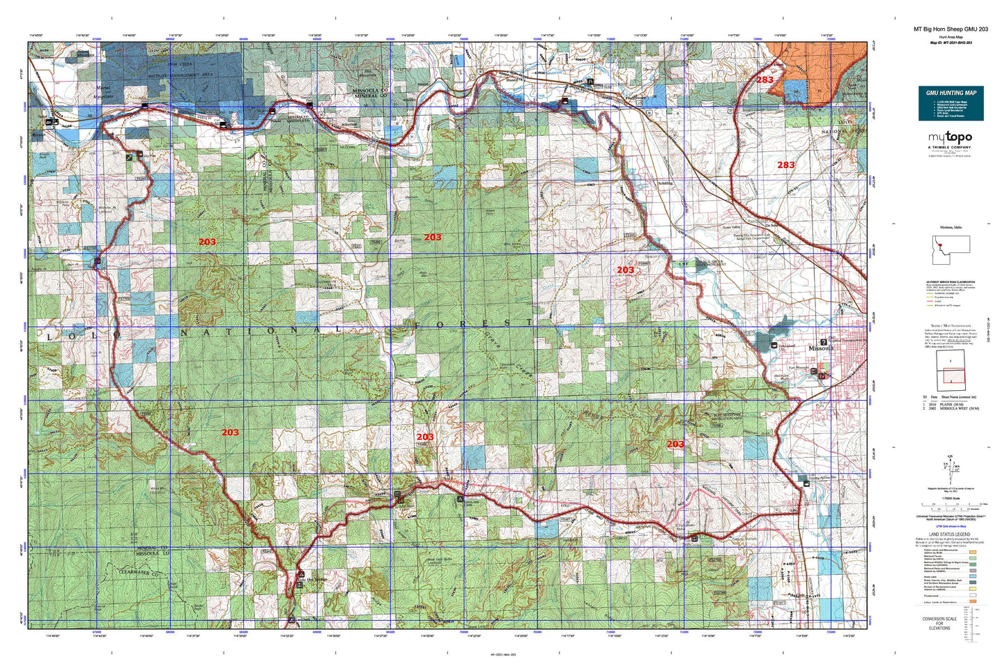
Hunting unit map of Montana Game Management Unit BHS-203 with topographic lines and unit boundaries. This topo map features UTM / MGRS and Latitude/Longitude grids, plus public land ownership. It comes folded on waterproof paper. Be fully prepared for your hunt with a MyTopo GMU map!.
This map contains the following named places: 11N23W07ABDB01 Spring,13N20W06AA__03 Well,13N20W08CBB_01 Well,13N20W08DA__01 Well,13N20W17BB__01 Well,13N21W01DCAD01 Well,13N21W11AADC01 Well,14N20W29DCCA01 Well,14N20W30CC__01 Well,14N20W31AA__01 Well,14N20W31BB__01 Well,14N20W31BD__01 Well,14N20W31DA__01 Well,14N20W31DB__01 Well,14N20W31DD__01 Well,14N20W32BB__01 Well,14N20W32CB__01 Well,14N20W32CB__02 Well,14N20W32DC__01 Well,14N20W32DCCA01 Well,14N21W25BCAC01 Well,14N21W25CADD01 Well,14N21W25CADD02 Well,14N21W25CBA_01 Well,14N21W25CBA_02 Well,14N21W25CCDA01 Well,14N21W25CCDA02 Well,14N21W25DA__01 Well,14N21W25DD__01 Well,14N21W36BD__01 Well,14N21W36DD__01 Well,59804,59820,Albert Creek,Albert Point,Alberton,Alberton Division,Anderson Gulch,Bear Creek,Bear Gulch,Beaver Slough Creek,Big Flat,Big Pine Campground,Big Pine Fishing Access Site,Big Pine Recreation Site,Bill Creek,Black Mountain,Blue Mountain,Blue Mountain Lookout,Blue Mountain Saddle,Bruce Creek,Burdette Creek,Cache Creek,Camillia Gulch,Camp Creek,Cedar Creek,Cedar Run Creek,Chickaman Gulch,Chickaman Mine,Chicken Creek,Chief Joseph Gulch,Circle S Ranch,Clark Creek,Cloudburst Creek,Cooley Gulch,Cooper Creek,Coppersmith Mine,Council Grove,Council Grove State Park,Cyr,Cyr Bridge Fishing Access Site,Cyr Census Designated Place,Cyr Flats,Cyr Gulch,Cyr Peak,Davis Creek,Deep Creek,Deep Creek Fishing Access Site,Deer Creek,Deer Peak,Diamond Point,Disappointment Creek,Dog Gulch,Dry Gulch,East Fork Grave Creek,East Fork Petty Creek,Eddy Creek,Eds Creek,Elderberry Gulch,Emma Gulch,Erskine Fishing Access Site,Fish Creek,Fish Creek Cemetery,Forks Fishing Access Site,Forks Recreation Site,Fort Fizzle,Fort Fizzle Campground,Fort Fizzle Historic Site,French Gulch,Frenchtown Irrigation District Ditch,Futter Gulch,Garden Creek,Garden Point,Gaspard,Gilman,Gilman Creek,Granite Creek,Granite Springs,Grass Valley French Ditch,Grave Creek,Grave Creek Meadow,Grave Creek Range,Grovedale,Hagerty Gulch,Hamilton Nine,Hay Creek,Hebert,Helean Camp,Hollensteiner Gulch,Howard Creek,Howard Creek Meadows,Hungry Creek,Hyde Creek,Indian Gulch,Inverness Group Mine,John Creek,Johns Creek,Kirchey Creek,La Valle Creek,Largest Pine in Montana Point of Interest,Lawyers Combination,Lawyers Combination Mine,Lewis and Clark Campground,Lick Gulch,Lion Creek,Lion Point,Little Martin Gulch,Lolo Creek Mine,Lolo Division,Lolo Hot Springs,Lolo Ranger Station,Lothrop,Lupine Creek,Madison Gulch,Mailbox Gulch,Marshall Creek,Martin Creek,Martin Gulch,Martin Point,Martin Spring,Mellady,Mike Creek,Mill Creek,Mill Creek Mine,Mill Creek Trail,Montana Creek,Moose Creek,Mormon Peak,Moulton Reservoir Number Two,Mouth of Fish Creek Fishing Access Site,North Creek,North Fork Howard Creek,O Neil Creek,O'Keefe Creek,Oriole Creek,Oriole Creek Trail,Owl Creek,Peppard Gulch,Petty Creek,Petty Creek Fishing Access Site,Petty Mountain,Pilot Knob,Plateau,Potato Gulch,Powell Creek,Primrose,Reservoir Creek,River Edge Resort,Rock Creek,Ross,Ruben Gulch,Sawmill Gulch,Schilling,Schilling Siding,Schoolhouse Gulch,Shangville,Sheldon,Sheldon Creek,Sheldon Mine,Sherman Gulch,Sherman Gulch Beacon,Slaughterhouse Gulch,Small Creek,Smith Creek,South Fork Fish Creek,South Fork Lolo Creek,South Fork Petty Creek,South Fork White Creek,Spring Gulch,State Line Trail,Sullivan Creek,Surveyors Creek,Tank Creek,Telephone Butte,Teller Barite Mine,Tepee Creek,Tepee Ridge Trail,Tevis Creek,Thompson Creek,Town of Alberton,Trail Creek,Triantler,Triantler Mine,Tucker Gulch,Upper Lolo Creek Mine,Upper Triantler Mine,Wagon Wheel Trailer Court,Wall Canyon Creek,Warm Slough,West Fork Butte,West Fork Butte Creek,West Fork Butte Lookout,West Fork Petty Creek,Westerman Creek,Wheeler Barite Mine,White Creek,White Mountain,Wig Creek,Wild Horse Point,Williams Pass,Williams Peak,Williams Peak Lookout,Williams Preston Hovet Ditch,Woodman Creek,Woodman Mine