MyTopo
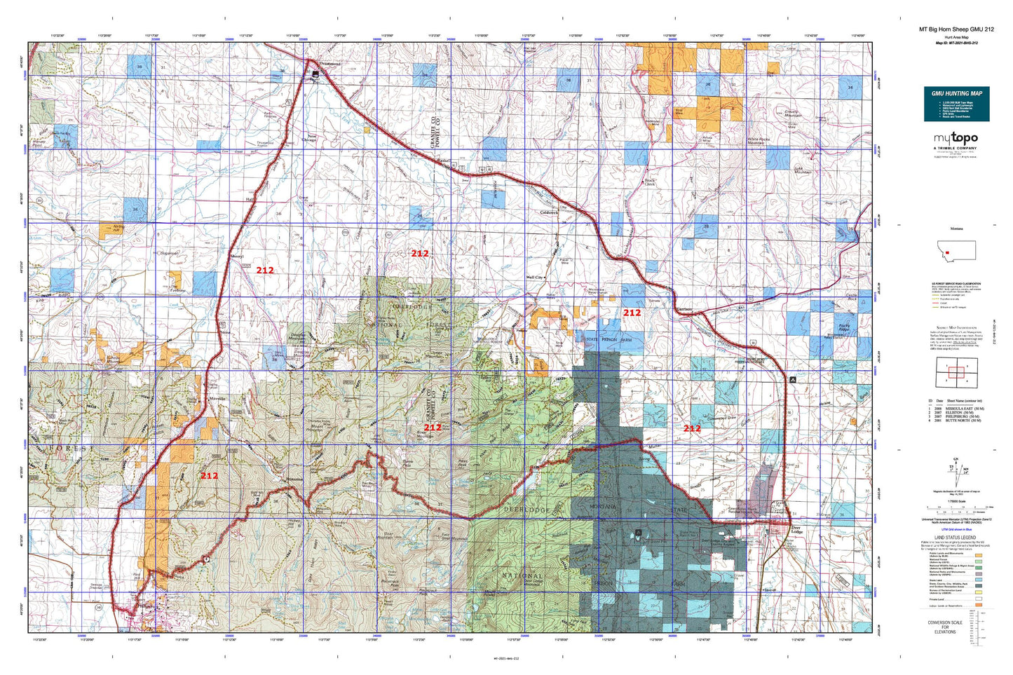
Montana Big Horn Sheep GMU 212 Map
Couldn't load pickup availability
Hunting unit map of Montana Game Management Unit BHS-212 with topographic lines and unit boundaries. This topo map features UTM / MGRS and Latitude/Longitude grids, plus public land ownership. It comes folded on waterproof paper. Be fully prepared for your hunt with a MyTopo GMU map!.
This map contains the following named places: 59731,59733,59837,Achegan Mine,Allen Dale Ditch,Allendale Ditch,Altoona Lakes,Altoona Lakes Mine,Anderson Dam,Anderson Mine,Ballard Hill,Barnes Creek,Bennett,Bert Creek,Bielenberg Lake,Big Bend,Bluebird Mine,Blum Creek,Boulder,Boulder Creek,Boulder Lakes Trail,Brand Ditch,Brock Creek,Brooklyn Mine,Bunker Hill Mine,Byrne Creek,Carten Creek,Cominco Phosphate Mine,Conleys Lake,Conleys Lake Dam,Conn Ditch,Conn Ranch,Copper Creek,Copper Creek Mine,Copper State Mine,Cottonwood Creek,Cow Creek,Crevice Creek,Davidson Creek,Death Road Mine,Deer Lodge Golf Club,Deer Lodge Mountain,Deerlodge Basin,Dixie,Dolus Creek,Dolus Lakes,Doney Lake,Doney Lake Dam,Dooley Ditch,Douglas Creek,Douglas Creek Cabin,Douglas Mountain,Dunkleberg Creek,Dunkleberg Ridge,Dutton,East Fork Brock Creek,East Goat Mountain,Elbow Lake,Elephant,Emery Ridge,Emmettsburg,Eureka Ridge,Eureka Ridge Mine,Fields,Finley Basin,Forest Rose Mine,Garrison,Gaskill Creek,Gird Creek,Gird Creek Mine,Goat Mountain,Goat Mountain Lakes,Gold Creek,Gold Creek Lakes,Gold Creek Mine,Gold Creek Placer Mine,Gold Hill Mine,Gold Lake Dam,Gold Reef,Goldberg East Dam,Goldberg Reservoir,Goldberg West Dam,Goldcreek,Gough Creek,Granite Creek,Grant Mine,Griffin Creek,Hagan Pond,Hall,Ham Gulch Mine,Haskell,Hattie Mine,Henderson,Henderson Creek,Henderson Mountain,Hickey Hill,Hoover Creek,Horseshoe Basin,Independence Creek,Ivanhoe Mine,Jackson Park,Jackson Park Mine,Jens,Jones Mountain,Kerns Lake,Kerns Lake Dam,Kohrs and Bielenberg Ditch,La Marche Creek,Limestone Ridge,Lingenpolter,Little Blackfoot River,Little Gold Creek,Lloyd,Londonderry Mine,Lone Tree Hill,Lower Taylor Reservoir,Lower Willow Creek,Lower Willow Creek Dam,Lower Willow Creek Reservoir,Marshall Creek,Martin Lake,Martin Lake Dam,Master Mine,Master Mining Camp,Maxville,Maywood Ridge,McLean Creek,Meadow Lakes,Middle Fork Douglas Creek,Middle Fork Mine,Moonlight Mine,Moose Lake,Mount Princeton,Mud Lake,Mud Lake Dam,Nabbs Spur,NE Section 15 Mine,NE Section 23 Mine,NE Section 7 Mine,NE SW Section 17 Mine,New Chicago,New Seattle Mine,Nirling Hill,Nonpareil Mine,North Fork Douglas Creek,North Fork Lower Willow Creek,North Gold Creek,North Star Mine,North Sunrise Mine,NW Section 14 Mine,Old China Ditch,Pauly Ditch,Perkins Creek,Phosphate,Pierre Hill,Pikes Peak,Pikes Peak Creek,Pineau Mine,Pioneer,Placer Mine,Placer Mines,Port Royal Mine,Powell Lake,Princeton,Princeton Mine,Princeton Placer Mine,Racetrack Peak,Rainbow Lake,Randalls,Red Cloud Mine,Red Hill,Relyea Mine,Riverfront RV Park,Rock Creek,Rock Creek Ditch,Rock Creek Falls,Rock Creek Lake,Rock Creek Lake Dam,Rose Mountain,Roth Hall,Royal,Royal Basin Mine,Royal Gold Creek,Ryan Mine,Saranac Mine,Sawmill Creek,Sawmill Creek Mine,SE Section 12 Mine,SE Section 14 Mine,SE Section 15 Mine,SE Section 33 Mine,SE Section 5 Mine,Sharkeyville,Sherryl,Silver La Donna Mine,Smart Creek,Snow Cap Mine,Snowcap Mine,South Boulder Creek,South Fork Douglas Creek,South Fork Lower Willow Creek,South Fork Rock Creek,South Gold Creek,Southern Flint Creek Valley Historical Marker,Spring Ranch,State Prison Ranch Number 1,Stewart Lake,Stone,Sugarloaf,Sunrise,Sunrise Mine,Sunrise Mountain,Sunrise/Queen Mine,SW Section 14 Mine,SW Section 7 Mine,Swamp Gulch Creek,The Eyebrow,Thompson Lake,Thursday Friday Mine,Tibbets Mine,Tin Cup Lake,Tin Cup Lake Dam,Tolean Lake,Toohy,Trask Lakes,Travonia Mine,Upper Taylor Dam,Upper Taylor Reservoir,Wall City,Warm Springs Creek,Wasa Mine,West Fork Lower Willow Creek,Willow Creek,Wolling Wighter Dam,Yamhill