MyTopo
Montana Big Horn Sheep GMU 300 Map
Couldn't load pickup availability
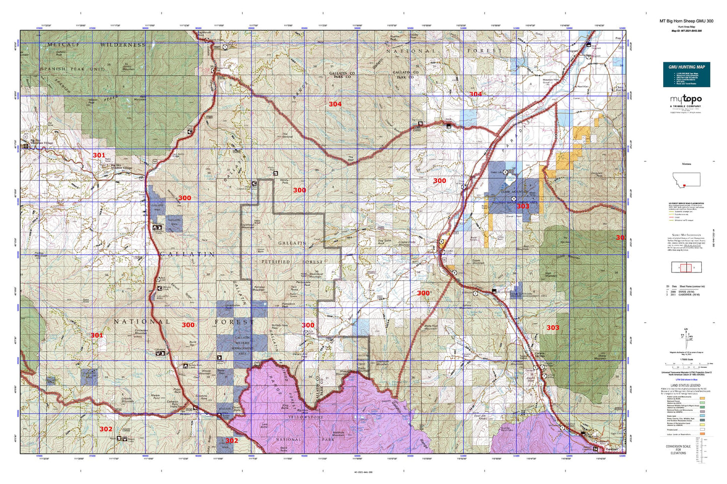
Hunting unit map of Montana Game Management Unit BHS-300 with topographic lines and unit boundaries. This topo map features UTM / MGRS and Latitude/Longitude grids, plus public land ownership. It comes folded on waterproof paper. Be fully prepared for your hunt with a MyTopo GMU map!.
This map contains the following named places: 59027,59730,Absaroka-Beartooth Wilderness Historical Marker,Albino Lake,Aldridge,Aldridge Creek,Aldridge Lake,Almart,Almart/Walton Mine,Asbestos Creek,B K Ranch,Bark Cabin Creek,Bear Basin,Bear Creek,Beaver Creek,Big Creek,Big Creek Station,Big Horn Peak,Big Sky,Big Sky Canyon Village,Big Sky Division,Big Sky Golf Course,Big Sky Meadow Village,Big Sky Mobile Home Court,Black Mountain,Buck Creek,Buffalo Horn Campground,Buffalo Horn Creek,Buffalo Horn Lakes,Buffalo Horn Station,Burnt Top,Cache Creek,Cameron Point,Canary Bird Peak,Canyon Creek,Carbella,Carbella Campground,Carbella Recreation Site,Cascade Lakes,Cedar Creek,Cinnabar Basin,Cinnabar Creek,Cinnabar Mountain,Cinnamon Creek,Cinnamon Mountain,Cinnamon Station,Cliff Creek,Cooper Bench,Cottonwood Creek,Covered Wagon Ranch,Crag Lake,Crail Creek,Crail Ranch,Crescent Lake,Crown Butte,Crystal Cross Mountain,Cutler Lake,Dailey,Dailey Basin,Dailey Lake,Dailey Lake Campground,Dailey Lake Fishing Access Site,Deadhorse Creek,Deaf Jim Creek,Deaf Jim Knob,Deer Creek,Deer Lake,Divide Creek,Divide Trail,Dixon Creek,Doe Creek,Dog Tooth Rock,Dome Mountain,Donahue Creek,Dry Creek,Dudley Creek,Dudley Creek Mine,Dudley Lake,Eaglehead Mountain,Eldridge,Eldridge Cabin,Eldridge Creek,Elkhorn Creek,Elkhorn Ranch,Emigrant Rest Area,Ferrell Creek,Ferrell Lake,First Creek,First Yellow Mule Creek,Fisher Creek,Flints Creek,Fortress Mountain,Fourth Creek,Gallatin Petrified Forest,Gallatin State Wildlife Management Area,George Norman Trailer Court,Golden Trout Lakes,Goldmeyer Creek,Goose Creek,Green Lake,Grizzly Creek,Grouse Mountain,Half Way Inn,Hell Roaring Lake,Hidden Creek,Hidden Lakes,High Lake,Hoppe Creek,Horse Creek,Hyalite Creek,Joe Brown Creek,Karst Ranch,King Butte,Kotke,Lake Elsie,Lazy T 4 Ranch,Left Fork Deadhorse Creek,Lemondrop,Levinski Creek,Lewis Creek,Lincoln Mountain,Lion Creek,Little Bear Creek,Little Donahue Creek,Little Joe Lake,Little Spring Creek,Lizard Lakes,Lone Indian Peak,Lower Basin,Mans Foot Mountain,Marble Lake,Marble Point,McGill Campground,Meadow Creek,Merrell Dam,Merrell Lake,Michel Ranch,Michener Creek,Middle Basin,Middle Creek,Middle Fork Cottonwood Creek,Middle Fork West Fork Gallatin River,Mill Creek,Mill Fork,Miner,Mist Creek,Moon Lake,Mount Chipperfield,Mulherin,Mulherin Creek,Nine Quarter Circle Ranch,North Fork Cottonwood Creek,North Fork Porcupine Creek,North Fork West Fork Gallatin River,Onion Basin,Ousel Falls,Ousel Falls Recreation Site,Ox Yoke Ranch,Packsaddle Peak,Pine Creek,Point of Rocks Fishing Access Site,Porcupine Creek,Porcupine Forest Service Station,Porcupine Ranch,Portal Creek,Prohibition Rock,Pulpit Rock,Rainbow Ranch,Ramshorn Lake,Ramshorn Peak,Red Cliff Camp,Reeder Creek,Rhyolite Mine,Rock Creek,Sage Creek,Sawtooth Mountain,Second Creek,Second Yellow Mule Creek,Sedge Lake,Shady Rest Camp,Sharp Creek,Sheep Creek,Sheep Mountain,Shelf Lake,Shooting Star Lake,Shooting Star Mountain,Skully Creek,Slide Creek,Slip and Slide Creek,Slip and Slide Fishing Access Site,Smith Ranch,Smokey Creek,Soldier Creek,South Fork West Fork Gallatin River,South Glastonbury,Sphinx,Sphinx Creek,Sphinx Mountain,Stands Basin,State Game Range Headquarters,Steamboat Mountain,Steele Creek,Stoughten Creek,Sunlight Creek,Sunshine Point,Table Mountain,Table Mountain Mine,Tamphery Creek,Taylor Creek,Tepee Creek,The Bear,The Blowout,The Sentinel,Thelma Number 1 Dam,Thelma Number 2 Dam,Third Creek,Three Hundred and Twenty Ranch,Tom Miner Basin,Tom Miner Campground,Tom Miner Creek,Trail Creek,Trestle Ranch,Twin Cabin Creek,Twin Lakes,Twin Peaks,Twin Peaks Creek,Walsh Creek,Wapiti Creek,West Fork Gallatin River,Wigwam Creek,Wilson Peak,Windy Pass Forest Service Station,Yankee Jim Campground and Picnic Area,Yankee Jim Canyon Point of Interest,Yankee Jim Lake