MyTopo
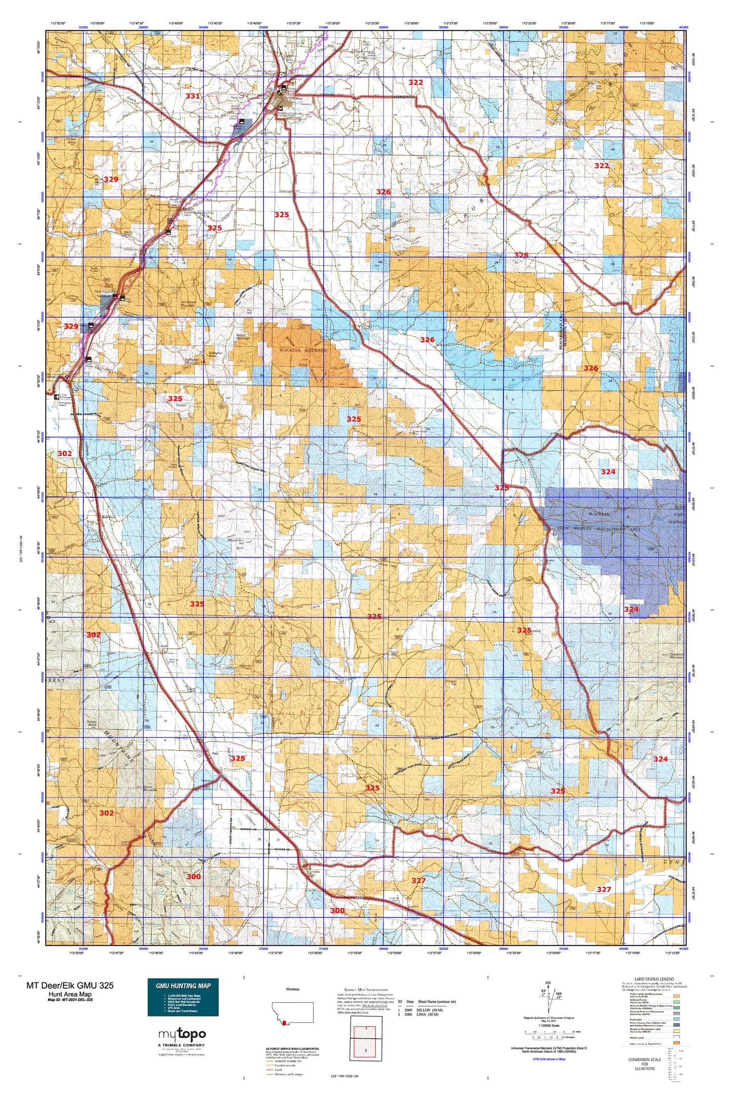
Montana Deer/Elk GMU 325 Map
Couldn't load pickup availability
Hunting unit map of Montana Game Management Unit DEL-325 with topographic lines and unit boundaries. This topo map features UTM / MGRS and Latitude/Longitude grids, plus public land ownership. It comes folded on waterproof paper. Be fully prepared for your hunt with a MyTopo GMU map!.
This map contains the following named places: 59724,A L Gilbert Company Elevator,Abenson Dam,Alkali Creek,Andersen Ranch,Ashbaughs Saloon,Ashbough Canyon,Axes Canyon,Axes Canyon Mine,Ball Ranch,Bannack Historical Marker,Barretts,Barretts Dam,Barretts Park Campground,Barretts Rest Area,Barretts Station Park,Basin Creek,Bear Gulch,Beaverhead County Fairgrounds,Beaverhead Golf Club,Beech Creek,Benson Peak,Benson Ranch,Big Sheep Creek,Big Spring Gulch,Bill Hill Creek,Bishop Place,Blacktail,Blacktail Deer Creek,Blacktail Mountains,Boulder Gulch,Briggs Ranch,Brock Creek,Brown Ranch,Buck Creek,Buggy Gulch,Bull Creek,Bunton and Parish Stage Station,Burnt Willow Creek,C and C Farm and Ranch Supply Elevator,Cabin Creek,Canyon Ditch,Carico Ditch,Cattle Creek,Cedar Gulch,Centennial Park,Centennial Valley,Chris Cabin,Christensen Ranch,Chute Canyon,City of Dillon,Clarks Lookout State Park,Clover Divide,Conover Ranch,Cooks Lake,Cornell Park/Kiwanis Family Project,Cornell Ranch,Corrals Fishing Access Site,Cottonwood Creek,Coyote Canyon,Crampton Ranch,Crazy Springs Creek,Crittenden Creek,Crooked Creek,Dalys,Dan Ibey Memorial Park,Deadwood Gulch,Dell,Dell - Red Rock Rest Area,Dell Park,Dillon,Dillon Canal,Dillon Division,Dillon KOA Kampground,Dillon Reservoir,Dillon Sewage Lagoon Dam,Divide Creek,Dixon Mountain,Dry Canyon,Dry Hill,East Bench,East Bench Grain and Machinery Incorporated Elevator,East Creek,East Fork Blacktail Deer Creek,East Fork Clark Canyon,Elk Gulch,Ermont Gulch,Express Creek,Fairview,Flynn Brothers Ranch,Ford,G B Shaffner Ranch,Gallagher Butte,Gallagher Creek,Gallagher Creek Station,Gallagher Mountain,Girl Scout Shelter,Glendale,Gosman,Graphite Birds Nest Mine,Grasshopper Creek,Ground Hog Mine,Guidici Cowcamp,Guntner Place,Hands Ditch,Hans Dons Ranch,Hawkins Ranch,Heifer Creek,Hidden Pasture Creek,Hidden Pasture Trail,Hoffman Place,Hoffman Place Mine,Holden Place,Horseshoe Lake,Irishmans Hole,Jake Canyon,Jake Canyon Creek,Jaycee Park,Jim Brown Mountain,Junction Creek,Kidd,Kidd Pit Mine,Knox Ranch,Landon Ranch,Left Fork Stone Creek,Lima Dam,Little Ashbough Canyon,Little Basin Canyon,Little Basin Creek,Little Elk Gulch,Little Sage Creek,Little Sheep Creek,Little Spring Gulch,Little Water Canyon Mine,Long Creek,Long Gulch,Lovell Island,Lovells Gulch,Lovells Lake,Mass Canyon,McKnight,Middle Fork Blacktail Deer Creek,Middle Fork Gallagher Creek,Middle Fork Stone Creek,Mine Gulch,Mine Gulch Mine,Monument Hill,Mooney Mountain,Mooney Ranch,Moose Creek,Museum and Depot Park,NE NE Section 26 Mine,NE SE Section 19 Mine,Nevada Mine,North Fork Sweetwater Creek,NW NE Section 12 Mine,NW Section 24 Mine,Old Trail to the Gold Diggins Historical Marker,O'Neils Station,Owen Ditch,Perkins Ditch,Pipe Organ Lodge,Pipe Organ Rock,Pistol Creek,Poindexter,Poindexter Slough,Poindexter Slough Fishing Access Site,Poison Gulch,Price Canyon,Price Creek,Rattlesnake Creek,Ray Lynch Park,Rebich Ranch,Red Butte,Red Canyon,Red Rock,Regal Mine,Retort Mountain,Riley Canyon,Rock,Rock Creek,Rock Island Ranch,Ruby Range,Sage Creek,Sawyer,SE NE Section 13 Mine,Selway Park,Sheep Creek,Sierra Strip Mine,Silver Queen Mine,Sim Estes Station,Skl-ow-kin Creek,SkyLine RV Park,Small Horn Canyon,Smith Dillon Mine,Smith Island,Smith Rebich Ditch,Smith Slough,Snowbank Ridge,Sorensen Ranch,South Side Reservoir,Southside RV Park,Steamboat Rock,Stefonic Ranch,Stone Creek Mine,Sweetwater Basin,Tallent Ranch,Teddy Creek,Tendoy Mountains,The Basin,The Iron Mine,Timber Creek,Timber Hill,Tri-State Strip Mine,Tulley Ditch,Van Camp Canyon,Van Camp Ditch,Van Camp Slough,Veterans Memorial Park,Vigilante Park,Vinegar Hill,Wagner Creek,West Fork Beech Creek,West Fork Blacktail Deer Creek,West Fork Sheep Creek,West Side Park,Weston Canyon,Wheat Ranch,Whippoorwill Creek,Whiskey Draw,Whiskey Spring,White Hills,Willow Spring,Winnipeg Creek,Wood Canyon