MyTopo
Montana Deer/Elk GMU 390 Map
Couldn't load pickup availability
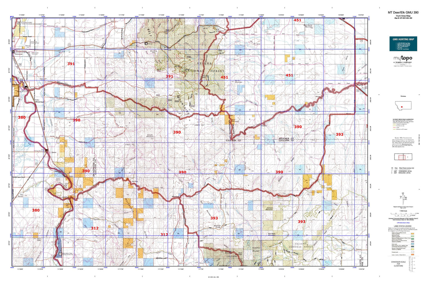
Hunting unit map of Montana Game Management Unit DEL-390 with topographic lines and unit boundaries. This topo map features UTM / MGRS and Latitude/Longitude grids, plus public land ownership. It comes folded on waterproof paper. Be fully prepared for your hunt with a MyTopo GMU map!.
This map contains the following named places: 04N02E04AB__01 Well,04N02E10BB__01 Well,04N02E16AA__01 Well,04N02E16AAA_01 Well,04N02E35CC__01 Spring,04N03E06DDAB01 Spring,05N02E02BB__01 Well,05N02E02CB__01 Well,05N02E03AC__01 Well,05N02E03ACDC01 Well,05N02E03DA__01 Well,05N02E03DA__02 Well,05N02E04DB__01 Well,05N02E04DBDA01 Well,05N02E10AD__01 Well,05N02E10ADDD01 Well,05N02E10CBCC01 Well,05N02E10DA__01 Well,05N02E11BC__01 Well,05N02E14DD__01 Well,05N02E15AC__01 Well,05N02E15DA__01 Well,05N02E15DA__02 Well,05N02E15DA__03 Well,05N02E15DACB01 Well,05N02E16DB__01 Well,05N02E21AD__01 Well,05N02E21DA__01 Well,05N02E22AD__01 Well,05N02E22BB__01 Well,05N02E22BD__01 Well,05N02E22CBBA01 Well,05N02E22DB__01 Well,05N02E23BBDA01 Well,05N02E23BD__01 Well,05N02E23CA__01 Well,05N02E23CA__02 Well,05N02E23CA__03 Well,05N02E23CA__04 Well,05N02E23CA__05 Well,05N02E23CA__06 Well,05N02E23CB__01 Well,05N02E23DB__01 Well,05N02E23DBBB01 Well,05N02E23DBCA01 Well,05N02E23DC__01 Well,05N02E23DC__02 Well,05N02E23DC__03 Well,05N02E26AC__01 Well,05N02E26BD__01 Well,05N02E26CA__01 Well,05N02E26CA__02 Well,05N02E26CA__03 Well,05N02E27AD__01 Well,05N02E27ADDA01 Well,05N02E27BB__01 Well,05N02E27BB__02 Well,05N02E27BB__03 Well,05N02E27BB__04 Well,05N02E27BC__01 Well,05N02E27CC__01 Well,05N02E27DD__01 Well,05N02E28ACDA01 Well,05N02E28AD__01 Well,05N02E28CDDD01 Well,05N02E33AA__01 Well,05N02E33AB__01 Well,05N02E33AC__01 Well,05N02E33DACA01 Well,05N02E34AADD01 Well,05N02E34BA__01 Well,05N02E35BA__01 Well,05N02E35DAB_01 Well,05N03E06AA__01 Well,06N02E34AD__01 Well,06N02E34AD__02 Well,06N02E34CA__01 Well,06N02E34CA__02 Well,06N02E34CD__01 Well,06N02E34DC__01 Well,06N02E34DD__01 Well,06N03E32DD__01 Well,06N03E34AC__01 Well,A Doig Ranch,A Frame Spring,Adolph Creek,Battle Creek,Battle Mountain,Battle Mountain Creek,Bean Canyon,Bearskull Creek,Big Spring,Big Springs Ditch,Bigler Mine,Black Butte,Blacktail Divide,Boone Run,Bremmer Creek,Brewer,Broadwater - Missouri Canal,Broadwater County Fair and Rodeo Grounds,Bullrock Spring,Cable Gulch,Canyon,Cardinal,Cedar Hill,Cedar Hollow,Christison Ranch,Coal Gulch,Daniels Cow Camp,Deep Creek,Deep Creek Cemetery,Deep Creek Pavillion,Deep Creek Picnic Area,Deer Park,Devils Bottom,Devils Bottom Mine,Diamond Gulch,Doig Ranch,Dry Creek,Dry Fork,Dry Hollow,Dunbar Springs,Eastham Spring,Elkhorn Ridge,Ellison Flat,Fairchild Ditch,Fanalulu,Farley Gulch,Farley Spring,Faulkner Creek,Flathead Indian Trail,Fleming,Flume Hollow,Francis,Francis Ranch,Garden Gulch,Goodell,Grassy Mountain,Grouse Mountain,Hatfield Mountain,Hatfield Ranch,Haw Gulch,Hay Creek,Hayfield Creek,High Peak,Holker,Holy Cross Cemetery,Horse Creek,Indian Creek,Jensen Ranch,Kieckbusch Ranch,Klondike Pass,Koenig Ranch,Lang Canyon,Lippert Gulch,Little Creek,Lombard,Lombard Canal,Lombard Hill,Lone Pine Gulch,Maudlow,Maxwell Canyon,Meyers Gulch,Middle Fork Canyon,Middle Fork Creek,Middle Fork Sixteenmile Creek,Mike Day Creek,Miller Gulch,Miller Ranch,Miners Gulch,Missouri River Grain Company Elevator,Mitchell Ranch,Mud Spring,Mule Creek,Munding Flat,Nathan,Nicks Gulch,North Fork Deep Creek,Olie Canyon,Paddys Run,Painted Canyon,Pole Gulch,Ponderosa Pines Census Designated Place,Prescott Ranch,Quarry Gulch,Quarry Spring,Quaw Creek,Red Rock Mountain,Robertson Ranch,Rocky Canyon,Ross Gulch,Round Pole Corrals,Rowland Spring,Roy Gulch,Running Deer Creek,Rye Grass Creek,Sawmill Gulch,Shaft Near Lombard Mine,Shendell Number 2 Dam,Sherlock Creek,Sherlock Mountain,Shull,Sixmile Creek,Sixmile Mountain,Sixteen,Sixteenmile Canyon,Sixteenmile Creek,Small Adit Mine,Snowbank Mine,Snowslide Creek,South Fork Sixteenmile Creek,South Fork Trail,Spring Gulch,Stanley,Stanton Gulch,Table Mountain,Timber Gulch,Toston,Toston Census Designated Place,Toston Dam,Toston Dam Campground,Toston Fishing Access Site,Toston Mine,Toston Tunnel,Townsend Reservoir,Troy Creek,Troy Ranger Station,Two Dollar Bill Dam,Wall Mountain,Welch Ranch,Whiskey Gulch,Williams Ranch,Williams Spring,Windsor Gulch