MyTopo
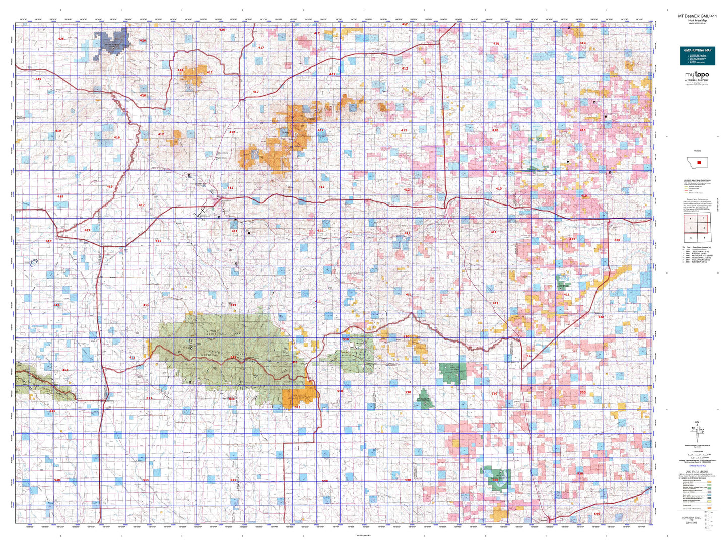
Montana Deer/Elk GMU 411 Map
Couldn't load pickup availability
Hunting unit map of Montana Game Management Unit DEL-411 with topographic lines and unit boundaries. This topo map features UTM / MGRS and Latitude/Longitude grids, plus public land ownership. It comes folded on waterproof paper. Be fully prepared for your hunt with a MyTopo GMU map!.
This map contains the following named places: Akerville,Allen Ranch,Amherst,Andersonville,Armells,Ayers Ranch Colony,Bald Butte,Barrows,Battrick,Baxter,Bear Creek Reservoir,Beaver Creek,Becket,Bercail,Big Casino Creek Reservoir Fishing Access Site,Big Grassy Peak,Black Butte,Blake Creek Forest Station,Blakeslee,Box Springs,Brewery Flats Fishing Access Site,Brodie,Brooks,Buffalo,Burnette Peak,Button Butte,Camp Lewtana,Canyon,Carroll Trail Fishing Access Site,Carters Pond,Castle Butte,Castle Hill Ski Area,Chamberlain,Cheadle,Chippewa,City of Judith Gap,City of Lewistown,Collar Peak,Cone Butte,Corbly,Cottonwood,Crystal Lake,Crystal Lake Boat Launching,Crystal Lake Campground,Crystal Lake Guard Station,Crystal Lake Picnic Area,Crystal Peak,Dallas,Danvers,Darrel,D'Autremont Complex,Deerfield Colony,Des Moines Lakes,Devils Hole Lake,Doughty,Dry Lake,Dryland,Dunlap,East Fork Reservoir,Eddies Corner,Eddies Corner Incorporated Campground,Elk Peak,Elks Country Club,Emory,Farmers Elevator,Fergus Athletic Field,Fergus County,Fergus County Fairgrounds,Flat Mountain,Flatwillow Colony,Fords Creek,Fords Creek Colony,Forestgrove,Fort Maginnis Historical Marker,Fort Sherman,Frank Day Park,Fred Robinson Park,Garneill,Garneill Elevator,Giltedge,Glengarry,Gold Hill,Grand View Recreation Site,Grass Range,Grass Range City Park,Grass Range Division,Greathouse Peak,Hanover,Hanover Division,Harvest States Cooperatives Elevator,Hauck,Hawthorne Park,Heath,Heath Station,Hilger,Hoosac,Hruska Fishing Access Site,Indian Graves Butte,Jackman,Janeauxs Post,Jaycees Park,Joan,Judith Basin Country Historical Marker,Judith Gap,Judith Gap Junction,Judith Park,Judith Peak,Jump Off Peak,Kelly Hill,Kendall,King Ranch Colony,Kingston,Kiwanis Camp,Kiwanis Club Campground,Kiwanis Park,Kolin,Lake Mason,Lake Mason National Wildlife Refuge,Lake Thom,Lewis Peak,Lewis Ranch,Lewistown,Lewistown Division,Lewistown Elks Country Club,Lewistown Heights,Lewistown Historical Marker,Lewistown Junction,Lime Cave Peak,Little Montana Truckstop Campground,Living Springs,Lode Reservoir,Lookout Peak,Lost Peak,Lower Carter Pond Fishing Access Site,Lyons Butte,Maginnis Mountain,Maiden,Maiden Fur Farm,Maiden Peak,Maidens Gold Historical Marker,May Martin Lake,McCall-Webster Elevator,McClave,McDonald Butte,McDonnell,McLean Elevator,McLean Lake,Mendon,Mennonite,Mill Ditch Park,Miller Lake,Montana and Dakota Elevator,Montana Elevator,Moore,Moore City Park,Mount Harlow,Mountain Acres Mobile Home Park,Mountain Acres RV Park and Campground,N Bar Ranch,Nelson,New Year,New Year Peak,Nihill Siding,Novary,Oka,Oka Butte,Old Baldy,Orange,Oxford,Peavey Company Elevator,Pekay Peak,Pine Ridge,Piper,Porphyry Peak,Pyramid Peak,Rattlesnake Butte,Red Hill,Red Mountain,Reed and Bowles Trading Post,Roberta,Rockford,Rocky,Rocky Butte,Romundstad,Ross Fork,Rothiemay,Roundup Division,Roy Junction,Roy-Winifred Junction,Ruby Gulch,Rustle,Sahara,Sahara Hill,Samples Crossing,Sand Rock Hill,Sawyers Trailer Park,Schumachers,Seright,Sheep Mountain,Sipple,Skaggs,Spotted Horse,Spring Creek Colony,Spring Creek Fishing Access Site,Spring Creek Junction,State of Montana,Steamboat Rock,Straw,Symmes Park,Talbot Lake,Teigen,Tepee Point,The Point,Three Buttes,Town of Grass Range,Town of Moore,Tyler,Upper Carter Pond Fishing Access Site,Upper Carters Pond,Valley View Castle Mobile Home Park,Wachusett,War Horse Lake,War Horse National Wildlife Refuge,Ware,Warm Spring Creek,Warr,Watson,West Evers Saw Mill,West Lewistown,West Peak,Westernaire Drive-In Theater,Wheaton,Wild Horse Lake,Wright,Yellow Water Reservoir