MyTopo
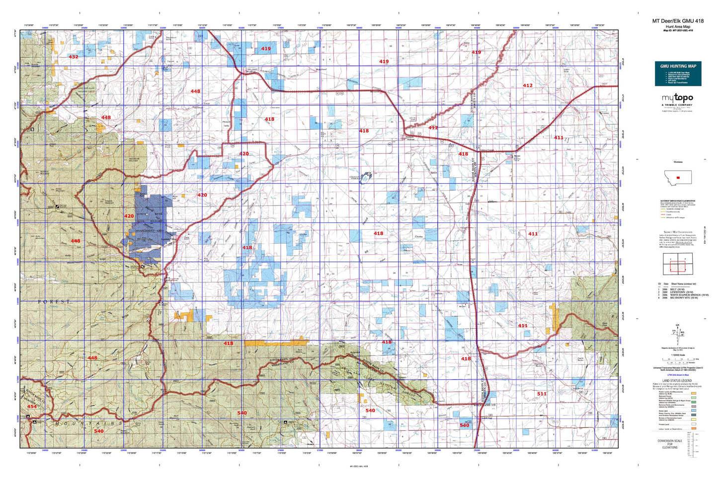
Montana Deer/Elk GMU 418 Map
Couldn't load pickup availability
Hunting unit map of Montana Game Management Unit DEL-418 with topographic lines and unit boundaries. This topo map features UTM / MGRS and Latitude/Longitude grids, plus public land ownership. It comes folded on waterproof paper. Be fully prepared for your hunt with a MyTopo GMU map!.
This map contains the following named places: 11N14E01AD__01 Spring,11N14E01AD__02 Spring,11N14E01BB__01 Spring,11N14E02AA__01 Spring,11N15E05AA__01 Spring,12N14E26CD__01 Spring,12N14E27AD__01 Spring,12N14E27CA__02 Spring,12N14E27CA__03 Spring,12N14E28DB__01 Spring,12N14E30CD__01 Spring,12N14E35CA__01 Spring,12N14E36AC__01 Spring,59418,59452,59479,Abbott Coulee,Ackley Lake,Ackley Lake Campground,Ackley Lake Dam,Ackley Lake Feeder Canal,Ackley Lake Outlet Canal,Ackley Lake State Park,Alice Coulee,American Mine,Antelope Creek,Antelope Gorge,Arch Coulee,Aries Dam,Atlas Dam,Barrows,Barrows Creek,Basin Creek,Bear Gulch,Bear Park,Belden Ditch,Big Coulee,Big Rock Creek,Blacktail Hills,Bluff Mountain,Bluff Mountain Creek,Bower Canyon,Browns Canyon,Buffalo,Buffalo Canyon,Buffalo Cemetery,Buffalo Creek,Bull Spring,Burley Creek,Burley Peak,Burris Creek,Bye-Bye Dam,Cabin Creek,Cameron,Carr Creek,Cecrle Number 1 Dam,City of Hobson,Coal Bank Coulee,Conan Coulee,Courtneys Creek,Coyote Creek,Cross Creek,Dallas,Dark Canyon,Dawkins Branch,Dawkins Springs,Deadhorse Creek,Deadman Coulee,Dipping Vat Coulee,Dolomites Dam,Dry Creek,Dry Gulch,Dry Pole Campground,Dry Pole Canyon,Dunsmore Coulee,East Antelope Creek,East Fork Mud Creek,Eddies Corner,Eddies Corner Incorporated Campground,Ellis Coulee,Ettien Gulch,Ettien Ridge,Ettien Spring,Farmer Spring,Farmers Elevator,Fred M Ellis Memorial Campground,Garneill,Garneill Cemetery,Garneill Elevator,General Mills Incorporated Elevator,Hauck,Hauck Coulee,Haven Reservoir Dam,Hay Canyon,Hay Canyon Campground,Hay Coulee,Haymaker Park,Heiserman Coulee,Hidden Lake,High Spring,High Spring Creek,Hobson,Hobson Division,Hobson Stop Trailer Court and RV Park,Hoover,Hopkins Coulee,Indian Hill,Indian Hill Campground,Iron King Mine,Joan,Judith Basin County,Judith Gap Junction,Judith Ranger Station,Judith River Game Range Headquarters,Judith River Historical Marker,Judith River State Wildlife Management Area,Kelly Coulee,Korells Dude Ranch,Larson Cemetery,Lehigh,Lehigh Cemetery,Little Trout Creek,Lost Fork Judith River,Martin Coulee,Marys Knoll,McCall-Webster Elevator,McClave,Meadow Creek,Mendon,Middle Fork Judith River,Middle Fork Rickard Coulee,Miller Brothers Livestock Reservoir Dam,Missouri Coulee,Mitchell Gulch,Mitchell Spring,Moccasin,Moccasin Cemetery,Moccasin Census Designated Place,Monk Coulee,Montana Elevator,Moore,Moore City Park,Moose Coulee,Mount High,Mud Creek,Murray Ditch,NE NE Section 8 Mine,Nickerson Coulee,North Fork Courtneys Creek,North Fork Rickard Coulee,North Fork Running Wolf Creek,North Fork Sage Creek,NW NE Section 16 Mine,NW NW Section 14 Mine,NW SE Section 20 Mine,NW SE Section 6 Mine,Oka Butte,Oka Coulee Spring,Old Yogo Town,Old Yogo Townsite Mine,Olsen Creek,Pagil Gulch,Peavey Company Elevator,Philbrook,Philbrook Cemetery,Pine Knob,Pleasant Valley,Pleasant Valley Cemetery,Red Bluff Creek,Red Hill,Red Shed Lake,Reed Hill,Rickard Coulee,Rocky,Rocky Gulch,Roughlock Hill,Rung Reservoir Dam,Running Wolf Deposit Mine,Russell Point,Russian Creek,Russian Flat,Russian Flat Airport,Saager Canyon,Sandpoint Creek,Saphire Mine,Sapphire Ridge Census Designated Place,Sapphire Village,Sawmill Canyon,Sawmill Gulch,Scholtztown,SE NW Section 16 Mine,SE SE Section 33 Mine,SE SE Section 6 Mine,Setter Creek,Sheep Mountain,Sipple,Sixshooter Spring,Skunk Gulch,Skunk Gulch Placer Mine,Smith Creek,South Fork Courtneys Creek,South Fork Judith River,South Fork Rickard Coulee,South Fork Running Wolf Creek,Spring Branch,Spring Creek,Spring Gulch,Stevens Butte,Straw,SW NW Section 10 Mine,SW NW Section 15 Mine,SW SE Section 33 Mine,Tepee Butte,Tollgate,Tollgate Mountain,Town of Moore,Trask Gulch,Trask Ranch,Twin Sisters,Ubet - Garneill Cemetery,Utica,Utica Cemetery,Utica Census Designated Place,Vortex Mine,Waite Creek,Waite Ditch,Weber Coulee,West Buffalo Creek,West Fork Antelope Creek,West Fork Mud Creek,Willow Park,Windmill Coulee,Woodhurst Mountain,Yogo Creek,Yogo Crossing