MyTopo
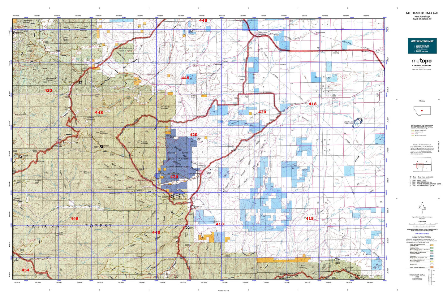
Montana Deer/Elk GMU 420 Map
Couldn't load pickup availability
Hunting unit map of Montana Game Management Unit DEL-420 with topographic lines and unit boundaries. This topo map features UTM / MGRS and Latitude/Longitude grids, plus public land ownership. It comes folded on waterproof paper. Be fully prepared for your hunt with a MyTopo GMU map!.
This map contains the following named places: 12N12E09CC__01 Spring,12N12E09CD__01 Spring,12N12E09DB__01 Spring,12N12E10AD__01 Spring,12N12E11AD__01 Spring,12N12E12BC__01 Spring,12N12E12CC__01 Spring,12N12E13AA__01 Spring,12N12E13DD__01 Spring,12N12E14DC__01 Spring,12N12E15AD__01 Spring,12N12E15CD__01 Spring,12N12E23AA__01 Spring,12N12E23BB__01 Spring,12N12E23BC__01 Spring,12N12E23DB__01 Spring,12N12E24AA__01 Spring,12N12E24BD__01 Spring,12N12E24CA__01 Spring,12N12E24CB__01 Spring,12N12E24DB__01 Spring,12N12E25AA__01 Spring,12N13E10BC__01 Spring,12N13E10BD__01 Spring,12N13E14AA__01 Spring,12N13E15DB__01 Spring,12N13E16DA__01 Spring,12N13E18DA__01 Spring,12N13E19BC__01 Spring,12N13E20CB__01 Spring,12N13E20DA__01 Spring,12N13E20DB__01 Spring,12N13E21AD__01 Spring,12N13E21CA__01 Spring,12N13E21DB__01 Spring,12N13E21DD__01 Spring,12N13E21DD__02 Spring,12N13E22AB__01 Spring,12N13E22AB__02 Spring,12N13E22AC__01 Spring,12N13E22BA__01 Spring,12N13E22CA__01 Spring,12N13E22CD__01 Spring,12N13E22CD__02 Spring,12N13E24AB__02 Spring,12N13E26BA__01 Spring,12N13E26BA__02 Spring,59452,59479,Abbott Coulee,Alice Coulee,American Mine,Antelope Gorge,Appraisal Creek,Arch Coulee,Bandbox Mountain,Basin Creek,Bear Gulch,Bear Park,Belden Ditch,Big Coulee,Big Spring,Blacktail Hills,Boulder Gulch,Bower Canyon,Browns Canyon,Burris Cabin,Burris Creek,Butcherknife Gulch,Butcherknife Mountain,Cabin Mountain,Cameron,Carr Creek,Cleveland Creek,Coal Bank Coulee,Conan Coulee,Courtneys Creek,Coyote Peak,Deadman Coulee,Deer Gulch,Democrat Gulch,Dipping Vat Coulee,Doerr Creek,Dry Gulch,Dry Pole Campground,Dry Pole Canyon,Dry Wolf Campground,Dry Wolf Ranger Station,East Antelope Creek,East Fork Stiner Creek,Elk Creek,Elk Saddle,Ellis Coulee,Ettien Gulch,Ettien Ridge,Ettien Spring,Flat Gulch,Fred M Ellis Memorial Campground,Geer Cemetery,Gibson Peak,Gold Bug Mine,Gravel Gulch,Halzell Coulee,Harrison Creek,Hay Canyon,Hay Canyon Campground,Hay Coulee,Heiserman Coulee,Hell Creek,Hobson Division,Hoover,Hopkins Coulee,Indian Hill,Indian Hill Campground,Iron Gulch,Iron King Mine,Judith Basin County,Judith Ranger Station,Judith River Game Range Headquarters,Judith River State Wildlife Management Area,Kelly Coulee,Kelly Mountain,King Creek,Korell Cabin,Korells Dude Ranch,Lake Elva,Larson Cemetery,Lead Gulch,Lehigh,Lehigh Cemetery,Lost Fork Judith River,Lost Fork Ridge,Lyons Gulch,Martin Spring,Marys Knoll,Middle Fork Judith River,Middle Fork Ranch,Middle Fork Rickard Coulee,Missouri Coulee,Mitchell Gulch,Mitchell Spring,Moose Coulee,Morris Creek,NE NE Section 12 Mine,NE NE Section 31 Mine,NE NE Section 8 Mine,NE NW Section 16 Mine,NE SE Section 36 Mine,NE SW Section 22 Mine,Nickerson Coulee,North Fork Courtneys Creek,North Fork Rickard Coulee,North Fork Running Wolf Creek,NW NE Section 16 Mine,NW NE Section 2 Mine,NW NE Section 31 Mine,NW NW Section 14 Mine,NW SE Section 10 Mine,NW SE Section 20 Mine,NW SE Section 6 Mine,NW SW Section 22 Mine,NW SW Section 32 Mine,Old Yogo Town,Old Yogo Townsite Mine,Pagil Gulch,Pine Knob,Placer Creek,Pleasant Valley,Pleasant Valley Cemetery,Prospect Ridge,Red Hill,Red Shed Lake,Reed Hill,Republican Gulch,Rickard Coulee,Rocky Gulch,Rolfe Gulch,Running Wolf Deposit Mine,Russell Point,Sand Point,Sandpoint Creek,Saphire Mine,Sapphire Ridge Census Designated Place,Sapphire Village,Sawmill Gulch,Scholtztown,SE NE Section 30 Mine,SE NW Section 16 Mine,SE SE Section 21 Mine,SE SE Section 33 Mine,SE SE Section 6 Mine,SE SW Section 31 Mine,Setter Creek,Sheep Mountain,Silver Gulch,Sixteen Color Gulch,Skunk Gulch,Skunk Gulch Placer Mine,Snow Creek,South Fork Courtneys Creek,South Fork Judith River,South Fork Rickard Coulee,South Fork Running Wolf Creek,Spring Branch,Spring Coulee,Spring Creek,Spring Gulch,Stiner Creek,SW NW Section 10 Mine,SW NW Section 15 Mine,SW SE Section 29 Mine,SW SE Section 33 Mine,SW SW Section 3 Mine,Tepee Butte,Tollgate,Tollgate Mountain,Tucken Gulch,Tucken Mountain,Twin Lakes,Utica,Utica Cemetery,Utica Census Designated Place,Vortex Mine,Waite Creek,Waite Ditch,Warm Springs Creek,Weatherwax Creek,West Fork Antelope Creek,West Fork Stiner Creek,Windmill Coulee,Woodchopper Ridge,Woodhurst Mountain,Yogo Creek,Yogo Crossing,Yogo Peak