MyTopo
Montana Deer/Elk GMU 449 Map
Couldn't load pickup availability
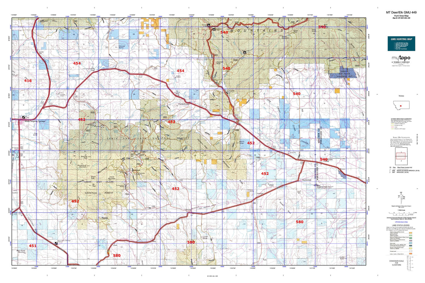
Hunting unit map of Montana Game Management Unit DEL-449 with topographic lines and unit boundaries. This topo map features UTM / MGRS and Latitude/Longitude grids, plus public land ownership. It comes folded on waterproof paper. Be fully prepared for your hunt with a MyTopo GMU map!.
This map contains the following named places: 59053,Agate Creek,Alabaugh Creek,Alkali Creek,Bair Dam,Bair Reservoir,Bair Reservoir Sportsmans Access,Bair Spring,Basin Creek,Basin Creek Campground,Baxter Gulch,BCE Number 3959 Mine,Beartrap Peak,Belle of the Castle Mine,Big Coulee,Blackhawk,Blackhawk Cabin,Bonanza,Bonanza Creek,Bonanza Dam,Bonanza Ranch,Bonanza Reservoir,Bond Holder Mine,Boulder Creek,Bozeman Fork Musselshell River,Broadway Mine,Brock Ranch,Brooks Creek,Bruno,Butler Hill,California Mine,Cameron Creek,Casey Creek,Castle Cemetery,Castle Creek,Castle Lake,Castle Mountain,Castle Mountains,Castle Town,Checkerboard,Checkerboard Creek,Christensen Number 1 Dam,Christensen Number 2 Dam,Christensen Reservoir,Clara Burton Mine,Clay Butte,Coates Pond,Comb Butte,Comb Creek,Compromise Mine,Cooks Flat,Cooks Gulch,Cooper Creek,Copper,Copper Creek,Copperopolis,Copperopolis Mine,Cornelius Stone Placer Mine,Corral Creek,Cottonwood Creek,Coyote Creek,Cumberland Mine,Cumberland Mines,Cut Bank Mine,Daisy Narrows,Deer Creek,Dry Fork,Dry Fork Musselshell River,East Fork Checkerboard Creek,East Fork Cottonwood Creek,East Fork Grasshopper Creek,East Fork Spring Creek,Eightmile Creek,Elephant Rock,Elk Peak,Fifty Dollar Bill Dam,Findon,Fivemile Creek,Flagstaff Creek,Flagstaff Enclosure,Flagstaff Reservoir,Fort Howie,Fourmile Creek,Fourmile Spring,Freemans,Gillis Creek,Golden Eagle Mine,Gordon Butte,Grande Dam,Grasshopper Campground,Grasshopper Creek,Great Western Mine,Green Canyon,Groveland,Hall Creek,Hall Creek Spring,Hamilton Creek,Hamilton Mine,Harris Spring,Hensley Creek,Hereim Creek,Hidden Treasure Mine,Hillside Mine,Holliday Dam,Holliday Landing Strip,Homestake Mine,Horse Park,Hundred Dollar Bill Dam,Ice Creek,Iron Chief Mine,Johnson Park,Judge Mine,Jumbo Mine,Kents Gulch,Lake Creek,Lake Sutherlin,Lake Sutherlin Recreation Site,Lamar Mine,Leadboro,Leadboro Junction,Legal Tender Mine,Lennep,Lennup Cemetery,Limestone Ridge,Lion Creek,Little Cottonwood Creek,Long Canyon,Lost Horse Creek,Lou Ire Mine,Loweth,Lucky Boy Mine,Lucky Dollar Mine,Manger Dam,Manger Park,Martinsdale,Martinsdale Census Designated Place,Martinsdale-Ringling Division,Meadow Creek,Mill Creek,Mill Ditch,Miller Spring,Moonlight Mine,Morning Star Mine,Moss Agate,Mount Howe,Mud Creek,Muddy Creek,NE NE Section 11 Mine,NE NE Section 36 Mine,New Deal Mine,North Fork Bonanza Creek,North Fork Eightmile Creek,North Fork of Smith River Dam,North Fork Whetstone Creek,NW NE Section 15 Mine,NW NW Section 19 Mine,NW NW Section 27 Mine,NW SE Section 11 Mine,NW SE Section 23 Mine,Orcutt Gulch,Oscar Olson Dam,P K Spring,Pasture Gulch,Picnic Canyon,Pig Creek,Pinchout Creek,Quaking Aspen Coulee,Rattler Creek,Reese Creek,Reynolds Creek,Richardson Campground,Richardson Creek,Richardson Park,Ringling Mine,Robinson,Robinson Creek,Saint Charles,Sawmill Creek,SE NE Section 11 Mine,SE SE Section 11 Mine,SE SE Section 22 Mine,SE SW Section 2 Mine,SE SW Section 34 Mine,Seventyone Ranch,Silver Star Mine,Slaughter House Creek,Smith Fork,Solbergs Pine Valley Cabins,Solid Silver Mine,Sourdough Creek,South Fork Bonanza Creek,South Fork Eightmile Creek,South Fork Whetstone Creek,South Fork Willow Creek,South Side Canal,Spring Creek,Spring Creek Campground,Stohr Creek,SW NE Section 2 Mine,SW NW Section 15 Mine,SW SW Section 2 Mine,SW SW Section 27 Mine,SW SW Section 29 Mine,SW SW Section 30 Mine,SW SW Section 35 Mine,SW SW Section 36 Mine,The Reefs,Thomas Creek,Thorsens Pond,Townsend Gulch,Trail Creek,Trinity Spring,Trout Creek,Voldseth East Dam,Voldseth Ranch,Voldseth Reservoir,Voldseth West Dam,Wapiti Peak,Warm Springs Creek,Waterloo Mine,West Fork Checkerboard Creek,West Fork Cooper Creek,West Fork Cottonwood Creek,West Fork Flagstaff Creek,West Fork Mud Creek,Whetstone Creek,Whetstone Ridge,Whitetail Creek,Willow Creek,Willow Creek Reservoir,Willow Peak,Woodchuck Mountain,Woods Gulch,Yankee Jim Ridge,Yellowstone Mine