MyTopo
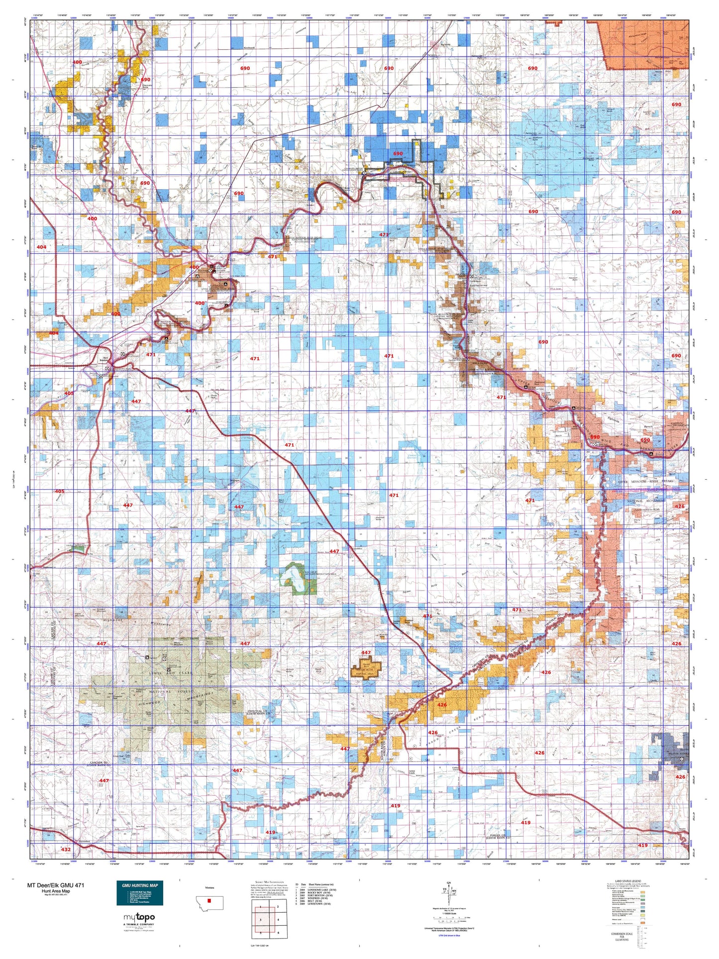
Montana Deer/Elk GMU 471 Map
Couldn't load pickup availability
Hunting unit map of Montana Game Management Unit DEL-471 with topographic lines and unit boundaries. This topo map features UTM / MGRS and Latitude/Longitude grids, plus public land ownership. It comes folded on waterproof paper. Be fully prepared for your hunt with a MyTopo GMU map!.
This map contains the following named places: 59424,59442,59446,59460,59520,Alder Creek,Antelope Butte,Archers Island,Arrow Creek,Arrow Peak,Baker Bar,Beaver Creek,Benton RV Park,Bessette Ranch,Big Lake,Big Sag Creek,Big Sandy,Big Sandy Division,Big Sandy Trailer Court,Birch Creek,Bishop Creek,Black Buttes,Black Rock,Boggs Island,Boyd Creek,Braun Creek,Briggs Creek,Brule Bar,Buckskin Butte,Butte Creek,Cairo,Carl O'Hara Ranch,Carter Mountain,Centennial Mills Incorporated Elevator,Central Montana Cooperative Elevator,Chappell,Chimney Creek,Chimney Rock,Chip Creek,Chouteau County,Chouteau County Fairgrounds,Chouteau County Waterfowl Production Area,Churchill Butte,City of Fort Benton,Clark Creek,Clear Lake,Coal Banks Landing,Coalbanks Campground,Coalbanks Recreation Area,Coffee Creek,Colony Bay,Corral Creek,Cottonwood Creek,Cowboy Creek,Crow Coulee Bar,D and S RV Park,Dammel Reservoir,Dark Butte,Davis Creek,Deer Creek,Denton,Denton City Park,Denton Division,Dexter Creek,Discovery Butte,Dog Creek,Dry Fork,Eagle Buttes,Eagle Creek,Eagle Creek Fishing Access Site,East Ophir,East Peak,Erwin Creek,Evans Bend,Fall Creek,Farmers Cooperative Elevator,Flanagan Creek,Flat Creek,Flying A Butte,Fort Benton,Fort Benton City Park Rest Area,Fort Benton Historical Marker,Fort Brule,Fort Campbell,Fort LaBarge,Fort Piegan,Fortress Rock,Freiling Ranch,Frenchman Creek,Gallatin Valley Milling Company Elevator,General Mills Incorporated Elevator,Geraldine,Geraldine Division,Gerard Creek,Godfrey Creek,Goin Creek,Grant Creek,H Earl Clack Elevator,Harris Creek,Harwood Lake,Harwood Stage Station,Hawarden Hall,Haystack Butte,Highwood Baldy,Highwood Cow Camp,Highwood Guard Station,Hole in the Wall Trail,Hop Creek,Hopp,Inga,In-moolsh Creek,International Elevator,Keaster Creek,Kelley Creek,Kenilworth,Kingsbury Lake,Kirby Creek,Lacey Creek,Lava Peak,Lepley,Lepleys Creek,Lewis and Clark State Memorial,Libby Hills,Lions Club Park,Lippard,Liscum,Little Battle Creek,Little Eagle Creek,Little Sandy Creek,Loma,Loma Bridge Fishing Access Site,Lonetree,Lost Lake,Mansfield Creek,Marias,Marias River,Marias River Historical Marker,Martin Creek,McMurtry Creek,McNamara and Marlow Elevator,McNamara Butte,Merrill Creek,Middle Fork Little Belt Creek,Middle Peak,Montague,Montana Crossroads Historical Marker,Montana Elevator,Mount Hancock,Mount Kennon,Muddy Creek,North Fork Highwood Creek,North Fork Little Belt Creek,North Gap Creek,North Ophir,North Peak,O'Hara Brothers Ranch,Ophir,Pablo Island,Palisade Butte,Panton Coulee Reservoir,Patterson,Peavey Company Grain Elevator,Peel Creek,Pine Creek,Pinewood Peak,Pleasant Valley,Pohlod Creek,Possum Run Creek,Postill Creek,Pownal,Prospect Peak,Rat Creek,Rattlesnake Butte,Rocky Lake,Rocky Mountain Elevator,Roosevelt Island,Rose Creek,Round Butte,Round Top,Ryan Butte,Saint Anthony and Dakota Elevator,Sand Lake,Scottish Creek,Seifort Reservoir,Shaws Peak,Shea Creek,Shed Creek,Shep Memorial,Shonkin,Shonkin Bar,Shonkin Cow Camp,Shonkin Creek,Shonkin Lake,Shoulder Creek,Signal Point Golf Club,Skillion Creek,Skunk Creek,Smith Creek,South Fork Little Belt Creek,South Peak,Spring Creek,Square Butte,Steamboat Rock,Stevenson Ranch,Stoner Creek,Stranahan,Streit Ranch,Studhorse Butte,Surprise Creek,Teton River,Teton Station,Thain Creek,Thain Creek Campground,The Badlands,Three Islands,Timber Creek,Tolan Creek,Town of Big Sandy,Town of Denton,Town of Geraldine,Verona,Virgelle,Warren Creek,Watkins Creek,Waymeir Creek,West Fork Flat Creek,Western Lumber and Grain Company Elevator,White Lake,White Rocks,Whoop-Up Trail Monument,Wild Horse Butte,Willow Creek,Windy Mountain,Wolf Island,World War I Memorial