MyTopo
Montana Deer/Elk GMU 530 Map
Couldn't load pickup availability
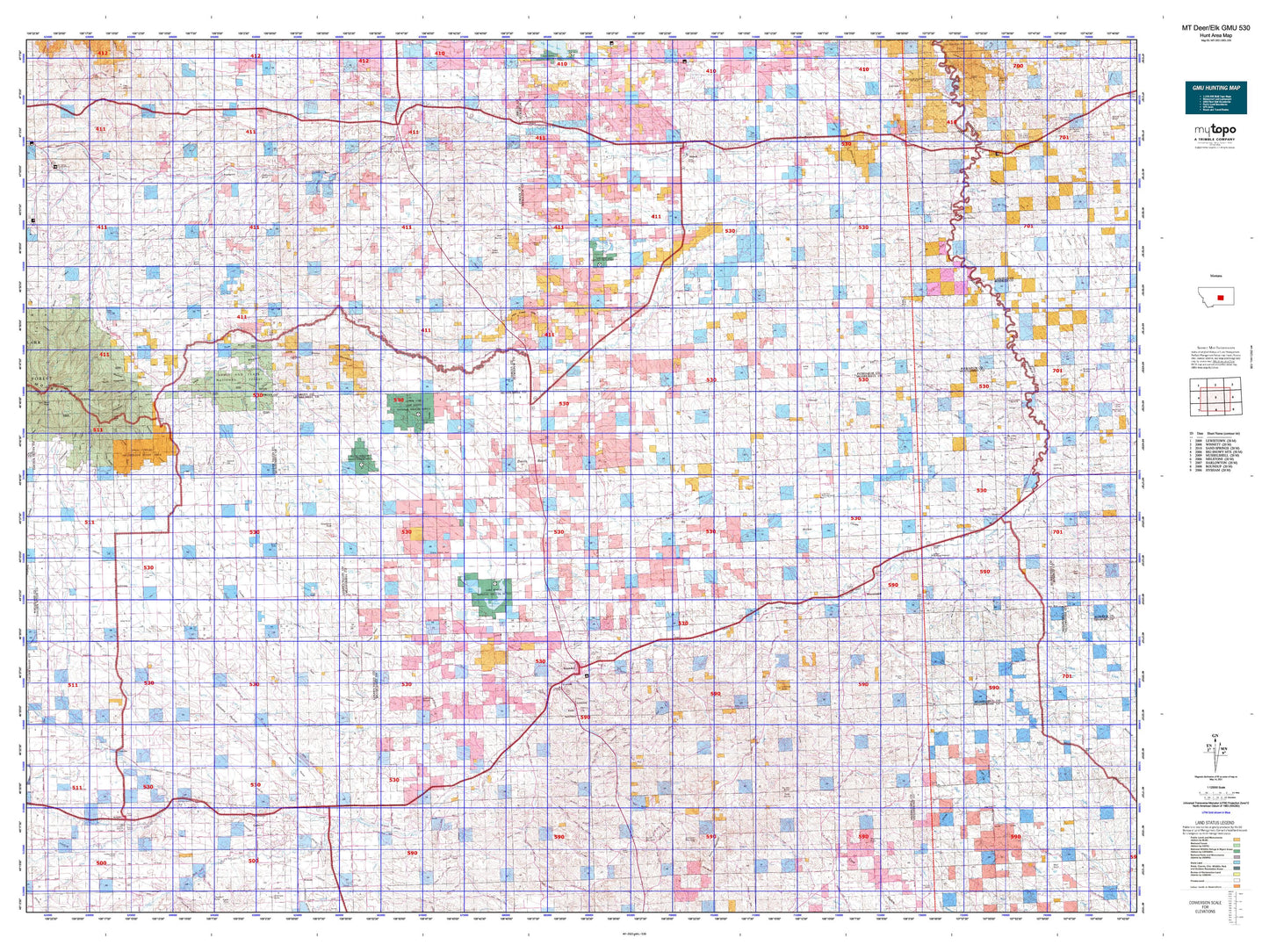
Hunting unit map of Montana Game Management Unit DEL-530 with topographic lines and unit boundaries. This topo map features UTM / MGRS and Latitude/Longitude grids, plus public land ownership. It comes folded on waterproof paper. Be fully prepared for your hunt with a MyTopo GMU map!.
This map contains the following named places: 59032,59046,59059,59072,59441,Absher,Akers Ranch,Alaska Bench,Alkali Creek,Athern Creek,Ayers Ranch Colony,Bald Butte,Battrick,Bear Creek,Beaver Ball Creek,Becket,Belmont,Bender Creek,Big Coulee Creek,Blacktail Creek,Blue Streak Downs,Box Elder Creek,Brodie,Brush Creek,Buck Creek,Buffalo Creek,Bullhead Creek,Bundy,Burgoyne Siding,Busse Water,Button Butte,Cameron Creek,Camp Three,Careless Creek,Carpenter Creek,Cat Creek,Chamberlain,Chandler Ditch,Chimney Butte,City of Roundup,Cooley Goffena Ditch,Cow Country Historical Marker,Crooked Creek,Currant Creek,Cushman,Darrel,Davisten,Dean Creek,Delphia,Des Moines Lakes,Devils Basin,Devils Hole Lake,Dry Creek,Dry Fork,Dry Fork Hawk Creek,Dry Lake,Dryland,Duncan Creek,Dunn Mountain,Durfee Creek,East Fork Carpenter Creek,East Fork Dean Creek,East Parrot Creek,Egge Ditch,Elbow Hill,Elk Creek,Elso,Emory,Farmers Elevator,Farmers Union Elevator,Farralltown,Fattig,Fattig Creek,Fish Creek,Fishel Creek,Fivemile Creek,Flatwillow,Flatwillow Colony,Flatwillow Creek,Forestgrove,Fourmile Creek,Franklin,Fratt,Gage,George Ore Memorial Park,Gibbtown,Glennie Ditch,Golden Valley County,Goulding Creek,Grass Range,Grass Range City Park,Grass Range Division,Guffena Sudan Ditch,Gyp Basin,Half Moon Creek,Halfbreed Creek,Hawk Creek,Heath,Holt Creek,Horsethief Creek,Howard Creek,Hoyle,Jackman,Jim Bartlett Field,Jitney,Johnston Mountain,Jones Creek,Kelley,Kilby Butte,Kilby Butte Colony,Klein,Klein Division,Krueger Spendiff Ditch,Lake Mason,Lake Mason National Wildlife Refuge,Lake Thom,Lamberts Bench,Lavina,Lavina City Park,Lavina Division,Lavina Water Users Association Ditch,Little Montana Truckstop Campground,Little Wall Creek,Little Wall Pumping Station,Lost Peak,Lucky Fort,Lyons Butte,Maginnis Creek,Maxwell Ranch,May Martin Lake,Maynard Creek,McCartney Creek,McDonald Butte,McDonald Creek,McLean Elevator,McLean Lake,Melstone Division,Merrills Springs Creek,Middle Bench,Miller Lake,Minerva Creek,Montana and Dakota Elevator,Montana Elevator,Moss Ranch,Mud Springs Creek,Musselshell,Musselshell County,Musselshell County Fairground,Musselshell Ditch County Canal,N Bar Ranch,Naderman Buttes,Naderman Ditch,N-F Ditch,Ninemile Creek,North Fork Elk Creek,North Fork Flatwillow Creek,North Fork McDonald Creek,North Fork Pole Creek,North Fork Yellow Water Creek,North Maginnis Creek,North Willow Creek,Orange,Painted Robe Creek,Parrot Creek,Petrolia Lake,Pike Creek,Pinchgut Stage Station,Pine Ridge,Pine Ridge Golf Club,Pine View,Piper,Pole Creek,Potter Creek,Queens Point,Rattlesnake Butte,Ray Creek,Red Hill,Rehder Creek,Republic,Riverside,Rock Springs,Rocky Mountain Elevator,Rothiemay,Roundup,Roundup City Park,Roundup Division,Ryegate,Ryegate City Park,Sahara,Sahara Hill,Sand Creek,Schaffs RV Court,Schumachers,Shovel Creek,Signal Mountain,Slayton,Slayton Junction,Snoose Creek,South Bench,South Fork Flatwillow Creek,South Fork McDonald Creek,South Fork Pole Creek,Spring Creek,Square Butte,Stanley Creek,Steamboat Butte,Steamboat Rock,Surenough Creek,Talbot Lake,Teigen,Three Buttes,Timber Buttes,Town of Grass Range,Town of Lavina,Town of Ryegate,Town of Winnett,Tyler,Tyler Creek,Vebar,Wallview,War Horse National Wildlife Refuge,Warr,Weede,West Fork Tyler Creek,West Parrot Creek,West Roundup,Wheaton,Whoop-Up Creek,Willow Creek,Winnett,Winnett Irrigation County Ditch,Winnett South Division,Womans Pocket,Yellow Water Creek,Yellow Water Reservoir