MyTopo
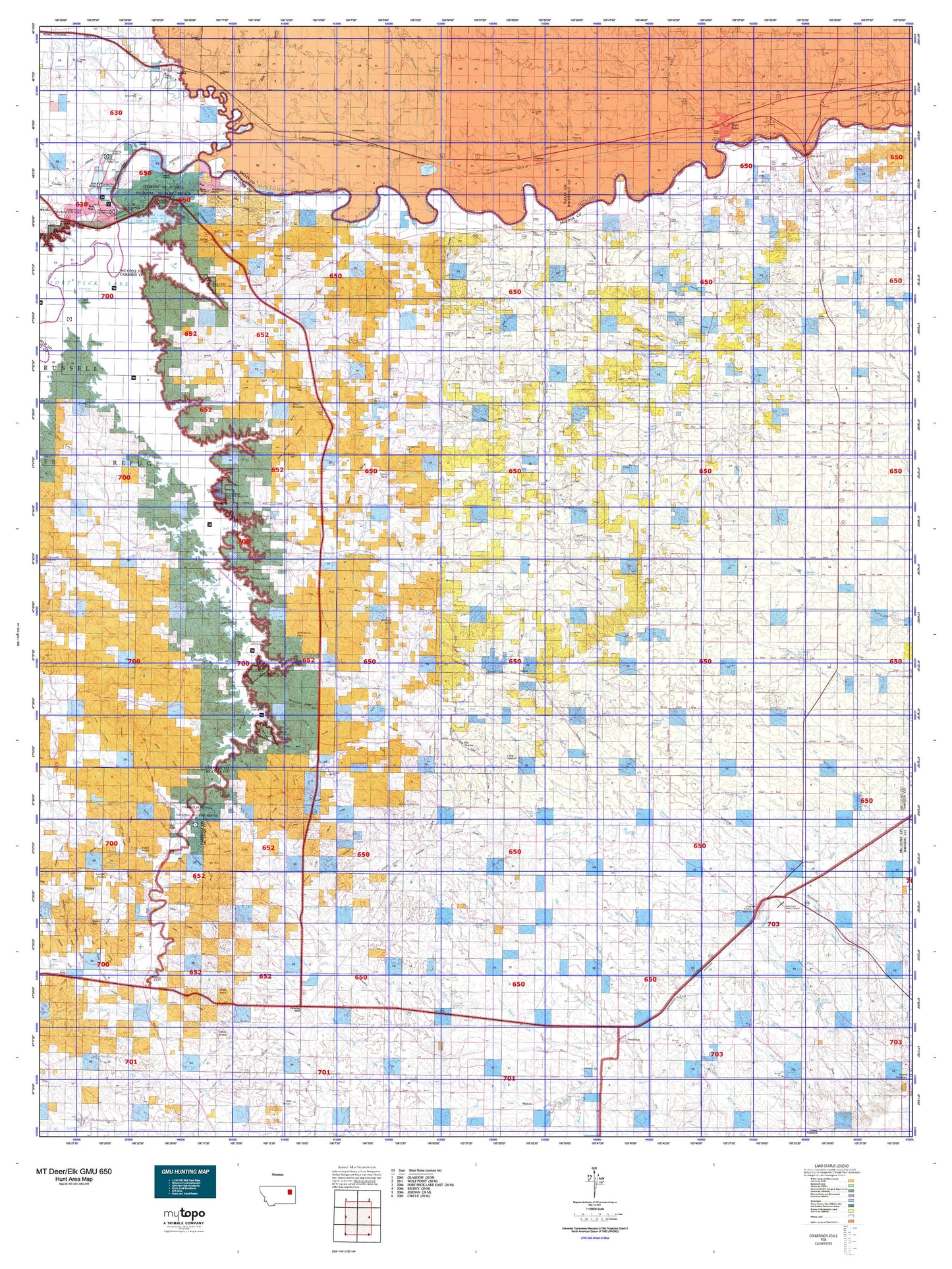
Montana Deer/Elk GMU 650 Map
Couldn't load pickup availability
Hunting unit map of Montana Game Management Unit DEL-650 with topographic lines and unit boundaries. This topo map features UTM / MGRS and Latitude/Longitude grids, plus public land ownership. It comes folded on waterproof paper. Be fully prepared for your hunt with a MyTopo GMU map!.
This map contains the following named places: Airport Golf Club,Anderson Creek,Andrews Hill,Antelope Creek,Antelope Creek Reservoir,Ash Creek,Bald Butte,Bear Creek,Bear Creek Recreation Area,Beauty Creek,Ben Larson Park,Big Butte,Big Dry Creek,Big Heaven,Big Mud Creek,Big Wild Horse Creek,Bobcat Creek,Bonhoff Butte,Borge Park,Box Elder Creek,Bridge Park Fishing Access Site,Brockway,Browns Coulee Reservoir,Buffalo Springs Creek,Bug Creek,Camp Creek,Caprock Butte,Cat Creek,Cedar Bed Ground Reservoir,Charley Creek,Cheer Creek,Christianson Reservoir,Circle,Circle Division,Circle Historical Marker,Circle Park,Circle Trailer Court,City of Wolf Point,Coal Creek,Coal Hill,Cobb Hill,Corner Butte,Cotter Creek,Crow Creek,Daniels Point,Dawson Creek,Deadman Butte,Denwoody Creek,Devils Table Rock,Dinosaurs Historical Marker,Dirty Creek,Dreyer Reservoir,Dry Ash Creek,Dubbe Reservoir,East Fork Charley Creek,East Fork Flynn Creek,East Fork Oswego Creek,East Fork Prairie Elk Creek,East Fork Sand Creek,Equity Co-op Association Elevator,Equity Cooperative Elevator,Farmers Elevator,Farmers Produce Company Elevator,Farmers Union Elevator,Figure Eight Creek,Firehall Park,Flat Creek,Flat Lake Recreation Area,Flint Ranch,Flowing Well,Flowing Wells Rest Area,Flying V Creek,Flynn Creek,Fort Copeland,Fort Dauphin,Fort Peck,Four Corners,Frazer,Frazer Lake,Frazer Pumping Station,Friend Siding,Game Reservoir,Gass Reservoir,General Mills Incorporated Elevator,Goat Mountain,Good Creek,Goose Island Reservoir,Groh Stock Reservoir,Gyp Creek,Hamblin,Harvest States Cooperatives Elevator,Haynie Reservoir,Hell Creek,Hell Gate Reservoir,Hook Rock,Horse Creek,Hudiburgh Reservoir,Hungry Creek,Imperial Elevator,In Memoriam Historical Marker,Indian Hill,Indian Rocks,Inperial Elevator,Jack Creek,Jacks Point,Jays Reservoir,Jefferson Point,Joe Creek,John Ball Reservoir,Kintyre,Kintyre Creek,Lambetts,Leaky Reservoir,Lenox,Lewis and Clark Park,Lions Park,Little Dry Creek,Little Heaven,Little Mud Creek,Little Porcupine Creek,Little Wild Horse Creek,Little Wolf Creek,Littleman Creek,Lohmiller,Lone Tree Creek,Long Branch Creek,Lost Creek,Lucky Hill,Lytle Hill,Macon,Maxwell Hill,McCone County,McCone County Fairgrounds,McCune Creek,McDonald Butte,McGuire Creek,McGuire Creek Recreation Area,Middle Fork Prairie Elk Creek,Middle Fork Remuda Creek,Middle Fork Sand Creek,Middle Fork South Fork Rock Creek,Milk River,Moes Trailer Court,Nashua,Nellies Park,Nelson Creek,Nelson Creek Recreation Area,North Fork Box Creek,North Fork McGuire Creek,North Fork Rock Creek,North McCone Division,North Prong Coal Creek,North Prong Shade Creek,North Twitchell Point,Norville Creek,Occident Elevator,O'Dell Coulee Reservoir,Oswego,Oswego Creek,Oswego Elevator,Paris,Pasture Creek,Pearmond,Peavey Company Elevator,Peavey Elevator,Pleasant Valley,Pleasant Valley Community Hall,Porcupine Creek,Porcupine Creek Overflow,Prairie Elk,Prairie Elk Colony,Prairie Elk Creek,Quick Reservoir,Rancho Campground and Motel,Remuda Creek,Rock Creek,Rock Creek Fishing Access Site,Rock Creek State Park,Rocky Butte,Rodgers Hall,Rough Prong McGuire Creek,Sand Arroyo Badlands,Sand Creek,Scheers Trailer Court,Shade Creek,Sherman Park,Short Creek,Skull Creek,Smith-Tyner Elevator,Snap Creek,South Fork Box Creek,South Fork Rock Creek,South Fork Shade Creek,South Twitchell Point,Spring Creek,Stampede Grounds,Standing Rock,Stephensons Trailer Court,Stole Creek,Stony Butte Creek,Stony Butte Hill,Stubby Point,Sundown Drive-In,Teds Reservoir,Teton Butte,Thorpe Elevator,Three Buttes,Timber Creek,Town of Circle,Town of Nashua,Triangle Park,Turtle Creek,Tusler Creek,Tveten Reservoir,Twitchell Ranch,Upper O'Dell Coulee Reservoir,Van Norman,Vanderhoof Hill,Warren Memorial Park,Weldon,West Fork Charley Creek,West Fork Hungry Creek,West Fork Lost Creek,West Fork Remuda Creek,West Fork Sand Creek,Westland Hill,White,White Buttes,Willis Buttes,Winter Truesdell Elevator,Wiota,Wolf Creek,Wolf Point,Wolf Point Historical Marker,Woody Creek