MyTopo
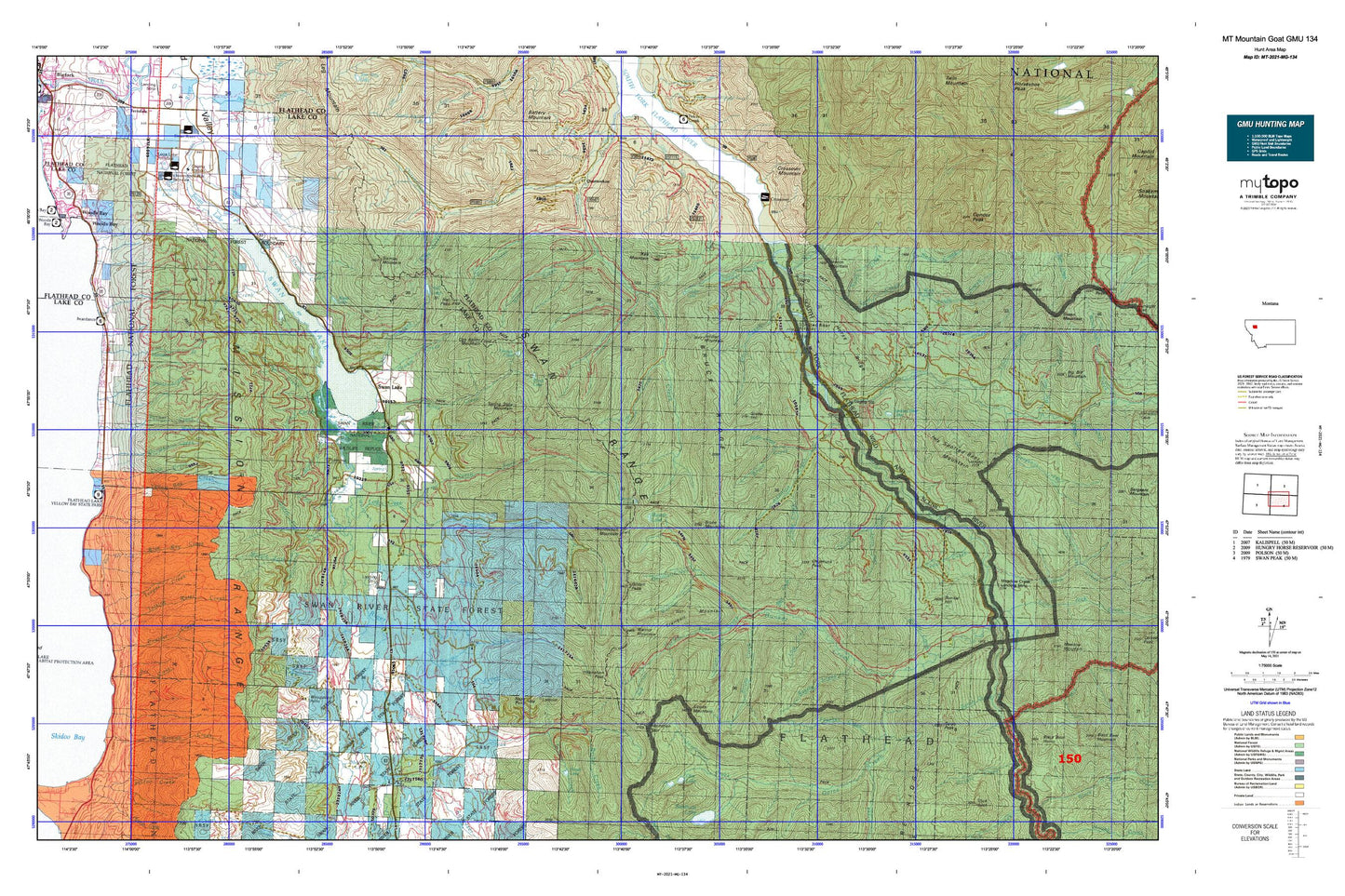
Montana Mountain Goat GMU 134 Map
Couldn't load pickup availability
Hunting unit map of Montana Game Management Unit MG-134 with topographic lines and unit boundaries. This topo map features UTM / MGRS and Latitude/Longitude grids, plus public land ownership. It comes folded on waterproof paper. Be fully prepared for your hunt with a MyTopo GMU map!.
This map contains the following named places: 23N17W18DBDD01 Well,24N17W07BCAA01 Well,25N18W13CDDC01 Well,25N18W14DBB_01 Well,25N18W35ADDA01 Well,25N18W35DBCB01 Well,26N19W11BBDD01 Well,Addition Creek,Alcove Creek,Alcove Lake,Alcove Mountain,Ball Creek,Beacon Mountain,Bear Creek,Bear Dance Census Designated Place,Bent Creek,Bethal Creek,Billy R Garrett Memorial Bridge,Blue Bay,Blue Bay Creek,Bond Creek,Bond Lake,Boulder Creek,Branch Creek,Bruce Creek,Bruce Meadows,Bruce Mountain,Bruce Ridge,Bug Creek,Bunker Hill,Bunker Lake,Bunker Park,Chipmunk Peak,Cilly Creek,Cinabar Mountain,Cliff Creek,Con Kelley Mountain,Connor Creek,Crevice Lake,Crossover Campground,Crossover Mountain,Deadfall Creek,Dee Creek,Deer Lick Resort,Dry Park Creek,Elam Creek,Feather Creek,Flat Creek,Flathead National Forest,Foothill Meadows,Gildart,Gildart Creek,Gildart Lakes,Gildart Peak,Gorge Creek,Graves Meadows,Groom Creek,Hall Creek,Hall Lake,Hall Peak,Horse Ridge,Horseshoe Lake,Horseshoe Lake - Ferndale Fishing Access Site,How Creek,In-pa-ah Creek,Inspiration Creek,Inspiration Lakes,Inspiration Pass,Inspiration Point,Johnson Creek,Jungle Creek,Kah Lookout,Kah Mountain,Larch Creek,Late Creek,Late Lake,Lime Creek,Little Creek,Little Napa Lookout,Loon Lake,Loon Lake Access,Lost Creek,Lower Twin Creek,Metcalf Lake,Middle Fork Creek,Middle Fork Porcupine Creek,Mission Lookout,Mission Well,Montana State Highway 83 Weigh Staton,Mount Orvis Evans,Nanny Creek,Napa Creek,Napa Point,North Creek,North Fork Connor Creek,North Fork Lost Creek,North Fork Porcupine Creek,No-see-em Creek,Olor Lake,Parker Creek,Perry Creek,Picture Lake,Point Pleasant Campground,Porcupine Creek,Posy Creek,Quintokon Forest Service Station,Quintonkon,Quintonkon Creek,Razzle Creek,Red Creek,Red Owl Creek,Rock Creek,Rock Lake,Sarah Peak,Schmidt Creek,Scout Creek,Scout Lake,Sixmile Creek,Sixmile Mountain,Slide Creek,Soldier Creek,Soldier Lake,Soldier Mountain,Soup Creek,Soup Creek Campground,South Creek,South Fork Branch Creek,South Fork Division,South Fork Dry Park Creek,South Fork Lost Creek,South Fork River Access,South Woodward Creek,Spotted Bear Campground,Spotted Bear Lake,Spotted Bear Mountain Trail,Spotted Bear Ranger Station,Spotted Bear River,Spotted Bear/USFS Airport,Spring Creek,Spring Slide Mountain,Squeezer Creek,Stadium Creek,State Meadows,Station Creek,Stony Creek,Stony Hill,Stopher Creek,String Creek,Swan Chapel,Swan Lake,Swan Lake Campground,Swan Lake Census Designated Place,Swan Lake Guard Station,Swan Lake Picnic Site,Swan Lake Post Office,Swan Lake Public Library,Swan Lake School,Swan Lake Volunteer Fire Department,Swan River Correctional Training Center,Swan River National Wildlife Refuge,Swan River State Forest,Swan River State Forest Headquarters,Swan Village Market and Campground,Swift Creek,Talking Water Creek,Tanner Creek,Taylor Creek,Teepee Creek,Thunderbolt Mountain,Tin Creek,Tranquil Mountain,Trinkus Lake,Twin Creek,Warrior Creek,Warrior Mountain,Webb Lake,Weed Lake,Whitetail Creek,Wickiup Mountain,Willow Creek,Wire Trail,Woods Bay-Rollins Division,Woodward Creek,Woodward Point,Wyman Creek,Yew Creek