MyTopo
Montana Mountain Goat GMU 150 Map
Couldn't load pickup availability
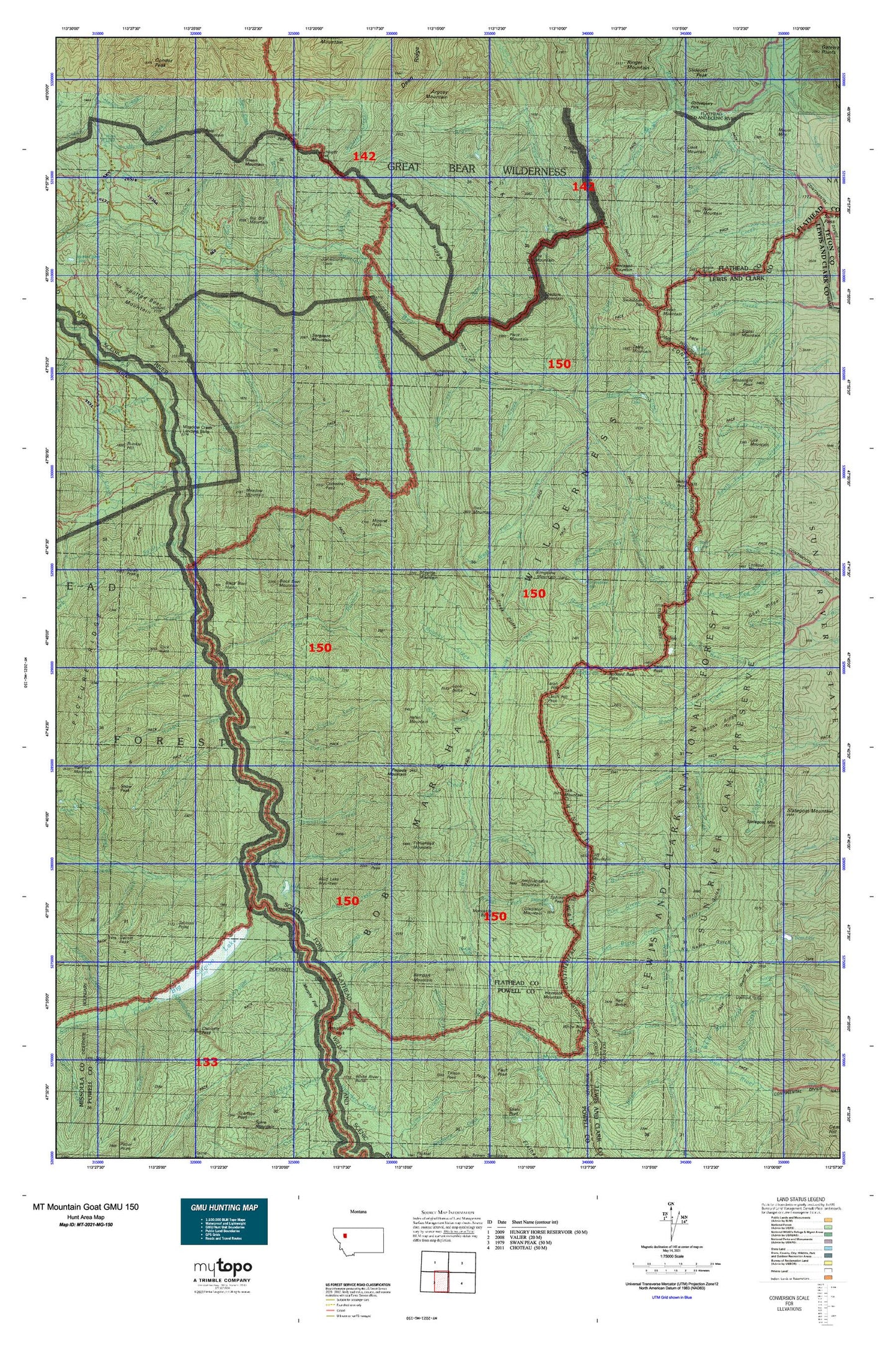
Hunting unit map of Montana Game Management Unit MG-150 with topographic lines and unit boundaries. This topo map features UTM / MGRS and Latitude/Longitude grids, plus public land ownership. It comes folded on waterproof paper. Be fully prepared for your hunt with a MyTopo GMU map!.
This map contains the following named places: 59919,Ahorn Creek,Amphitheatre Mountain,Angle Point,Argosy Creek,Argosy Mountain,Beaver Creek,Beaver Creek Campground,Beaver Hill,Bent Mountain,Big Bill Creek,Big Bill Mountain,Big Salmon Creek,Big Salmon Lake,Black Bear Creek,Black Bear Forest Service,Black Bear Guard Station,Black Bear Hump,Black Bear Mountain,Blue Lakes,Bob Marshall Wilderness,Bow Mountain,Bowl Creek,Brushy Park,Bungalow Lookout Trail,Bungalow Mountain,Bunker Creek,Burnt Creek,Cathedral Peak,Chair Mountain Trail,Charlotte Creek,Charlotte Peak,Chinese Wall,Chinese Wall Trail,Christopher Creek,Christopher Lake,Clack Creek,Clack Mountain,Cliff Creek,Cliff Mountain,Cone Peak,Corporal Creek,Cruiser Mountain,Damnation Creek,Dean Creek,Dean Creek Campsite,Dean Falls,Dean Lake,Dean Ridge,Deer Creek,Diamond Lake,East Fork Pentagon Creek,Elk Ridge,Gladiator Mountain,Goat Creek,Gooseberry Park,Green Mountain,Green Mountain Trail,Grizzly Gulch,Gunsight Lake,Gunsight Peak,Gunsight Rock,Gunsight Trail,Hahn Peak,Harrison Creek,Hart Creek,Hart Lake,Haystack Mountain,Haystack Mountain Trail,Helen Creek,Helen Creek Trail,Helen Mountain,Henry Anderson Creek,Hermit Lake,Hodag Creek,Holbrook Creek,Holbrook Guard Station,Hoop Creek,Hungry Creek,Ibex Mountain,Independence Park,Indian Creek,Indian Point Guard Station,Juliet Creek,Kevan Mountain,Lake Levale,Lamoose Creek,Larch Hill,Larch Hill Pass,Larch Hill Trail,Lewis Creek,Lime Creek,Limestone Peak,Limestone Wall,Little Salmon Creek,Little Salmon Park,Lone Butte,Lost Jack Creek,Meadow Creek,Meadow Creek Gorge,Meadow Creek Guard Station,Meadow Creek Recreaton Site,Meadow Creek USFS Airport,Meadow Mountain,Mid Creek,Mid Mountain,Milk Creek,Minaret Peak,Moccasin Butte,Moose Ridge,Mud Lake,Mud Lake Mountain,Murphy Flat,My Lake,Needle Falls,No Name Gulch,North Fork Helen Creek,Oasis Pond,Pagoda Creek,Pagoda Mountain,Pagoda Mountain Lookout,Park Creek,Pedro Creek,Peggy Creek,Pentagon Clack Creek Trail,Pentagon Creek,Pentagon Guard Station,Pentagon Mountain,Phil Creek,Picture Creek,Pine Creek,Pivot Mountain,Pot Lake,Pot Mountain,Pot Mountain Lookout,Rambler Creek,Rampart Mountain,Red Butte,Red Butte Creek,Redhead Peak,Rock Creek Guard Station,Rock Creek Trail,Rooney Creek,Salmon Forks Guard Station,Salmon Point,Salt Mountain,Sarah Creek,Scalp Creek,Seep Creek,Sergeant Creek,Sergeant Mountain,Shadow Lake,Shadow Mountain,Shelf Lake,Signal Mountain,Silvertip Creek,Silvertip Guard Station,Silvertip Mountain,Slick Creek,Slick Rock,Slim Creek,Snow Creek,Sock Lake,Solitude Point,South Fork White River,Sphinx Peak,Spotted Bear Pass,Spotted Bear River Trail,Spotted Bear Schafer Trail,Spring Lake,Spy Mountain Trail,Straight Creek,Strawberry Creek,Switchback Pass,Table Hill,Table Mountain,Three Lakes Creek,Three Sisters,Three Sisters Creek,Trilobite Lakes,Trilobite Peak,Trilobite Range,Turtlehead Mountain,Unnamed Lake,Wall Creek Cliffs,West Fork Schafer Creek,West Fork Wall Creek,Whitcomb Creek,Whitcomb Peak,White Bear Creek,White River,White River Park,White River Pass,White River Trail,Woodfir Creek