MyTopo
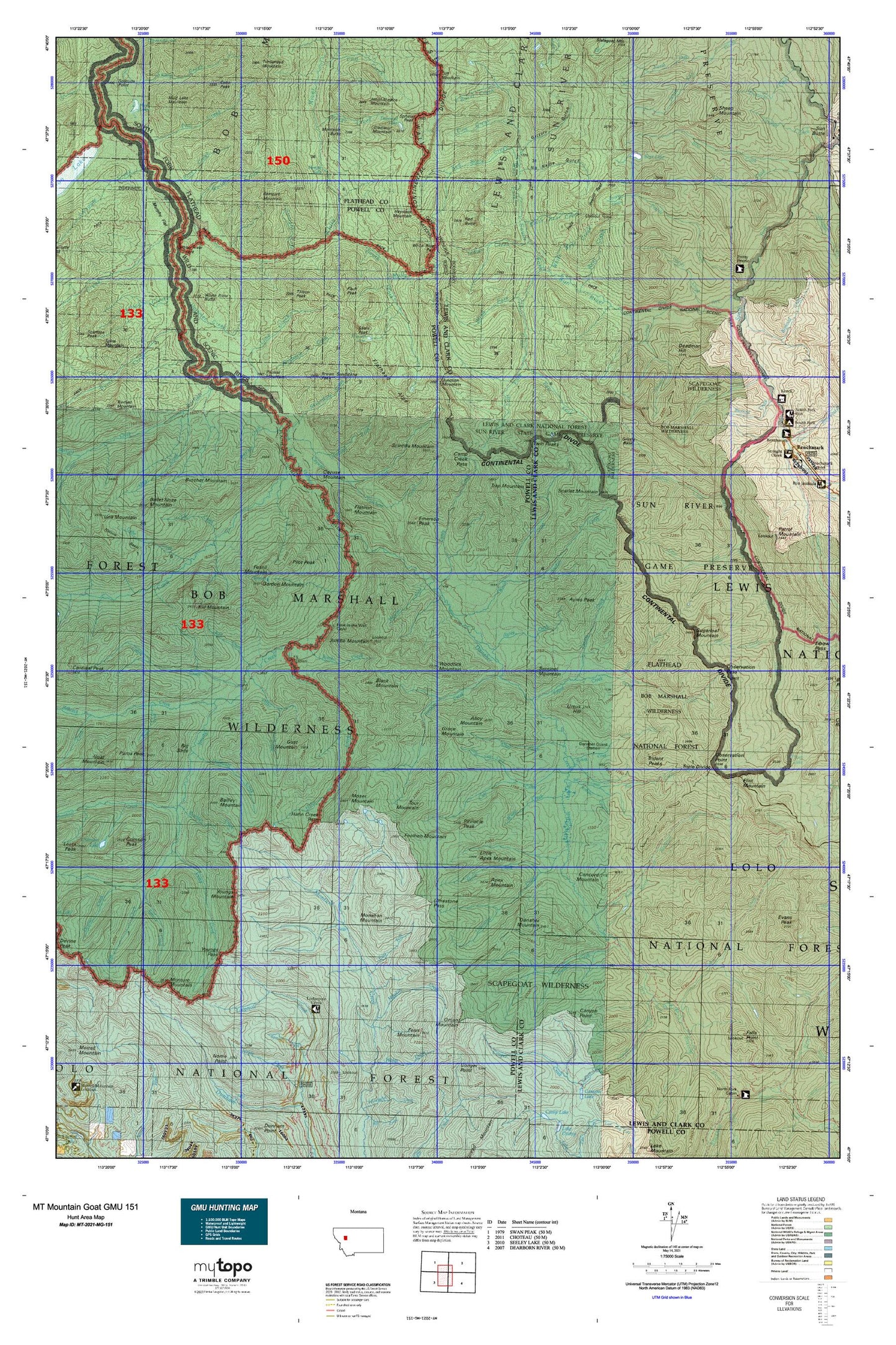
Montana Mountain Goat GMU 151 Map
Couldn't load pickup availability
Hunting unit map of Montana Game Management Unit MG-151 with topographic lines and unit boundaries. This topo map features UTM / MGRS and Latitude/Longitude grids, plus public land ownership. It comes folded on waterproof paper. Be fully prepared for your hunt with a MyTopo GMU map!.
This map contains the following named places: Ahorn Basin,Ahorn Creek,Ahorn Creek Trail,Alloy Creek,Alloy Mountain,Amphitheatre Mountain,Antoine Creek,Apex Mountain,Ayres Creek,Ayres Peak,Babcock Creek,Bar Creek,Bartlett Creek,Basin Creek,Basin Creek Guard Station,Bear Lake,Bear Park,Big Prairie,Big Prairie Work Center,Big Slide,Bighead Creek,Black Bear Creek,Black Mountain,Blind Fork,Boulder Creek,Brown Sandstone Peak,Brownstone Creek,Burnt Cabin,Burnt Cabin Creek,Burnt Creek,Butcher Creek,Butcher Mountain,Cabin Creek,Calf Creek,Camp Allan,Camp Creek,Camp Creek Pass,Camp Creek Pass Trail,Canyon Creek,Canyon Point,Catchem Creek,Catchem Creek Trail,Cayuse Creek,Cayuse Mountain,Center Creek,Center Creek Trail,Chinese Wall,Chinese Wall Trail,Cliff Mountain,Concord Mountain,Cone Peak,Conger Creek Trail,Danaher Creek,Danaher Guard Station,Danaher Hahn Creek Trail,Danaher Meadows,Danaher Mountain,Deadman Hill,Delaware Creek,Diamond Lake,Dry Fork Cabin Creek Trail,Dry Fork Flathead Divide,Dwight Creek,Dwight Creek Trail,East Fork Ahorn Creek,East Fork Monture Creek,Elk Creek,Emerson Peak,Fault Peak,Fenn Mountain,Fiction Creek,Flathead Alps,Flatiron Mountain,Foolhen Creek,Foolhen Creek Trail,Foolhen Mountain,Foolhen Mountain Trail,Fossil Mountain,Francois Creek,Gabe Creek,Gladiator Mountain,Gordon Creek,Gordon Mountain,Grace Mountain,Grizzly Basin,Grizzly Gulch,Gust Mountain,Hahn Creek,Hahn Creek Guard Station,Hahn Creek Pass,Hammer Creek,Hayden Creek,Haystack Mountain,Haystack Mountain Trail,Helio Creek,Hermit Lake,Hoadley Creek,Hoadley Reef,Holbrook Creek,Holbrook Guard Station,Indian Creek,Indian Point Guard Station,Jenny Creek,Jumbo Creek,Jumbo Lookout Trail,Jumbo Mountain,Junction Mountain,Kid Creek,Kid Mountain,Lewis and Clark Range,Lime Creek,Limestone Creek,Limestone Pass,Limestone Pass Trail,Little Apex Mountain,Little Calf Creek,Lodgepole Trail,Lost Fork Ahorn Creek,Marshall Creek,Middle Fork Monture Creek,Moccasin Butte,Molly Creek,Monahan Mountain,Monture Falls,Monture Mountain,Monture Trail,Moser Mountain,Mud Lake Mountain,Needle Falls,Nineteen Creek,No Name Gulch,Oasis Pond,Observation Pass,Observation Point,Omar Mountain,Otter Creek,Packrat Mountain,Pearl Basin,Peggy Creek,Pilot Peak,Pine Creek,Pinnacle Peak,Prairie Creek,Prairie Reef,Prairie Reef Lookout,Pretty Prairie,Pretty Prairie Guard Station,Prisoner Lake,Puma Creek,Puma Peak,Railley Mountain,Rampart Mountain,Rapid Creek,Red Butte,Red Butte Creek,Reef Creek,Ross Creek,Sandstone Creek,Scarface Creek,Scarlet Mountain,Scintilla Mountain,Sentinel Mountain,Shale Peak,Sheep Mountain,South Fork White River,Sphinx Peak,Spring Creek,Spruce Creek,Stadler Creek,Straight Creek,Sugarloaf Creek,Sugarloaf Mountain,The Basin,Tillson Peak,Tour Mountain,Trap Mountain,Trident Peaks,Triple Divide,Twin Peaks,Una Creek,Ursus Hill,Wapiti Creek,West Fork Licks,West Fork South Fork Sun River,White Bear Creek,White Creek,White River,White River Butte,White River Park,White River Pass,Wigwam Creek,Woodfir Creek,Woodtick Mountain,Youngs Creek,Youngs Creek Ford,Youngs Mountain,Youngs Pass