MyTopo
Montana Mountain Goat GMU 329 Map
Couldn't load pickup availability
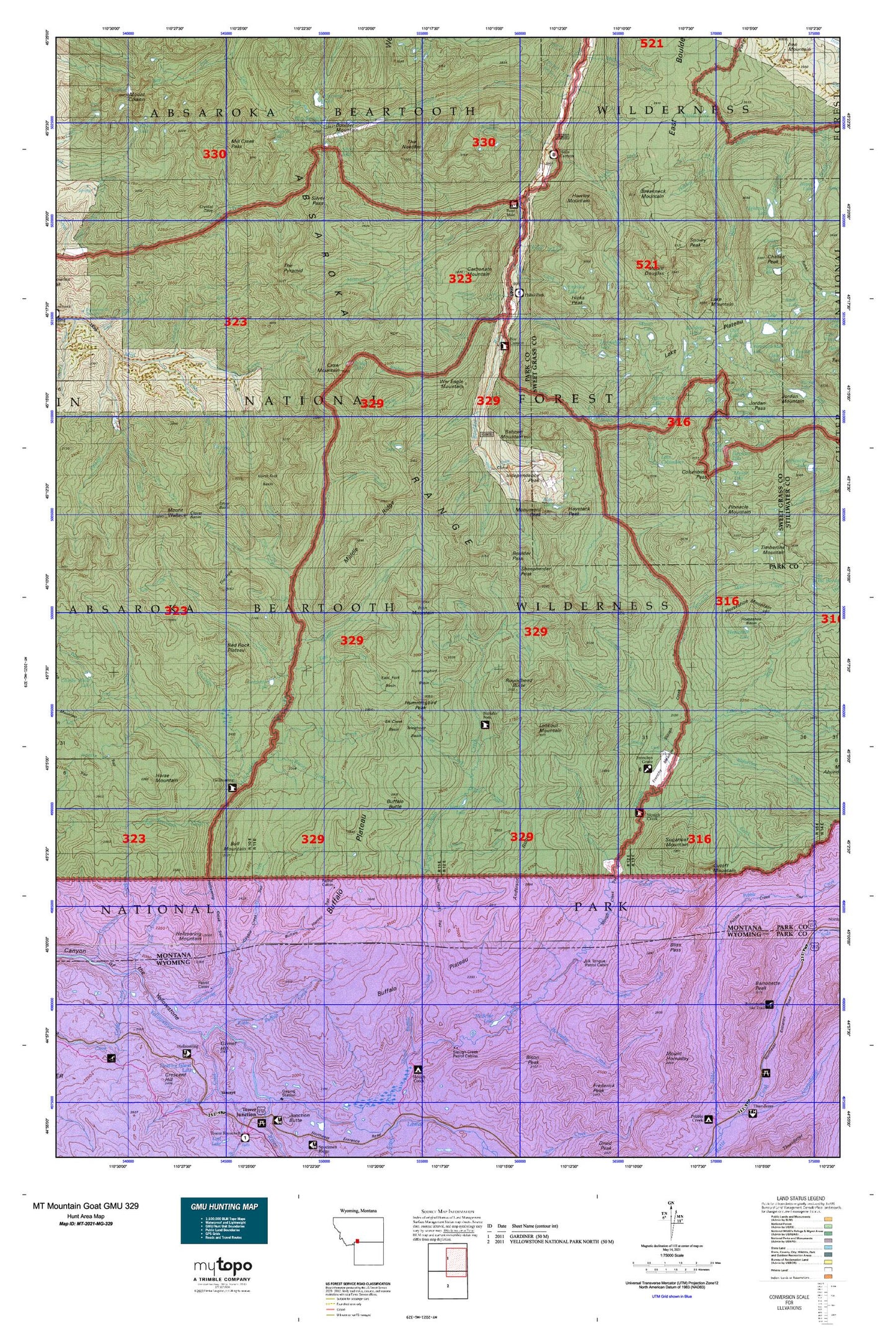
Hunting unit map of Montana Game Management Unit MG-329 with topographic lines and unit boundaries. This topo map features UTM / MGRS and Latitude/Longitude grids, plus public land ownership. It comes folded on waterproof paper. Be fully prepared for your hunt with a MyTopo GMU map!.
This map contains the following named places: 59020,Absaroka-Beartooth Wilderness,Agate Springs,Anderson Creek,Anderson Ridge,Armour Pond,Baboon Mountain,Barronette Peak,Basin Creek,Beaver Creek,Bliss Pass,Blue Lake,Boulder Mountain,Boulder Pass,Box Canyon Guard Station,Bramble Creek,Breakneck Mountain,Breakneck Plateau,Bridge Creek,Bridge Lake,Brundage Creek,Buffalo Butte,Buffalo Fork Ranger Station,Buffalo Plateau,Buffalo Plateau Patrol Cabin,Buffalo Plateau Trail,Bull Creek,Bull Moose Cabin,Bull Mountain,Burnt Gulch Lake,Camp Mimanagish,Camp-on-the-Boulder,Carbonate Mountain,Carpenter Lake,Cat Creek,Christikon,Cirque Lake,Clear Creek,Clover Basin,Clover Creek,Colley Creek,Colley Lake,Columbine Creek,Columbine Pass,Columbine Peak,Copper Creek,Cowles Post Office,Coyote Creek,Coyote Creek Trail,Crow Mountain,Crown Mine,Crystal Lake,Cutoff Creek,Cutoff Mountain,Delta Mine,Divide Creek,Divide Creek Lake,East Branch Hellroaring Creek,East Fork Basin,East Fork Boulder River,East Fork Buffalo Fork,East Fork Hellroaring Creek,East Fork Wallace Creek,East Fork West Boulder River,Elbow Lake,Elk Creek,Elk Creek Basin,Elk Lake,Elk Tongue Creek,Emerald Lake,End Lookout,Favonius Lake,Firewater Creek,Fish Lake,Fourmile Creek,Fourmile Guard Station,Frenchy Creek,Frenchy Meadow,Gallatin National Forest,Gardiner-Cooke City Division,Grassy Creek,Grizzly Creek,Hawley Creek,Hawley Mountain,Haystack Peak,Hellroaring Creek,Hellroaring Mountain,Hellroaring Ranger Station,Hells Canyon Campground,Hells Canyon Ranch,Hicks Park Campground,Hicks Peak,Hicks Post Office,Hidden Creek,Hidden Lake,Hidden Treasure Mine,Hornaday Creek,Horse Creek,Horse Mountain,Horseshoe Basin,Horseshoe Lake,Horseshoe Mountain Adit Mine,Horseshoe Mountain Shaft,Hummingbird Basin,Hummingbird Peak,Hyman Creek,Independence,Independence A Mine,Independence Mine,Independence Peak,Independence Post Office,Iron Mountain,Kaufman Lake,Knife Creek,Lake Abundance Creek,Lake Columbine,Lake Diaphanous,Lake Kathleen,Lake Mountain,Lake Plateau,Lambert Creek,Lazy Day,Lazy Day Post Office,Lazy Day Ranch,Lewis Creek,Little Buffalo Creek,Lookout Mountain,Lost Creek,Marie Creek,Martes Lake,Maxwell Post Office,McBride Lake,Meatrack Creek,Middle Fork Hellroaring Creek,Middle Ridge,Mill Creek Pass,Mirror Lake,Monument Peak,Mount Douglas,Mount Wallace,Mouse Lake,North Fork Basin,North Fork Bull Creek,North Fork Clover Creek,North Fork Hawley Creek,North Fork Hellroaring Creek,NW Section 22 Mine,Omega Mine,Owl Lake,Pentad Lake,Pinnacle Mountain,Pipit Lake,Poacher Trail,Poor Man Number 2 Mine,Poor Man/Emma Mine,Rainbow Creek,Rainbow Lakes,Raspberry Creek,Red Rock Plateau,Rock Creek,Roundhead Butte,Ruby Creek,SE Section 22 Mine,Second Fork West Fork Buffalo Fork,Sheep Creek,Sheepherder Peak,Silver Basin,Silver Creek,Silver Lake,Silver Pass,Silver Tip Ranch,Slough Creek Guard Station,Snowslide Creek,Snowy Peak,Solomon City,South Fork Bridge Creek,South Fork Bull Creek,South Fork Sheep Creek,Specimen Creek,Specimen Falls,Speculator Creek,Speculator Creek Mine,Sugarloaf Mountain,Sundown Lake,Sunken Rock Lake,Telephone Basin,The Hole,The Needles,The Pyramid,Trail Creek,Trout Lake,Tucker Creek,Tuscarora Creek,Upsidedown Creek,War Eagle Mountain,West Boulder Lake,West Fork Buffalo Creek,Wolverine Creek,Wounded Man Creek,Wounded Man Lake,Yager/Daisy Mine,Yellowstone River Trail