MyTopo
Montana Mountain Goat GMU 414 Map
Couldn't load pickup availability
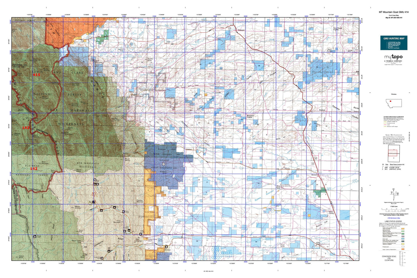
Hunting unit map of Montana Game Management Unit MG-414 with topographic lines and unit boundaries. This topo map features UTM / MGRS and Latitude/Longitude grids, plus public land ownership. It comes folded on waterproof paper. Be fully prepared for your hunt with a MyTopo GMU map!.
This map contains the following named places: 25N06W30DBD_01 Well,27N08W13CDD_01 Well,59419,59467,Antelope Butte,Ben English Coulee,Bennie Creek,Bennie Hill,Bills Coulee,Blackleaf,Blackleaf Canyon,Blackleaf Creek,Blackleaf Post Office,Blackleaf School,Blackleaf Wildlife Management Area,Blacktail Creek,Blindhorse Creek,Bloody Hill,Bowl Mountain,Bruce Creek,Bull Creek,Bum Shot Mountain,Burfening Ranch,Bynum Reservoir,Bynum Reservoir Dam,Bynum Reservoir Ditch,Bynum Reservoir Fishing Access Site,Canyon Creek,Cave Mountain,Cave Mountain Campground,Chicken Coulee,Choteau Division,Choteau Mountain,Circus Creek,Clark Brothers Ranch,Clark Fork Muddy Creek,Clary Coulee,Corrugate Ridge,Cow Creek,Cow Track Ranch,Crab Butte,Crary Ranch,Crawford Ranch,Crazy Creek,Crooked Mountain,Decameter Dam,Decarboxylation Dam,Decuman Dam,Deminish Dam,East Fork North Fork Teton River,Elko Recreation Site,Empty Jug Cabin,Farmers Coop Canal Company Dam,Farmers Reservoir,Field Creek,Fish Lake,Fish Lake Dam,Floating Rib Dam,Frenchy Gulf,Fright Creek,Gansman Coulee,Garners Gulch,Gordon Post Office,Happy Creek,Harmony School,Harvey Lake,Harvey Lake Dam,Haywood Creek,Hell Roaring Spring,Highview School,Hines Ranch,Hoy Coulee,Hoy Gulch,Hughes Ranch,Hungry Man Creek,Hurricane Mountain,Indian Burial Ground,Indian Head Rock,Jensen Coulee,Jensen Ranch,Jones Coulee,Jones Creek,Jones Creek National Recreation Trail,Kid Creek,Knowlton Ranch,Lake Creek,Lazy P Ranch,Lenstra Creek,Lewis and Clark National Forest - Rocky Mountain Division,Massey Creek,Middle Fork Birch Creek,Middle Fork Dupuyer Creek,Middle Fork North Fork Teton River,Middle Fork Trailhead,Miller Ditch,Mount Drouillard,Mount Frazier,Mount Lockhart,Mount Patrick Gass,Mount Richmond,Mount Sentinel,Mount Werner,Mount Wright,My Creek,Nanny Creek,Nesbit Creek,North Fork Birch Creek,North Fork Dupuyer Creek,North Fork Teton River,Old Man of the Hills,Olney Creek,Olson Ranch,Ostle Ranch,Pamburn Creek,Pelzman Ranch,Phillips Creek,Phone Creek,Pings Coulee,Pinky Creek,Pinto Creek,Pollock Ranch,Porcupine Creek,Post Creek,Potshot Creek,Ringy-Dingy Dam,Rinker Creek,Rival Creek,Rockport Colong Number 1 Dam,Rockport Colony,Rockport Colony Census Designated Place,Rockport Colony Number 2 Dam,Rockport Colony School,Round Lake,Scoffin Butte,Scoffin Creek,Scott Ranch Dam,Soap Creek,South Creek,South Fork Birch Creek,South Fork Dupuyer Creek,South Fork Teton River,Split Mountain,Spring Hill,Spring Hill Ranch,Steedling Creek,Sullivan Ranch,Swift Dam,Swift Dam Trailhead,Swift Reservoir,Tedson Reservoir,Tedson Reservoir Dam,Teton Pass,Teton Pass Winter Sports Area,Teton Peak,Tetonview School,Theodore Roosevelt Memorial Ranch,Toms Coulee,Tubby Creek,Twin Lake Dam,Twin Lakes,Twin Lakes Dam,Volcano Reef,Waldron Creek,Walling Reef,Wapiti Ridge,Washboard Reef,Washout Creek,West Fork Campground,West Fork Jones Creek National Recreation Trail,West Fork North Fork Teton River,West Fork Ranger Station,West Fork Teton Recreation Site,Wind Mountain,Woods Coulee,Wrangle Creek,Wright Creek,Wrong Creek Guard Station,Wrong Ridge