MyTopo
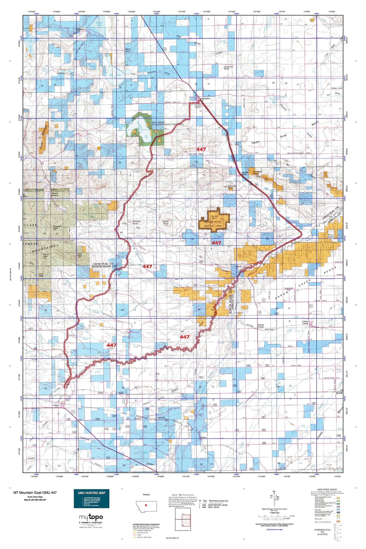
Montana Mountain Goat GMU 447 Map
Couldn't load pickup availability
Hunting unit map of Montana Game Management Unit MG-447 with topographic lines and unit boundaries. This topo map features UTM / MGRS and Latitude/Longitude grids, plus public land ownership. It comes folded on waterproof paper. Be fully prepared for your hunt with a MyTopo GMU map!.
This map contains the following named places: 17N10E01AB__01 Spring,17N10E01AB__02 Spring,17N10E01BA__01 Spring,17N10E01DD__01 Well,17N10E02BD__01 Spring,17N10E02CC__01 Well,17N10E03AC__01 Spring,17N10E03BA__01 Well,17N10E03CD__01 Spring,17N10E03DC__01 Spring,17N10E04DC__01 Well,17N10E04DD__01 Spring,17N10E05BC__01 Well,17N10E05CCD_01 Well,17N10E05CD__01 Well,17N10E05CD__02 Well,17N10E05CD__03 Well,17N10E05DCDB01 Well,17N10E05DD__01 Well,17N10E06DD__01 Well,17N10E08BA__01 Spring,17N10E08CC__01 Well,17N10E08CC__02 Spring,17N10E09AB__01 Spring,17N10E09DC__01 Well,17N10E09DC__02 Well,17N10E10DC__01 Well,17N10E12BA__01 Spring,17N10E12DC__01 Spring,17N10E13BA__01 Well,17N10E14AB__01 Well,17N10E14AB__02 Well,17N10E14AB__03 Well,17N10E15BB__01 Well,17N10E16BB__01 Well,17N10E16BB__02 Well,17N10E17AB__01 Well,17N10E17AB__02 Well,17N10E17ABAC01 Well,17N10E17BB__01 Well,17N11E03CB__01 Spring,17N11E04DD__01 Spring,17N11E05BD__01 Well,17N11E05DB__01 Well,17N11E05DB__02 Well,17N11E07CD__01 Spring,17N11E07DD__01 Well,17N11E08DA__01 Well,17N11E12AB__01 Spring,17N11E12DB__01 Well,17N11E18AA__01 Well,17N12E01DC__01 Well,17N12E01DC__02 Well,17N12E01DC__03 Well,17N12E03AA__01 Well,17N12E03AB__01 Well,17N12E06AD__01 Well,17N12E06AD__02 Well,17N12E06AD__03 Well,17N12E06AD__04 Well,17N12E06AD__05 Well,17N12E06DC__01 Well,17N12E10AD__01 Well,17N12E10AD__02 Well,17N12E10AD__03 Well,17N12E10AD__04 Well,17N12E11B___01 Well,17N12E11BC__01 Well,17N12E15BA__01 Well,17N12E15BA__02 Well,17N12E15BA__03 Well,17N12E17BB__01 Well,17N12E18AA__01 Spring,17N12E18AA__02 Well,17N13E06AA__01 Well,18N10E01BD__02 Spring,18N10E01BD__03 Spring,18N10E01DD__02 Spring,18N10E05BB__01 Spring,18N10E07DD__02 Spring,18N10E18AD__01 Spring,18N10E22CD__01 Spring,18N10E22DA__01 Spring,18N10E23DA__01 Spring,18N10E24CB__01 Spring,18N10E25BA__01 Spring,18N10E28AD__01 Spring,18N10E32CC__01 Well,18N10E32CCCA01 Well,18N10E34CC__01 Spring,18N10E35CD__01 Well,18N10E35CDCD01 Well,18N10E35DD__01 Spring,18N11E04AB__01 Spring,18N11E05CC__01 Spring,18N11E16DA__01 Spring,18N11E21AA__01 Spring,18N11E24DD__02 Spring,18N11E30AB__01 Spring,18N11E30CD__01 Spring,18N11E32DB__01 Spring,18N11E33BB__01 Spring,18N11E34BC__01 Spring,18N11E35CA__01 Spring,18N12E04AA__02 Spring,18N12E07CD__01 Spring,18N12E13AD__01 Spring,18N12E20BB__01 Spring,18N12E23CD__02 Spring,18N12E29AB__01 Spring,18N12E31DD__01 Well,18N12E35AB__03 Spring,18N13E05BAD_01 Spring,19N10E13BC__01 Spring,19N10E14DA__01 Spring,19N10E15DA__01 Spring,19N10E15DC__01 Spring,19N10E17AC__01 Spring,19N10E17BB__01 Spring,19N10E17BD__01 Spring,19N10E17DA__01 Spring,19N10E19AA__01 Spring,19N10E19AD__01 Spring,19N10E20AB__01 Spring,19N10E20DA__01 Spring,19N10E21AB__01 Spring,19N10E22DB__01 Spring,19N10E22DC__01 Spring,19N10E24BB__01 Spring,19N10E24BC__01 Spring,19N10E24BD__01 Spring,19N10E27CB__01 Spring,19N10E28AC__01 Spring,19N10E28CA__03 Spring,19N10E28CB__01 Spring,19N10E29BD__01 Spring,19N10E32CB__01 Spring,19N10E32CD__01 Spring,19N10E33BD__01 Spring,19N11E20DA__01 Spring,19N11E31BD__01 Spring,19N11E32DA__03 Spring,59424,59446,59447,Alder Creek,Antelope Butte,Arrow Creek,Arrow Creek Spring,Big Coulee,Big Flat Spring,Big Lake,Black Rock,Boyd Creek,Braun Creek,Buckskin Butte,Butte Creek,Central Montana Cooperative Elevator,Chalk Cliffs,Chimney Creek,Chouteau County Waterfowl Production Area,Complimentary Dam,Corral Creek,Cottonwood Creek,Davis Creek,Deuteronomy Dam,Dieanira Dam,Dipping Vat Creek,Dordrecht Dam,Doukhobors Dam,Draco Dam,Dramamine Dam,East Peak,Fall Creek,General Mills Incorporated Elevator,Geraldine,Geraldine Airport,Geraldine Cemetery,Geraldine Division,Gerard Creek,Geyser,Geyser Census Designated Place,Geyser Elevator,Hay Creek,Haystack Butte,In-moolsh Creek,Jensen Spring,Jiggs Flat,Kelley Creek,Kheta Dam,Kingsbury Lake,Leiberg Coulee,Lepley,Lepleys Creek,Libby Hills,Little Battle Creek,Little Phantom Dam,Lone Tree Creek,Lonetree,Lost Lake,Mansfield Creek,Martin Creek,McCarthy Creek,Merino,Merino Bench,Merrill Creek,Missouri Wolf Dam,Montague,Montague Cemetery,Mud Spring Coulee,Mud Springs,Ole Coulee,Owen Bros Airport,Palisade Butte,Panton Coulee,Panton Coulee Reservoir,Phantom Coulee Reservoir Dam,Pownal,Rose Creek,Round Butte,Shed Creek,Spring Creek,Square Butte,Square Butte Census Designated Place,Surprise Creek,Telephone Coulee,The Badlands,Thurston Dam,Timber Creek,Tolan Creek,Town of Geraldine,Warren Creek,West Fork Flat Creek,Willow Creek,Windy Coulee


