MyTopo
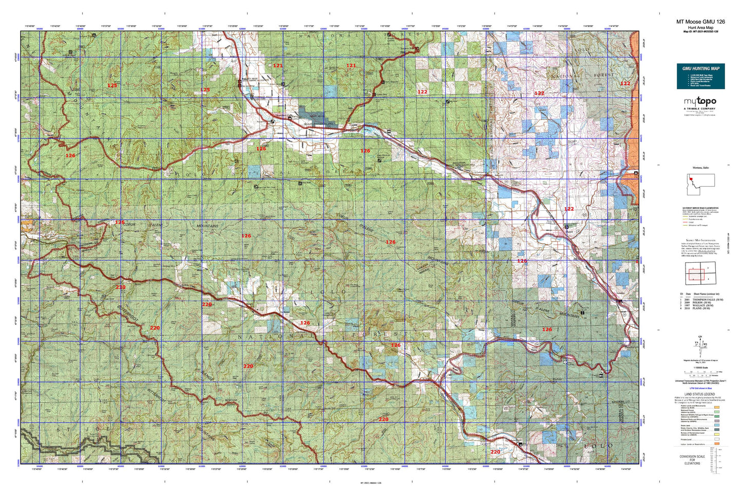
Montana Moose GMU 126 Map
Couldn't load pickup availability
Hunting unit map of Montana Game Management Unit MOOSE-126 with topographic lines and unit boundaries. This topo map features UTM / MGRS and Latitude/Longitude grids, plus public land ownership. It comes folded on waterproof paper. Be fully prepared for your hunt with a MyTopo GMU map!.
This map contains the following named places: Acorn Lake,Adair,Adams Peak,Andys Knob,Antimony Creek,Armada,Arvilla Lookout Station,Ashley Creek,Ashleys Settlement,Bald Hill,Bald Mountain,Beaver Lake,Beaver Peak,Bemish Creek,Bernier Point,Big Creek,Big Hole Peak,Big Sunday Creek,Birdland Bay RV Resort,Bitterroot Ferry,Blackburn Creek,Bluebird Point,Borax,Borax Creek,Boyd Mountain,Brimstone Creek,Brooks Mountain,Brownman,Bryson,Buffalo Bill Creek,Buford,Bullion,Burke Creek,Burke Summit,Burnt Flats Creek,Cabin City,Cabin City Campground,Camels Hump Lookout Station,Cameron Creek,Cameron Peak,Camp Creek,Campground Saint Regis,Cantonment Jordan,Canyon Creek,Cedar Creek,Cherry Creek,Cherry Peak,Chipmunk Creek,City of Thompson Falls,Clark Mountain,Clear Creek,Clear Lake,Clear Peak,Cold Creek,Cold Peak,Combest Peak,Cook Creek,Copper King Campground,Copper Lake,Coyle Creek,Craddock Peak,Crittenden Peak,Cromie Creek,Crow Creek,Cruzane Mountain,Crystal Lake,Daisy Creek,De Borgia,Dee Creek,Deer Creek,Demont Creek,Denna Mora Campground,Denna Mora Creek,Dominion Creek,Dominion Peak,Drexel,Driveway Peak,Drury Peak,Dry Creek,Dry Fork,Eagle Peak,East Fork Big Creek,East Fork Cherry Creek,East Fork Crow Creek,East Fork Dry Creek,East Fork Packer Creek,East Fork Swamp Creek,East Fork Timber Creek,East Fork Twelvemile Creek,East Portal,East Twin Creek,Eddy,Eddy Creek,Eddy Mountain,Elk Point,Emma Peak,Evans Lake,Falcon,Fisher Creek,Flat Rock Creek,Flat Rock Lookout Station,Flathead Post,Flatiron Ridge Recreation Site,Flattop Mountain,Foraker,Ford Hill,Frost,Goat Mountain,Gold Lake,Gold Peak,Gold Rush Campground,Grays Peak,Green Mountain Creek,Greenwood Hill,Halfway House Historical Site,Halfway House Historical SIte,Hartman,Haugan,Haugan Mountain,Hawk Mountain,Hazel Lake,Heart Lake,Hemlock Mountain,Henderson,Henderson Hill,Hill Seven,Holacaust Historical Marker,Hougan,Hub Lake,John Mullan Statue,Kelly Pinnacle,Kinneys Spur,Kitchen,Lenora Lake,Little Joe Lookout Station,Little Saint Joe,Long Liz Point,Lookout,Lookout Pass Ski Area,Malin Point,Mann,Mary Lake,McGee Peak,McKay Landing Fishing Access Site,Meadow Mountain,Miller Park,Milroy,Mirror Peak,Montana City,Moon Peak,Mount Bushnell,Mountain House Historic Site,Mullan Road Historical Marker,Newman Peak,Olson Peak,Outlaw Lake,Penrose Peak,Petes Point,Pinehurst,Point Eightyone,Point Henry,Polleys Spur,Pottsville,Quail Lake,Quarles Peak,Red Hill,Riverfront RV Park and Cabins,Rivers Peak,Rock Creek Vista,Roland,Roland Point,Rudie Lake,Runt Mountain,Russell,Sacajawea Peak,Safety Spur,Saint Regis,Saint Regis Beacon,Saint Regis Fishing Access Site,Saint Regis KOA Kampgrounds,Saint Regis Riding Stables Campground,Saleesh House,Saltese,Saltese Mountain,Saltese Rest Area,Savenac Nursery,Shefoot Mountain,Sildix,Silver Dollar Inn Campground,Silver Lake,Snider,Sohon,Spruce Creek,Square Lake,Steamboat Island,Storm Peak,Sunset Peak,Table Top Mountain,Taft,Taft Peak,Taft Summit,Tamarack Hill,Tammany,Tanglefoot Point,Tarbox Hill,The Pines,Thompson Falls,Thompson Falls Campground,Thompson Falls Dam Point of Interest,Thompson Falls Golf Club,Thompson Falls Historical Marker,Thompson Falls Reservoir,Thompson Falls State Park Campground,Thompson Falls State Recreation Area,Thompson River Spur,Tin Can Hill,Toole,Trestle Creek Golf Club,Tuffys Lake,Turkey Point,Turner Peak,Twentyfour Mile Creek,Twentythree Mile Creek,Twomile Pond,United States Forest Service Fire Station,Up Up Mountain,Ward Cabin,Ward Peak,Weeksville,Wence,West End Division,West Fork Middle Fork Big Creek,Wileys,Wishard Peak,Woodlin