MyTopo
Montana Moose GMU 211 Map
Couldn't load pickup availability
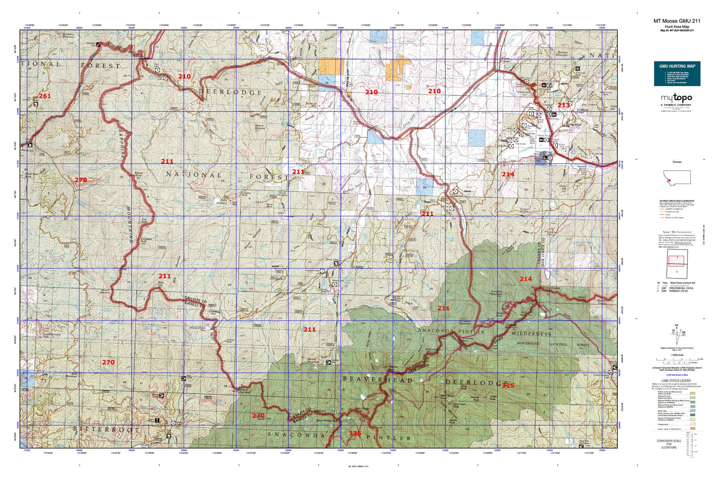
Hunting unit map of Montana Game Management Unit MOOSE-211 with topographic lines and unit boundaries. This topo map features UTM / MGRS and Latitude/Longitude grids, plus public land ownership. It comes folded on waterproof paper. Be fully prepared for your hunt with a MyTopo GMU map!.
This map contains the following named places: Abe Lincone Mine,Anaconda Pintler Wilderness,Angelico Creek,Banner Mine,Bare Hill,Barnett Meadows,Beaverhead Mountain,Bentz Mine,Big Spring Creek,Bitterroot Pass,Blodgett Gulch,Blue Grotto Spring,Blue Mountain,Bowles Creek,Bush Creek,Camp Spring,Carey Lateral,Carpp Creek,Carpp Lake,Carpp Mine,Carpp Ridge,Charity Lake,Comers Point Picnic Area,Congdon Mine,Congdon Peak,Copper Creek,Copper Creek Campground,Corral Gulch,Cougar Creek,Cow Camp Meadows,Coyote Meadows,Crystal Creek,Crystal Point,Cuba Creek,Cutaway Mountain,Cutaway Pass,Cutthroat Creek,Dearborn Gulch,Deer Meadows,Deerlodge National Forest,Dexter Basin,Dexter Creek,Dry Gulch,Eagle Canyon,East Fork Campground,East Fork Reservoir,East Fork Rock Creek,East Goat Peak,East Pintler Peak,Eccelston Boat Docks,Edith Lake,Elk Creek,Emerine Spring,Faith Lake,Falls Creek,Falls Fork Rock Creek,Fish Lake,Fish Lake Trailhead,Fish Peak,Flint Creek Canal,Flower Lake,Fox Creek,Fox Peak,Frogpond Basin,George Lake,Georgetown Lake Volunteer Fire Company Station 2,Glover Basin,Gods Little Acre Meadows,Green Canyon Creek,Green Canyon Lake,Haggin Dude Ranch,Happy Creek,Helm Creek,Hi Line Trail,Hicks Lake,Hog Trough Creek,Hole in the Wall,Hope Lake,Ivanhoe Lake,Jericho Bay Campground,Jerry Lake,Johnson Lake,Kaiser Lake,Kent Lake,Kent Mine,Kent Peak,Lake Abundance,Lion Lake,Little Fish Lake,Little Johnson Lake,Lone Pine Ridge,Long Peak,Lost Lakes,Lost Tooth Cabin,Lower Carpp Lake,Lutz Creek,Lutz Mine,Maloney Basin,Mariposa Post Office,Martin Lake,Maukey Gulch,McDonald Mine,McDougal Gulch,McGlaughlin Peak,Meadow Creek,Medicine Lake,Meyers Creek,Middle Fork Rock Creek,Miller Mine,Millers Mine,Milo Lake,Moly Group,Montana Prince Mine,Moose Creek,Moose Lake,Moose Lake Mine,Moose Meadow Creek,Moose Meadows,Moose Mountain,Mosquito Meadows,Mount Emerine,Mud Lake,NE NE Section 6 Mine,NE SE Section 14 Mine,Needle Peak,Nipple Peak,North Fork Rock Creek,O'Brien Mine,Old Dominion Mine,One Hundred Acre Meadow,Oreamnos Lake,Page Creek,Paint Creek,Phyllis Lake,Pintler Pass,Pintler Peak,Placer Creek,Point Lookout,Poison Creek,Pollywog Spring,Porter Ridge,Potato Lakes,Queener Basin,Railroad Creek,Rainbow Lake,Rainbow Mountain,Reynolds Creek,Rooster Comb,Ross Fork,Saddle Mountain,Sagebrush Flat,Sand Basin,Sand Basin Creek,Sandy Beach Campground,Sapphire Mountains,Sauer Creek,Sauer Lake,Schoolmarm Gulch,SE NE Section 6 Mine,SE Section 17 Mine,Senate Creek,Senate Mine,Senate Mountain,Shadow Lake,Showers Creek,Sign Creek,Sign Creek Trailhead,Sign Signal Trailhead,Signal Rock,South Fork Rock Creek,South Fork Sleeping Child Creek,Spillway Campground,Spring Creek,Spruce Creek,Spruce Lake,Stephens Reservoir,Susie Lake,SW SW Section 25 Mine,Swamp Creek,Table Mountain,Tamarack Creek,Tamarack Lake,Tower Peak,Trail Creek,Trout Lake,Two Meadows,Upper Carpp Lake,Upper Phyllis Lake,Warren Lake,Warren Pass,Warren Peak,Water Sign Meadows,Weasel Creek,West Fork Beaver Creek,West Fork Rock Creek,West Fork Work Center,West Goat Peak,Whetstone Lake,Whetstone Ridge,Wilma Post Office,Wyman Creek,Zekes Meadows