MyTopo
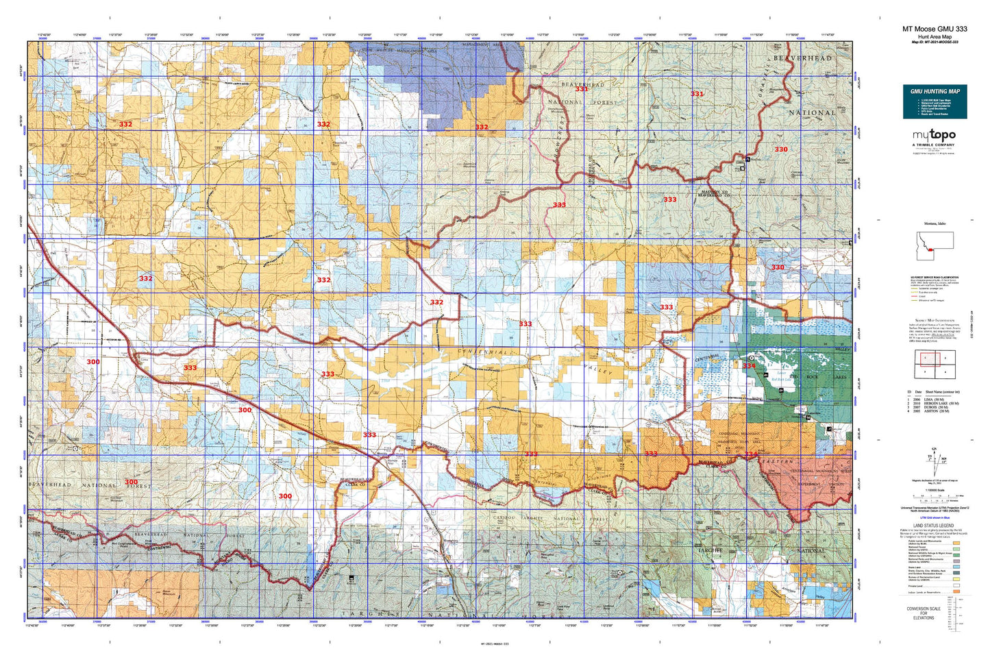
Montana Moose GMU 333 Map
Couldn't load pickup availability
Hunting unit map of Montana Game Management Unit MOOSE-333 with topographic lines and unit boundaries. This topo map features UTM / MGRS and Latitude/Longitude grids, plus public land ownership. It comes folded on waterproof paper. Be fully prepared for your hunt with a MyTopo GMU map!.
This map contains the following named places: 13S03W22CCBC01 Spring,14S03W23BBD_01 Spring,59739,83446,Alder Creek,Alex Draw,Anderson Creek,Antelope Flat,Antelope Peak,Antone Creek,Antone Guard Station,Antone Pass,Antone Peak,Ashbough Spring,Aspen Draw,Basin Creek,Bean Creek,Bear Canyon,Bear Creek,Bear Trap Creek,Beartrap Creek,Berry Creek,Big Beaver Creek,Big Spring Gulch,Big Table Mountain,Birch Creek,Bonita Fork,Brundage Creek,Burnt Canyon,Cabin Creek,Cactus Dam,Castle Creek,Castle Peak,Centennial Divide,Centennial Gulch,Centennial Valley,Chandelier Dam,Chicken Creek,Chris Cabin,Chute Canyon,Clark Fork,Clover Creek,Clover Divide,Coal Mine,Cooks Lake,Coon Creek,Cornell Camp,Cornell Ranch,Cornell Trail,Corral Creek,Crooked Run Creek,Crow Creek,Crows Nest Creek,Curry Creek,Deep Creek,Deep Creek Cow Camp,Diamond Butte,Disaster Creek,Ditch Creek,Divide Creek,Divide Creek Guard Station,Duffner Ranch,Dukes Fork,Dutch Hollow,Dutch Hollow Spring,East Camos Campground,East Creek Campground,East Fork Bear Gulch,East Fork Big Beaver Creek,East Fork Clover Creek,East Fork Corral Creek,East Fork Little Sheep Creek,East Fork Peet Creek,East Modoc Creek,East Steel Creek,Eureka Basin,Express Creek,First Wolverine Creek,Fish Creek Lake,Fish Dam,Flat Creek,Fox Creek,Frazier Creek,Fryingpan Creek,Garfield Mountain,Gosman,Grays Fork,Great Northern Railway Historical Marker,Grouse Creek,Hall Spring,Henry Gulch,Hirschi Flat,Horse Creek,Humphrey,Idaho Creek,Idaho Hollow,Indian Creek,Jones Creek,Jones Ranch,Jug Creek,Junction Creek,Kettle Creek,Knob Mountain,Knoll,Knox Spring,Lake Creek,Larkspur Creek,Lawrence Creek,Lima,Lima City Park,Lima Dam,Lima Peaks,Lima Reservoir,Lima-Centennial Valley Division,Little Basin Creek,Little Beaver Creek,Little Lake,Little Lake Creek,Little Sage Creek,Little Sheep Creek,Little Spring Gulch,Little Table Mountain,Lodgepole Trail,Lone Butte,Lone Pine Spring,Lone Willow Spring,Long Creek,Long Creek Spring Number One,Lousy Springs,Lower Deep Creek Spring,Lymans Creek,Meadow Creek,Merden Peak,Middle Creek,Middle Creek Cow Camp,Middle Modoc Creek,Modoc Creek,Mohican Creek,Monida,Monida Pass,Moonshine Gulch,Mount Carey,Mount Moriah Cemetery,Mud Lake,Mud Lake Dam,Mule Meadows,Mule Meadows Creek,Murphy Creek,Norris Canyon,Norris Spring,North Fork Corral Creek,Pands Dam,Pass Creek,Paul Dam,Paul Reservoir,Peet Creek,Perkins Creek,Peru Dam,Pete Creek,Pete Creek Divide,Peterson Basin,Peterson Mine,Pine Butte Station,Pinetop Hill,Piute Creek,Pocket Creek,Poison Creek,Pole Creek,Pole Creek Basin,Porcupine Pass,Price Creek,Price-Peet Divide,Red Butte,Red Canyon,Red Conglomerate Peaks,Red Rock,Robbins Creek,Rock Island Ranch,Rough Creek,Sage Creek,Salamander Creek,Sand Creek,Sandy Creek,Saw Creek,Sawmill Creek,Sawmill Spring,Sawtooth Mountain,Sawtooth Trail,Second Wolverine Creek,Seybold Spring,Sheep Creek,Shineberger Creek,Shovel Creek,Snowbank Ridge,Snowcrest Trail,Snowline,Snowline Ranch,South Fork Pole Creek,South Fork West Fork Blacktail Deer Creek,Sportsman Inn and RV Park,Spring Creek,Spring Gulch,Spruce Creek,Steamboat Rock,Steel Creek,Steel Creek Campground,Straight Creek,Stump Creek,Swamp Creek,Table Mountain Trail,Tenpin Gulch,The Basin,The Thumb,Tipton Creek,Town of Lima,Trail Creek,Truax Creek,Twin Springs,Two Meadows Creek,Vinegar Hill,Warm Springs Creek,Waters Flat,West Creek,West Fork Big Beaver Creek,West Fork Corral Creek,West Fork Little Sheep Creek,West Fork Price Creek,West Modoc Creek,West Steel Creek,Western Centennial Mountains,Whiskey Spring,Williams Camp,Willow Creek,Winslow Creek,Wolverine Creek