MyTopo
Montana Moose GMU 334 Map
Couldn't load pickup availability
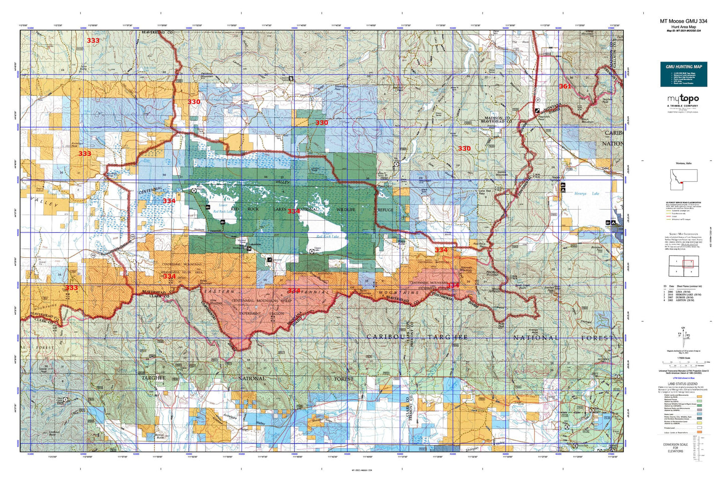
Hunting unit map of Montana Game Management Unit MOOSE-334 with topographic lines and unit boundaries. This topo map features UTM / MGRS and Latitude/Longitude grids, plus public land ownership. It comes folded on waterproof paper. Be fully prepared for your hunt with a MyTopo GMU map!.
This map contains the following named places: 13S01E28AACD01 Spring,13S01E29CAB_01 Spring,13S01E31DCAB01 Spring,13S01E33AAC_01 Spring,13S01E36DDD_01 Spring,13S01W04DCC_01 Spring,13S01W10BBA_01 Spring,13S01W12DAAC01 Spring,13S01W28BCBB01 Well,13S01W28DDD_01 Well,13S01W30CBA_01 Well,13S02W01BAA_01 Spring,13S02W05CAAA01 Spring,13S02W18ADC_01 Spring,13S02W26DDDB01 Well,13S03W22CCBC01 Spring,13S03W22DAAB01 Spring,13S03W23ABD_01 Spring,13S03W34BBCC01 Well,14S01E08DACC01 Spring,14S01E13BDA_01 Spring,14S01E17BDB_01 Well,14S01E20CAB_01 Spring,14S01E22ACBB01 Well,14S01E22DBAA01 Well,14S01E23BCC_01 Spring,14S01E24CDAA01 Well,14S01E29DBAB01 Spring,14S01W21CDD_01 Spring,14S01W22DDD_01 Spring,14S02E06CCCB01 Spring,14S02E07CBAD01 Spring,14S02W22AACD01 Well,14S02W23BABA01 Well,14S02W23BCA_01 Well,14S02W23BDAA01 Well,14S02W23BDDA01 Well,14S02W23CAA_01 Well,14S03W13DBCB01 Well,14S03W21DDCC01 Well,14S03W22CABD01 Well,14S03W23BBD_01 Spring,Alaska Basin,Aldous Lake,Allan Canyon,Antelope Basin,Antelope Creek,Antelope Peak,Antelope Pond,Anthill Creek,Anthill Spring,Arange Creek,Arrowhead Mountain,Baldy Mountain,Battle Creek,Bean Creek,Bear Creek,Bear Gulch,Bear Hole Trail,Bear Trap Creek,Big Table Mountain,Blair Lake,Blind Creek,Blind Creek Trail,Brays Butte,Brimstone Creek,Brundage Creek,Bunkhouse Creek,Burnt Canyon,Carrot Canyon,Castle Creek,Castle Peak,Cayuse Spring,Centennial Mountains,Coal Mine,Cole Creek,Conklin Lake,Cook Sheep Ranch,Coon Creek,Corral Creek,Cottonwood Creek,Culver Springs,Culver Springs Dam,Curry Creek,Deer Mountain,Disaster Creek,Dry Canyon,Dry Creek,Dry Creek Trail,Duff Creek,East Camos Campground,East Dry Creek,East Fork Bear Gulch,East Fork Dry Creek,East Fork Sheridan Creek,East Sheridan Creek Trail,East Steel Creek,Eastern Centennial Mountains,Edwards Ranch,Elk Creek,Elk Lake,Elk Lake Recreation Site,Elk Mountain,Elk Springs,Fish Creek,Frazier Creek,Frog Spring,Fruin Spring,Fryingpan Creek,Goble Ranch,Goose Lake,Hackett Creek,Hancock Lake,Hanson Ranch,Headquarters Trail,Hell Roaring Canyon,Hell Roaring Creek,Hidden Lake,Hidden Lake Bench,Hidden Lake Camp Ground,Hirschi Flat,Holt Ranch,Hoodoo Pass,Horn Mountains,Horse Creek,Horsemint Spring,Howard Creek,Howard Creek Trail,Humphry Creek,Icehouse Creek Dam,Jerry Creek,Jones Creek,Kay Creek,Keg Spring,Keg Spring Creek,Kick Creek,Lake Creek,Lake Marie,Lakeview,Lakeview Airport,Lakeview Census Designated Place,Lakeview Mountain Ski Area,Larkspur Creek,Lillian Lake,Limestone Creek,Little Creek,Lone Tree Creek,Lone Tree Pass,Lousy Springs,Lower Red Rock Lake,Lymans Creek,MacDonald Pond,Magdalen,Matsingale Creek,Metzel Creek,Metzel Creek Airport,Middle Fork Sheridan Creek,Middle Fork Trail,Mount Jefferson,Mud Creek,Mule Meadows,Mule Meadows Creek,Murphy Creek,Myers Creek,Myers Creek Trail,Narrows Creek,Nemesis Mountain,North Fork Duck Creek,Nye Creek,Odell Creek,Orr Ranch,Otter Lake,Pands Dam,Pasture Creek,Poison Creek,Pole Creek,Reas Peak,Red Rock Creek,Red Rock Lakes National Wildlife Refuge,Red Rock Lakes Wilderness,Red Rock Mountain,Red Rock Pass,Rock Creek Basin,Rock Spring,Saddle Mountain,Salamander Creek,Saw Creek,Scalp Creek,Schneider Creek,Selby Resort,Seven L Ranch,Shambow Creek,Shambow Pond,Sheep Mountain,Sheridan Creek Trail,Sheridan Dam,Sheridan Reservoir,Slide Mountain,Snoo-weh Pass,Snowshoe Creek,Snowshoe Pass,South Fork Duck Creek,Sparrow Slough,Spring Creek,Spruce Creek,Staudenmeyer Ranch,Steel Creek,Steel Creek Campground,Swan Lake,Table Mountain Trail,Taylor Creek Trail,Taylor Mountain,Taylor Mountain Mine,Tepee Creek,The Narrows,Tin Cup Creek,Tin Cup Trail,Tipton Creek,Tom Creek,Trail Creek,Twin Creek,Two Drink Springs,United States Sheep Experiment Station,Upper Lake Campground,Upper Red Rock Lake,Walking Fish Lake,Waters Flat,West Dry Creek,West Fork Sheridan Creek,West Steel Creek,Western Centennial Mountains,Widgeon Pond,Widgeon Pond Dam,Willow Creek Trail,Winslow Creek