MyTopo
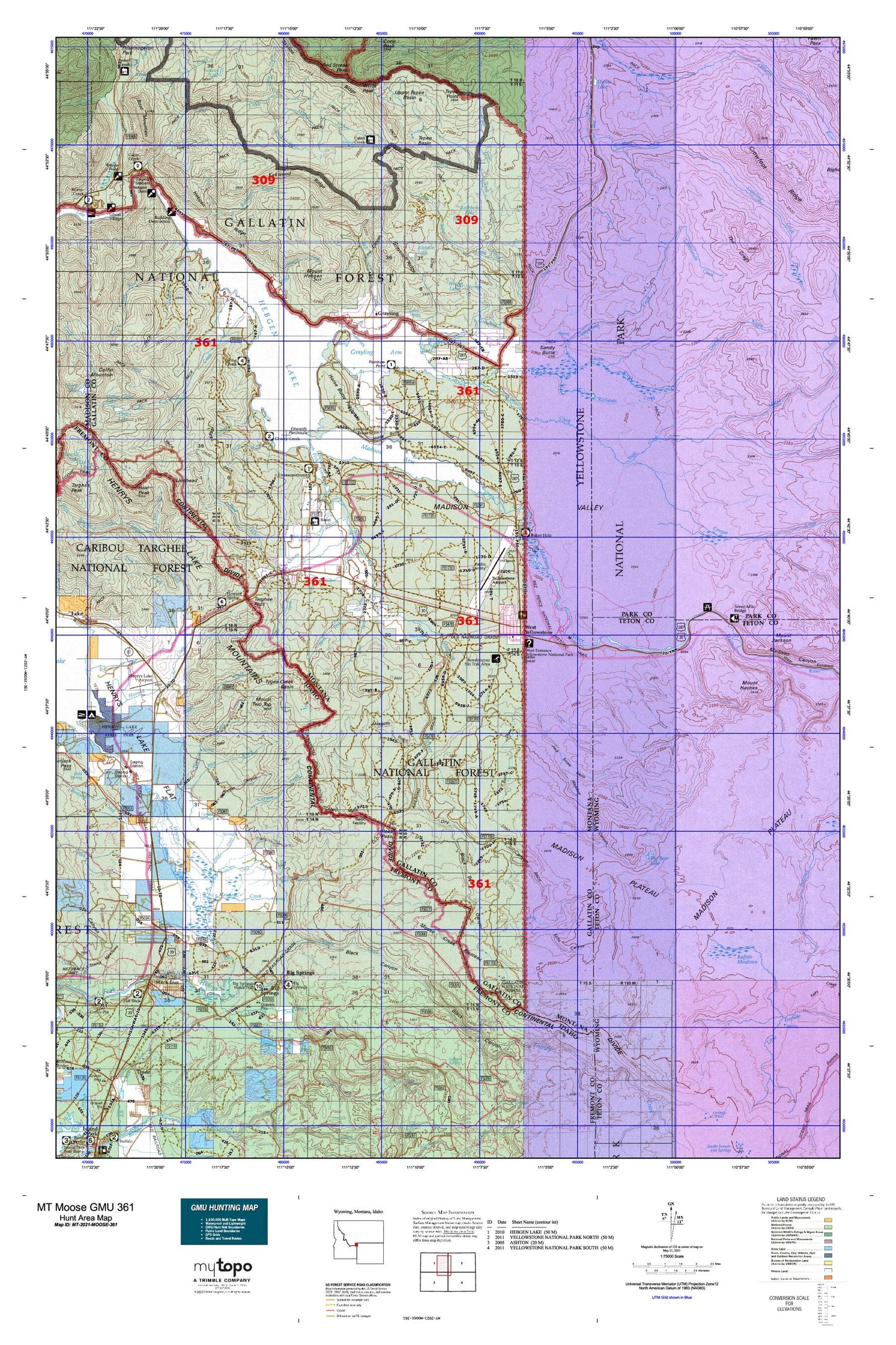
Montana Moose GMU 361 Map
Couldn't load pickup availability
Hunting unit map of Montana Game Management Unit MOOSE-361 with topographic lines and unit boundaries. This topo map features UTM / MGRS and Latitude/Longitude grids, plus public land ownership. It comes folded on waterproof paper. Be fully prepared for your hunt with a MyTopo GMU map!.
This map contains the following named places: 13S04E01BADD01 Well,13S04E02AABB01 Well,13S04E02BBBA01 Well,13S04E09DDDD01 Spring,13S04E10DDCA01 Well,13S04E14CDAD01 Spring,13S04E21ABDD01 Well,13S04E21DBBC01 Well,13S04E22ADCD01 Well,13S04E23CDCA01 Well,13S04E23DDDD02 Well,13S04E26AAAB01 Well,13S04E26BADB01 Well,13S04E26BB__01 Well,13S04E27AACA01 Spring,13S05E21DAAB01 Well,13S05E29DA__01 Well,13S05E31AC__01 Spring,13S05E31ACDA01 Spring,13S05E32CBDC01 Spring,13S05E34AABC01 Well,13S05E34ABBB01 Well,13S05E34ACCA01 Well,13S05E34ADBC02 Well,13S05E34BAAC01 Well,13S05E34BACD01 Well,13S05E34BBAB01 Well,13S05E34BBCC01 Well,13S05E34BBDC02 Well,13S05E34BC__01 Well,13S05E34BCCD01 Well,13S05E34CABB01 Well,13S05E34CADC01 Well,59758,83433,Ambassador RV Park,Axolotl Lake,Bakers Hole Campground,Bar N Ranch,Basin Cabin Spring,Basin Ranger Station,Beaver Ponds,Big Bear Lake,Big Springs,Big Springs Lookout,Black Bear Canyon,Black Canyon,Black Sand Spring,Boat Mountain,Bootjack Creek,Brandin Iron Motel and RV Park,Buffalo Meadows,Building Destruction Point of Interest,Buttermilk Creek,Cabin Creek,Cabin Creek Campground,Cabin Creek Divide Trail,Cabin Creek Ranger Station,Cabin Creek Wildlife Management Area,Campanula Creek,Campfire Lodge,Canyon Creek,Cherry Creek,Cherry Creek Campground,Clark Springs Group,Coal Canyon,Coffin Creek,Corette,Corey Spring,Cougar Creek,Cougar Creek Patrol Cabin,Cream Creek,Crooked Creek,Cub Creek,Dave Johnson Creek,Denny Creek,Divide Lake,Dry Canyon,Dry Creek,Dry Fork,Duck Creek,Dwelles Stage Stop,East Fork Cream Creek,East Fork Denny Creek,East Fork Targhee Creek,East Fork Tepee Creek,Echo Canyon,Edwards Peninsula,Edwards Point,Enget Creek,Fir Ridge Cemetery,Flat Rock,Flat Rock Guard Station,Forest Creek,Frog Pond,Garner Canyon,Garner Springs,Gneiss Creek,Gneiss Creek Trail,Graycroft Ridge,Grayling,Grayling Arm,Grayling Creek,Gully Creek,Hebgen Dam,Hebgen Lake,Hebgen Lake Estates Census Designated Place,Hebgen Reservoir,Hebgen Ridge,Henry's Lake Airport,Henrys Lake Flat,Henrys Lake Mountains,Henrys Lake Outlet,Hideaway RV Campground,Hilgard Lodge,Horse Butte,Horse Butte Acres Trailer Court,Horse Butte Peninsula,Howard Spring,Howard Spring Wayside,Howard Springs,Interagency Aerial Fire Control Center,Island Park Golf Course,Jack Straw Basin,Jesse Creek,Johnson Lake,Johnson Mine,Jones Creek,Kirkwood Creek,Kirkwood Ridge,Kirkwood Trail,La Siesta RV Park,Lake Hebgen Lodge,Lakeshore Summer Home Area,Lakeview,Lionhead,Lionhead Ski Area,Lionshead RV Park and Campground,Little Tepee Creek,Little Tepee Creek Trail,Lonesome Hurst Summer Home Area,Lonesomehurst Campground,Lonesomehurst Recreation Site,Lucky Dog Creek,Madison Arm,Madison Arm Resort,Madison Canyon,Madison Plateau,Madison Range Overlook,Madison River Lookout,Madison Valley,Maple Creek,Meadow Canyon,Meadow Creek,Middle Fork Cabin Creek,Moonlight Creek,Moonlight RV Park,Moose Creek,Moose Creek Plateau,Mosquito Gulch,Mount Haynes,Mount Hebgen,Mount Two Top,Mountain Spring Ranch,Mountain Springs,Nineteen Hundred Fifty-Nine Earthquake Historical Marker,North Fork Kirkwood Creek,Observation Point,Parade Rest Ranch,Pine Creek,Pulp Camp,Railroad Summer Home Area,Rainbow Point,Rainbow Point Campground,Rathbone Lake,Real Close Dam,Reas Pass,Reas Pass Creek,Red Canyon Creek,Richards Creek,Riverside,Rocky Draw,Romsett Summer Home Area,Rumbaugh Campground,Rumbaugh Creek,Rumbaugh Ridge,Ruof Ditch,Rustic RV Campground,Sandy Butte,Sawtell Creek,Slushers Point,South Fork Arm,South Fork Cabin Creek,South Fork Camp,South Fork Madison River,South Riverside Cabin,Spring Creek Campground,Stephens Creek,Sunset Lodge,Targhee Cemetery,Targhee Pass,Targhee Pass Historical Marker,Tepee Basin,Tepee Creek,Tepee Point,The Crags,The Narrows,Thirsty Creek,Timber,Town of West Yellowstone,Trapper Creek,Twin Creek,Tygee Creek,Tygee Creek Basin,Upper Tepee Basin,Wagon Wheel Campground,Wally McClure Creek,Watkins Creek,Watkins Creek Ranch,West Entrance,West Fork Cream Creek,West Fork Denny Creek,West Fork Trapper Creek,West Fork Watkins Creek,West Yellowstone,West Yellowstone District Ranger Office,West Yellowstone Division,West Yellowstone Town Park,White Peak,Whitmans Cabin,Whits Lakes,Yellowstone,Yellowstone Airport,Yellowstone National Park Division,Yellowstone Park KOA Campground