
MyTopo
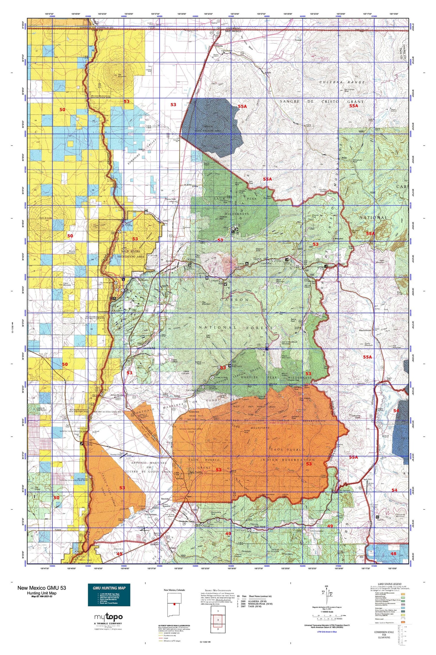
New Mexico GMU 53 Map
Couldn't load pickup availability
Hunting unit map of New Mexico Game Management Unit 53 with topographic lines and unit boundaries. This topo map features UTM / MGRS and Latitude/Longitude grids, plus public land ownership. It comes folded on waterproof paper. Be fully prepared for your hunt with a MyTopo GMU map!.
This map contains the following named places: Agua Fria,Amalia,Anchor,Andreou,Angel Fire,Antoine Leroux,Antonio Martinez or Godoi Grant,Apache Peak,Arroyo Hondo,Arroyo Hondo Division,Arroyo Hondo Grant,Arroyo Seco,Baldy Blue Lake,Baldy Cabin,Baldy Mountain,Bear Lake,Beaver Lake,Big Arsenic Springs Campground,Big Costilla Peak,Black Mountain,Blue Lake,Blue Lake Cabin,Brushy Mountain,Buena Vista,Bull-of-the-Woods Mountain,Bull-of-the-Woods Pasture,Cabresto Lake,Cabresto Lake Campground,Cabresto Park,Cabresto Peak,Canoncito,Capulin Peak,Carson Forest Service Station,Casita de Piedra Peak,Cebolia Mesa Campground,Cebolla Mesa,Cerrito Colorado,Cerro,Cerro Chiflo,Cerro Montoso,Cerro Negro,Cerro Weather Station,Cerros de Taos Ranch,Chiflo Campground,Chiflo Game Water Unit,Clayton Camp,Columbine Campground,Columbine Hondo Wilderness Study Area,Columbine-Hondo Wilderness,Comanche Point,Costilla,Costilla Lodge,Costilla Reservoir,Cow Lake,Cruz Alta Plaza,Cuchillo De Medio Campground,Cuchillo del Medio,D A V Vietnam Veterans National Memorial Historical Marker,D H Lawrence Ranch University of New Mexico Historical Marker,Del Monte Ranch,Ditch Cabin,Diversion Channel,Eagle Nest,Eagle Nest Lake,Eagle Nest Weather Station,Eagle Rock Campground,Eagle Rock Lake,El Aujae Campground,El Prado,El Renz-O-Ranch,El Rito,Elephant Rock Campground,Elizabethtown,Elizabethtown Historical Marker,Elizabethtown Weather Station,Enchanted Forest Cross Country Ski Area,Fawn Lakes,Fawn Lakes Campground,Flag Mountain,Foster Park,Fraser Mountain,Gallina Peak,Goathill Campground,Gold Hill,Goose Lake,Gorman,Green Meadows,Greenie Peak,Guadalupe Mountain,Guajalote Park,Harwood Foundation of the University of New Mexico Historic Site,Heart Lake,Heck,Hematite,Hondo Cabin,Hondo Forest Service Facility,Horseshoe Lake,Idlewild,Italian Park,Italianos Campground,June Bug Campground,Kiowa Village,Kit Carson Memorial State Park,Kit Carson State Park Cemetery Historical Marker,La Belle,La Belle Lodge,La Cueva Camp,La Junta Campground,La Loma Plaza Historic District,Lake Fork Peak,Lake Number Two,Lakeview Pines,Lama,Larkspur Peak,Latir Lakes,Latir Mesa,Latir Peak,Latir Peak Wilderness,Latir Rock Cairn,Lawrence Ranch,Lew Wallace Peak,Little Arsenic Springs Campground,Lobo,Lobo Hall,Lobo Peak,Lost Lake,Lower Hondo Campground,Lower Ranchito,Lucero Peak,Mallette Campground,McGreggor Antelope Guzzler,Memphis,Middle Fork Lake,Midnight,Moly,Monte Verde Unit Two,Moreno,Moreno Ranch,Moreno Valley,Mount Walter,Mutz,Mutz Ranch,Myers,New Buffalo Area,Old Mike Peak,Ortiz Peak,Palo Encebado Peak,Palo Flechado Pass Historical Marker,Perra Peak,Pinabete Peak,Pioneer Lake,Pope Lake,Pueblo de Taos Indian Reservation,Pueblo of Taos Historical Marker,Pueblo Peak,Questa,Questa Division,Questa Ranger District,Questa Ranger Station,Ranchito,Ranchos Peak,Red Dome,Red River,Red River Ski Area,Red River State Fish Hatchery,Red River Weather Station,Relica Peak,Rio Costilla Ski Area,Rio Grande Gorge Historical Marker,Rio Grande Rift Historical Marker,Rio Grande Wild and Scenic River Visitor Center,Rio Grande Wild River,Saint Vrains Mill Site,San Cristobal,San Pedro Mesa,Sangre de Cristo Camp,Sangre de Cristo Grant,Sawmill Mountain,Scully Mountain,Seven Lakes,Sheep Crossing Campground,Simpson Peak,Ski Rio,South Fork Peak,South Latir Lake,Star Lake,Sunshine,Sunshine Valley,Taos,Taos Administration Site,Taos Canyon Historical Marker,Taos Cone,Taos County,Taos Golf Course,Taos Historical Marker,Taos Peak,Taos Plaza End of the Camino Real,Taos Pueblo,Taos Pueblo Division,Taos Pueblo Grant,Taos Ranger Station,Taos Ski Valley,Taos Weather Station,Tenorio Tract Taos Pueblo,Tetilla Peak,Top O the World Farms,Top of the World Farms,Town of Red River,Tract A Taos Pueblo,Tract B Taos Pueblo,Tract C Taos Pueblo,Trujillo,Tunnel Hill,Turley Mill and Distillery Site,Twining,Twining Campground,Urraca Ranch,Ute Mountain,Val Verde Ski Area,Valdez,Vallecito Mountain,Van Diest Peak,Venado Peak,Ventero,Village of Eagle Nest,Village of Questa,Village of Taos Ski Valley,Virsylvia Peak,Vuicich,Water Bird Lake,Waterbird Lake,Wheeler Peak,Wheeler Peak Historical Marker,Wheeler Peak Wilderness,Williams Lake


