MyTopo
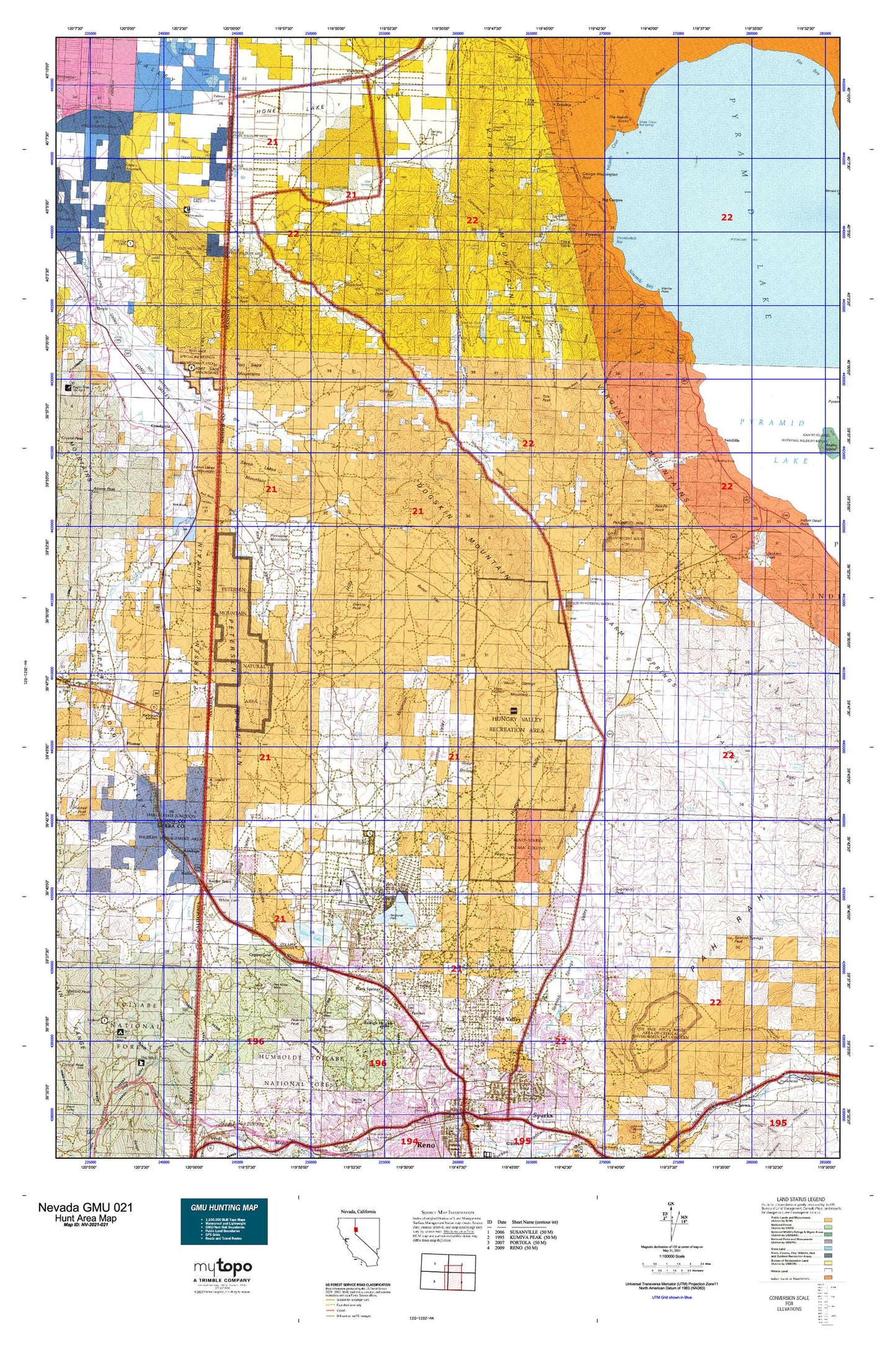
Nevada GMU 021 Map
Couldn't load pickup availability
Hunting unit map of Nevada Game Management Unit 021 with topographic lines and unit boundaries. This topo map features UTM / MGRS and Latitude/Longitude grids, plus public land ownership. It comes folded on waterproof paper. Be fully prepared for your hunt with a MyTopo GMU map!.
This map contains the following named places: 89433,89436,89441,89506,89508,89510,96105,Aldabe 291 Dam,Anderson,Anderson Canyon,Anderson Ranch,Antelope,Antelope Mine,Antelope Run,Antelope Valley,Auburn Mine,Axe Handle Canyon,Big Canyon,Big Canyon Ranch,Black Canyon,Black Panther Mine,Black Springs,BLM Fire Guard Station,Blondell Ranch,Border Town,Bristol,Buckeye Mine,Buckhorn Mine,Calneva,Calneva Lake,Cambell Mine,Cedar,Chats,Choates Mine,Cinch Mine,Cold Spring Park,Cold Springs,Constantia,Copperfield,Cottonwood Creek,Coyote Ridge,Crown Prince Mine,Crystal Peak Campground,Crystal Peak Guard Station,Curnow Canyon,Curnow Range,Delongchamps Mine,Dewey,Dickinson Ranch,Dogskin Mountain,Donatelli Mine,Doyle State Wildlife Area,Dry Lake,Dry Lakes,Dry Valley Creek,East Cottonwood Canyon,Emma Mine,Enchanted Beach,Ferretto Ranch,Fish Springs Creek,Fish Springs Ranch,Flanigan,Fort Sage Mountains,Francis,Francis Station,Fravel Mine,Freds Mountain,French Mountains,Gamble Mine,George Washington Rock,Golden Fleece Mine,Golden Valley,Grand View Terrace,Granite Hill Mine,Granite Hills,Granite Peak,Gregory Mine,Griffith Canyon,Guzzier,Hallelujah Junction,Hallelujah Junction Pit,Hardscrabble Canon,Hardscrabble Creek,Harolds Trap Shooting Club,Heinz,Hells Trap Shoot,Hornet Canyon,Hungry Mountain,Hungry Range,Hungry Ridge,Hungry Valley,Hunting Camp Number Four,Infant Mine,Jackass Peak,Jigger Bobb Canyon,Jones Creek,Jones Kincaid Mine,Junction House,Junction House Range,Juniper Basin,Juniper Ridge,Kimberly Hill,Left Hand Canyon,Lemmon Valley,Lemmon Valley Ranch,Lemmon Valley Shopping Center,Lemmon Valley Speedway,Little Valley,Lombardo Point,Long Valley Mill,Lowary Mine,Martin,Mayors Park,McClellans Creek,Meadow Valley,Middle Red Rock Valley,Milk Ranch Dam,Milk Ranch Reservoir,Monarch Mine,Mullen Creek,NAA Weather Station,Nashville,Needle Rock,Nevada Dominion Mine,Newcome Lake,Ninemile Bay,North Fork Dry Valley Creek,North Hill Shopping Center,North Valleys Division,Norton Mill,Old Cedar,Old Fish Farm,Omira,Orr Ditch,Pacific Pyramid Mine,Painted Hills,Paiute Canyon,Paiute Creek,Panther,Panther Valley,Paymaster Mine,Peavine,Peavine Mining District,Peavine Mountain,Peavine Peak,Pelican Point,Perry Canyon,Petersen Mountain,Picket Corral,Pine Ridge,Piute Canon,Poeville,Poison Canyon,Porcupine Mountain,Purdy,Purdy Creek,Pyramid,Pyramid Lake,Pyramid Mines,Pyramid Mining District,Quail Canyon Ranch,Raleigh Heights,Ransome,Rattlesnake Canyon,Red Canyon,Red Light Canyon,Red Metal Mine,Red Rock,Red Rock Canyon,Red Rock Valley,Reno-Sparks Indian Colony,Reno-Stead,Rhodes Creek,Right Hand Canyon,Rock Springs Canyon,Romolo,Ruth Mine,Sand Hills,Seven Lakes Mountain,Sharps Canyon,Sierra Sage Golf Course,Silver Knolls Park,Silver Lake,Sleepy Joe Mine,South Fork Dry Valley Creek,South Mountain,Spanish Flat Dam,Spanish Flat Reservoir,Spanish Springs,Spanish Springs Canyon,Spanish Springs Peak,Spanish Springs Ranch,State Line Peak,Stateline Peak Mining District,Stead Ranch,Sugar Loaf,Sugarloaf,Sugarloaf Peak,Sun Valley,Sun Valley Division,Sun Valley Park,Sutcliffe,Swan Lake,Telephone Pole Canyon,The Needle Rocks,Thunderbolt Bay,Thunderbolt Canyon,Tick Canyon,Trail Ranch,Tule Peak,Tule Ridge,Twenty Mile House,Twentyone Mile Hill,Upper Dry Valley,Upper Pyramid,Venetion Mine,Vinegar Peak,Virginia Mountains,Walker Mine,Warm Springs Mountain,Warm Springs Valley,Warm Springs-Truckee Canyon Division,Warrior Point,Water Hole Canyon,White Lake,Wildcat Hill,Winnemucca Ranch,Winnemucca Ranch Dam,Winnemucca Ranch Reservoir,Winnemucca Valley,Wizards Beach,Wizards Cove,Wood Canyon,Yellow Rock,Zenobia